Difference between revisions of "2012-05-25 54 -3"
imported>Matingslinkys (→Plans) |
imported>FippeBot m (Location) |
||
| (8 intermediate revisions by 2 users not shown) | |||
| Line 1: | Line 1: | ||
| − | |||
<!-- If you did not specify these parameters in the template, please substitute appropriate values for IMAGE, LAT, LON, and DATE (YYYY-MM-DD format) | <!-- If you did not specify these parameters in the template, please substitute appropriate values for IMAGE, LAT, LON, and DATE (YYYY-MM-DD format) | ||
| Line 15: | Line 14: | ||
}} | }} | ||
| − | + | ||
__NOTOC__ | __NOTOC__ | ||
== Location == | == Location == | ||
| Line 23: | Line 22: | ||
* [[User:RunawayBomber|RunawayBomber]] | * [[User:RunawayBomber|RunawayBomber]] | ||
| − | |||
* [[User:Matingslinkys|Matingslinkys]] | * [[User:Matingslinkys|Matingslinkys]] | ||
| Line 30: | Line 28: | ||
== Expedition == | == Expedition == | ||
| − | + | This was an interesting hash, as we were not sure if it was going to be remarkably easy, or absolutely impossible. [[George]] was right on the edge of Burgh Marsh, and it was not clear at all from the maps whether he was on dry land, or in the Solway Firth. If it was the former, we were home and dry, if the latter, not so much... | |
| + | |||
| + | Having met up, and enjoyed a short but pleasant drive to the marsh, we parked up, and bravely set forth through the marshlands. I say bravely. The marshes were not very marshy. Moist perhaps, but not marshy. I have it on good authority that they are usually marshy, but the week or so of hot weather had made it a pleasant potter interspersed with short hops over dryish creeks. (I also have it on good authority that the marsh can occasionally bring dysentery, leading to the death of Kings, and major developments in Anglo-Scottish relations but that, perhaps, is a story for another day...) | ||
| + | |||
| + | The bird-life was abundant, and whenever we accidentally ventured near a hidden nest we were loudly scolded by the locals! Driving onwards, despite this torrent of avian abuse, we approached George. The gentle curve of the landscape made it very hard to tell exactly where the marsh ended, and where the water began, so as the countdown got closer and closer to single figures it was not clear at all if the day would be won... | ||
| + | |||
| + | It all seemed lost when a clear edge to the marsh was spotted, with fast | ||
| + | flowing brown water beyond, and we were still 20 feet from George. This was going to | ||
| + | be a failure after all, and we had got so close! | ||
| − | + | But wait! What was this, a small cliff, with a beach beyond it, but only a very | |
| − | + | narrow beach; surely this would merely be mocking us, getting us closer, but not | |
| + | close enough, giving us hope, but then snatching it away! Oh cruel fate! | ||
| + | |||
| + | So it seemed to be, I stood at the shoreline, toes in the water, ten feet from George, | ||
| + | and unable to reach him. As I contemplated weeping salt tears of frustration, I | ||
| + | realised something. I was ten feet from George, but those ten feet did not | ||
| + | extend into the water... | ||
| + | |||
| + | A brief scurry along the shoreline and we were within the margin of error, and | ||
| + | could claim the hash. | ||
| + | |||
| + | After this emotional roller-coaster, we sat and enjoyed the breeze and the sun, until we | ||
| + | started to crisp, and then we headed back across the marshes to the car. We had nearly | ||
| + | reached the car, when the marshes, perhaps fondly remembering their regicidal past, | ||
| + | decided that letting us go unscathed would be poor form, and made a last ditch grab | ||
| + | for RunawayBomber's shoe. Though no harm was done, the shoe was muddy, and the smell was | ||
| + | awful. Suitably chastened as to the almighty powers of the marsh, we left it to its | ||
| + | birds, and its dreams of kings and history; and went to get ice cream. | ||
== Photos == | == Photos == | ||
| − | + | ||
| − | |||
| − | |||
<gallery perrow="5"> | <gallery perrow="5"> | ||
Image:2012-05-25_54_-3_23-18-24-670.jpg | [http://www.openstreetmap.org/?lat=54.93270000&lon=-3.09297000&zoom=16&layers=B000FTF @54.9327,-3.0930] | Image:2012-05-25_54_-3_23-18-24-670.jpg | [http://www.openstreetmap.org/?lat=54.93270000&lon=-3.09297000&zoom=16&layers=B000FTF @54.9327,-3.0930] | ||
| − | |||
Image:2012-05-25_54_-3_23-18-48-803.jpg | [http://www.openstreetmap.org/?lat=54.93270000&lon=-3.09297000&zoom=16&layers=B000FTF @54.9327,-3.0930] | Image:2012-05-25_54_-3_23-18-48-803.jpg | [http://www.openstreetmap.org/?lat=54.93270000&lon=-3.09297000&zoom=16&layers=B000FTF @54.9327,-3.0930] | ||
| − | |||
Image:2012-05-25_54_-3_23-20-19-805.jpg | This was a lucky hash, it fell just at the edge of the water... | Image:2012-05-25_54_-3_23-20-19-805.jpg | This was a lucky hash, it fell just at the edge of the water... | ||
| + | Image:2012-05-25_54_-3_23-20-38-404.jpg | Panorama | ||
| − | |||
</gallery> | </gallery> | ||
== Achievements == | == Achievements == | ||
| − | |||
| − | |||
| − | |||
| − | |||
| − | |||
| − | |||
| − | |||
| − | + | * Land Geohash | |
| − | |||
| − | |||
| − | |||
| − | |||
[[Category:Expeditions]] | [[Category:Expeditions]] | ||
| − | |||
[[Category:Expeditions with photos]] | [[Category:Expeditions with photos]] | ||
| − | |||
| − | |||
| − | |||
| − | |||
| − | |||
[[Category:Coordinates reached]] | [[Category:Coordinates reached]] | ||
| − | + | {{location|GB|ENG|CMA}} | |
| − | |||
| − | |||
| − | |||
| − | |||
| − | |||
| − | |||
| − | |||
| − | |||
| − | |||
Latest revision as of 04:13, 13 August 2019
| Fri 25 May 2012 in 54,-3: 54.9327014, -3.0929830 geohashing.info google osm bing/os kml crox |
Location
Right on the edge of Burgh Marsh, in Cumbria
Participants
Plans
The combination of the facts of it having been far too long since an M&R™ hash, it being a beautiful sunny day, and both M & R having assignments to procrastinate from made this hash seem oh so inviting. So we met up, and drove to the marshlands...
Expedition
This was an interesting hash, as we were not sure if it was going to be remarkably easy, or absolutely impossible. George was right on the edge of Burgh Marsh, and it was not clear at all from the maps whether he was on dry land, or in the Solway Firth. If it was the former, we were home and dry, if the latter, not so much...
Having met up, and enjoyed a short but pleasant drive to the marsh, we parked up, and bravely set forth through the marshlands. I say bravely. The marshes were not very marshy. Moist perhaps, but not marshy. I have it on good authority that they are usually marshy, but the week or so of hot weather had made it a pleasant potter interspersed with short hops over dryish creeks. (I also have it on good authority that the marsh can occasionally bring dysentery, leading to the death of Kings, and major developments in Anglo-Scottish relations but that, perhaps, is a story for another day...)
The bird-life was abundant, and whenever we accidentally ventured near a hidden nest we were loudly scolded by the locals! Driving onwards, despite this torrent of avian abuse, we approached George. The gentle curve of the landscape made it very hard to tell exactly where the marsh ended, and where the water began, so as the countdown got closer and closer to single figures it was not clear at all if the day would be won...
It all seemed lost when a clear edge to the marsh was spotted, with fast flowing brown water beyond, and we were still 20 feet from George. This was going to be a failure after all, and we had got so close!
But wait! What was this, a small cliff, with a beach beyond it, but only a very narrow beach; surely this would merely be mocking us, getting us closer, but not close enough, giving us hope, but then snatching it away! Oh cruel fate!
So it seemed to be, I stood at the shoreline, toes in the water, ten feet from George, and unable to reach him. As I contemplated weeping salt tears of frustration, I realised something. I was ten feet from George, but those ten feet did not extend into the water...
A brief scurry along the shoreline and we were within the margin of error, and could claim the hash.
After this emotional roller-coaster, we sat and enjoyed the breeze and the sun, until we started to crisp, and then we headed back across the marshes to the car. We had nearly reached the car, when the marshes, perhaps fondly remembering their regicidal past, decided that letting us go unscathed would be poor form, and made a last ditch grab for RunawayBomber's shoe. Though no harm was done, the shoe was muddy, and the smell was awful. Suitably chastened as to the almighty powers of the marsh, we left it to its birds, and its dreams of kings and history; and went to get ice cream.
Photos
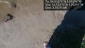
This was a lucky hash, it fell just at the edge of the water...
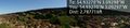
Panorama


Achievements
- Land Geohash