Difference between revisions of "2012-05-26 32 -116"
imported>LucasBrown ([live picture] A bag of chips placed on the hashpoint [http://www.openstreetmap.org/?lat=32.83021073&lon=-116.94364826&zoom=16&layers=B000FTF @32.8302,-116.9436]) |
m |
||
| (10 intermediate revisions by 4 users not shown) | |||
| Line 5: | Line 5: | ||
}} | }} | ||
| − | |||
__NOTOC__ | __NOTOC__ | ||
== Location == | == Location == | ||
| − | |||
East of the end of the 52, in Santee, next to a water tank | East of the end of the 52, in Santee, next to a water tank | ||
== Participants == | == Participants == | ||
| − | + | *[[User:JesseW|JesseW]] (and a drag-along)<br> | |
| − | + | *[[User:LucasBrown|LucasBrown]] Reached the hashpoint at 16:15-ish (PDT), 2012-05-26 | |
| − | [[User: | + | |
== Plans == | == Plans == | ||
| − | |||
As it's '''Mouse Over Day''', I plan to drive out there and be there at 4 PM; hopefully I can meet some other hashers. [[User:JesseW|JesseW]] 13:54, 25 May 2012 (EDT) | As it's '''Mouse Over Day''', I plan to drive out there and be there at 4 PM; hopefully I can meet some other hashers. [[User:JesseW|JesseW]] 13:54, 25 May 2012 (EDT) | ||
| + | |||
== Expedition == | == Expedition == | ||
| − | + | [[User:JesseW|JesseW]]: Myself and a drag-along drove out in my white Honda Accord, and arrived at the end of the public street, Ocatio St. a few hundred feet from the hash point. We chickened out of knocking on doors and asking if we could walk around behind the houses nearest the hashpoint. | |
| − | |||
| − | |||
== Photos == | == Photos == | ||
| − | + | ||
| − | |||
| − | |||
<gallery perrow="5"> | <gallery perrow="5"> | ||
| + | Image:2012-05-26_32_-116_16-23-22-956.jpg | A bag of chips placed on the hashpoint [http://www.openstreetmap.org/?lat=32.83021073&lon=-116.94364826&zoom=16&layers=B000FTF @32.8302,-116.9436] | ||
| − | Image:2012-05-26_32_-116_16- | + | Image:2012-05-26_32_-116_16-24-14-553.jpg | Geohash Droid details page screenshot at the hashpoint [http://www.openstreetmap.org/?lat=32.83021120&lon=-116.94364935&zoom=16&layers=B000FTF @32.8302,-116.9436] |
| + | |||
| + | Image:2012-05-26 32 -116 1 Fancy house.jpg | The hash was in a very fancy neighbourhood. | ||
| + | Image:2012-05-26 32 -116 2 Proof.jpg | Proof of how close [[User:JesseW|JesseW]] (and drag-along) got. | ||
| + | Image:2012-05-26 32 -116 3 Drag_along.jpg | [[User:JesseW|JesseW]]'s drag-along (on their first geohash trip!) | ||
| + | Image:2012-05-26 32 -116 4 Me.jpg | [[User:JesseW|JesseW]] as close as we could legally park. | ||
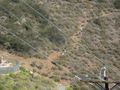
| + | Image:2012-05-26 32 -116 5 Overall view.jpg | A good overall view of the hash point, from a dead-end street some distance away. | ||
| + | Image:2012-05-26 32 -116 6 Rattlesnake sign.jpg | The first of two signs that deterred [[User:JesseW|JesseW]]'s party from continuing further. | ||
| + | Image:2012-05-26 32 -116 7 No Trespassing.jpg | The other sign that deterred us. | ||
| + | Image:2012-05-26 32 -116 8 People by the hash.jpg | There were some people that were walking by the hash while we were there -- maybe Lucas, maybe random neighbours. | ||
</gallery> | </gallery> | ||
== Achievements == | == Achievements == | ||
{{#vardefine:ribbonwidth|800px}} | {{#vardefine:ribbonwidth|800px}} | ||
| − | + | {{No trespassing |latitude=32 |longitude=-116 |date=2012-05-26 |image=2012-05-26 32 -116 7 No Trespassing.jpg |name= [[User:JesseW|JesseW]]}} | |
| − | |||
| − | |||
| − | |||
| − | |||
| − | |||
| − | |||
| − | [[ | ||
| − | |||
[[Category:Expeditions]] | [[Category:Expeditions]] | ||
| − | |||
[[Category:Expeditions with photos]] | [[Category:Expeditions with photos]] | ||
| − | [[Category: | + | <!--[[Category:Coordinates not reached]] |
| − | [[Category: | + | [[Category:Not reached - No public access]]--> |
| − | --> | ||
| − | |||
| − | |||
[[Category:Coordinates reached]] | [[Category:Coordinates reached]] | ||
| − | -- | + | <!-- |
| + | Eldin: I'm including both category:coordinates reached and category:coordinates not reached, because 2 separate groups made the attempt. 1 claimed success while the other claimed no trespassing | ||
| − | + | Fippe: If at least one party reached the coordinates, the expedition should not be in "Coordinates not reached". | |
| − | |||
| − | |||
| − | |||
| − | |||
| − | |||
| − | |||
--> | --> | ||
| + | {{location|US|CA|SD}} | ||
Latest revision as of 09:32, 16 March 2022
| Sat 26 May 2012 in 32,-116: 32.8302435, -116.9436386 geohashing.info google osm bing/os kml crox |
Location
East of the end of the 52, in Santee, next to a water tank
Participants
- JesseW (and a drag-along)
- LucasBrown Reached the hashpoint at 16:15-ish (PDT), 2012-05-26
Plans
As it's Mouse Over Day, I plan to drive out there and be there at 4 PM; hopefully I can meet some other hashers. JesseW 13:54, 25 May 2012 (EDT)
Expedition
JesseW: Myself and a drag-along drove out in my white Honda Accord, and arrived at the end of the public street, Ocatio St. a few hundred feet from the hash point. We chickened out of knocking on doors and asking if we could walk around behind the houses nearest the hashpoint.
Photos
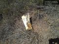
A bag of chips placed on the hashpoint @32.8302,-116.9436
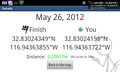
Geohash Droid details page screenshot at the hashpoint @32.8302,-116.9436
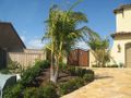
The hash was in a very fancy neighbourhood.
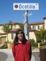
Proof of how close JesseW (and drag-along) got.
JesseW's drag-along (on their first geohash trip!)
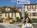
JesseW as close as we could legally park.
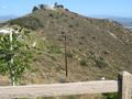
A good overall view of the hash point, from a dead-end street some distance away.
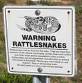
The first of two signs that deterred JesseW's party from continuing further.
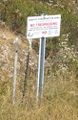
The other sign that deterred us.
There were some people that were walking by the hash while we were there -- maybe Lucas, maybe random neighbours.


Achievements
JesseW earned the No trespassing consolation prize
|