Difference between revisions of "2012-05-27 52 5"
imported>Eupeodes (specified map on which a track was missing) |
imported>Eupeodes m (→Eupeodes) |
||
| Line 13: | Line 13: | ||
== The Expedition == | == The Expedition == | ||
=== Eupeodes === | === Eupeodes === | ||
| − | Around three in the afternoon | + | Around three in the afternoon Eupeodes decided to go for this hash which seemed to be an easy one close to home. When he got there it appeared much more difficult to reach. At first he stumbled on a barbwire fence at only 200 meters from the hashpoint. At this point he considered giving up but luckily he decided to try to reach the point from the other side. This worked out and the nicest part was that the point turned out te be almost on a track which was not on the map (google), at home he found out that the track was on OpenStreetMap. He could even cycle on it (which appeared to be allowed in the whole area. Unfortunately a branch got stuk in his rear wheel resulting in a broken mudguard. But at least he made it to the hashpoint so now he has the [[Bicycle Geohash]] and the [[Land geohash achievement]]. |
== Photos == | == Photos == | ||
Revision as of 18:30, 9 June 2012
| Sun 27 May 2012 in 52,5: 52.0161098, 5.6978975 geohashing.info google osm bing/os kml crox |
Location
The geohash is in a forest between Ede and Bennekom
Who went
Eupeodes - by recumbent bike.
The Expedition
Eupeodes
Around three in the afternoon Eupeodes decided to go for this hash which seemed to be an easy one close to home. When he got there it appeared much more difficult to reach. At first he stumbled on a barbwire fence at only 200 meters from the hashpoint. At this point he considered giving up but luckily he decided to try to reach the point from the other side. This worked out and the nicest part was that the point turned out te be almost on a track which was not on the map (google), at home he found out that the track was on OpenStreetMap. He could even cycle on it (which appeared to be allowed in the whole area. Unfortunately a branch got stuk in his rear wheel resulting in a broken mudguard. But at least he made it to the hashpoint so now he has the Bicycle Geohash and the Land geohash achievement.
Photos
Eupeodes
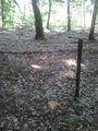
The fence
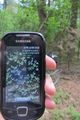
The proof
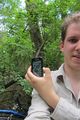
Me and the proof
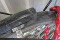
Damage to my bike


Achievements
Eupeodes
Eupeodes earned the Bicycle geohash achievement
|
Eupeodes earned the Land geohash achievement
|