Difference between revisions of "2012-05-29 34 135"
From Geohashing
imported>TdL |
m (per Renaming Proposal) |
||
| (6 intermediate revisions by 2 users not shown) | |||
| Line 14: | Line 14: | ||
== Expedition== | == Expedition== | ||
| − | started about 7km east of the destination (as the crow flies) and | + | started about 7km east of the destination (as the crow flies) and took me about one hour to get there by bicycle (took a bit longer cause i got lost (no GPS device available)). on the way: highways, ricefields, the local headquarters of the japanese self-defense forces and the usual scenery of an industrialized country. at the target point: the warehouse of a tomato farmer in the middle of nowhere (nishiimoarai - no idea what that's supposed to be - a conglomeration of houses between oyamazaki's and kumiyama's city limits i guess). nice trip though, all in all. |
== Photos == | == Photos == | ||
<Gallery> | <Gallery> | ||
| − | File: | + | File:2012-05-29_34_135-rice fields.JPG|rice fields |
| − | File: | + | File:2012-05-29_34_135-sunset.JPG|sunset |
| − | File: | + | File:2012-05-29_34_135-tomato farmer.JPG|tomato farmer |
| − | File: | + | File:2012-05-29_34_135-hash point and bicycle.JPG|hash point and bicycle |
| + | File:2012-05-29_34_135-highways.JPG|directions | ||
| + | File:2012-05-29_34_135-way2.jpg|google is my friend | ||
</Gallery> | </Gallery> | ||
== Achievements == | == Achievements == | ||
| − | {{ | + | {{Graticule unlocked |
| latitude = 34 | | latitude = 34 | ||
| Line 61: | Line 63: | ||
[[Category:Coordinates reached]] | [[Category:Coordinates reached]] | ||
[[Category:Expeditions with photos]] | [[Category:Expeditions with photos]] | ||
| + | {{location|JP|26}} | ||
Latest revision as of 05:37, 20 March 2024
| Tue 29 May 2012 in 34,135: 34.9017148, 135.7322438 geohashing.info google osm bing/os kml crox |
Location
nishiimoarai in kumiyama city, kyoto prefecture, JAPAN
Participants
Expedition
started about 7km east of the destination (as the crow flies) and took me about one hour to get there by bicycle (took a bit longer cause i got lost (no GPS device available)). on the way: highways, ricefields, the local headquarters of the japanese self-defense forces and the usual scenery of an industrialized country. at the target point: the warehouse of a tomato farmer in the middle of nowhere (nishiimoarai - no idea what that's supposed to be - a conglomeration of houses between oyamazaki's and kumiyama's city limits i guess). nice trip though, all in all.
Photos
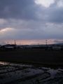
rice fields
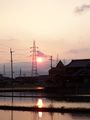
sunset
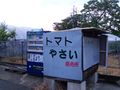
tomato farmer
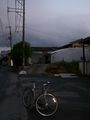
hash point and bicycle
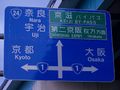
directions
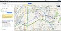
google is my friend


Achievements
TdL earned the Graticule Unlocked Achievement
|
TdL earned the No Batteries Geohash Achievement
|
TdL earned the Bicycle geohash achievement
|