Difference between revisions of "2012-06-04 48 7"
From Geohashing
imported>Frizzy (→Achievements: }) |
imported>FippeBot m (Location) |
||
| (4 intermediate revisions by 2 users not shown) | |||
| Line 1: | Line 1: | ||
| − | |||
| − | |||
| − | |||
| − | |||
| − | |||
| − | |||
| − | |||
| − | |||
| − | |||
| − | |||
{{meetup graticule | {{meetup graticule | ||
| lat=48 | | lat=48 | ||
| Line 15: | Line 5: | ||
}} | }} | ||
| − | |||
__NOTOC__ | __NOTOC__ | ||
== Location == | == Location == | ||
| Line 29: | Line 18: | ||
== Plans == | == Plans == | ||
| − | |||
;Frizzy: Is going to start the expedition after uni at around 17. | ;Frizzy: Is going to start the expedition after uni at around 17. | ||
| Line 35: | Line 23: | ||
== Expedition == | == Expedition == | ||
| − | |||
| − | |||
;Frizzy: | ;Frizzy: | ||
*I am starting the expedition now though rainy and stormy weather :-) -- [[User:Frizzy|Frizzy]] [http://www.openstreetmap.org/?lat=48.00261967&lon=7.85005976&zoom=16&layers=B000FTF @48.0026,7.8501] 17:23, 4 June 2012 (GMT+02:00) | *I am starting the expedition now though rainy and stormy weather :-) -- [[User:Frizzy|Frizzy]] [http://www.openstreetmap.org/?lat=48.00261967&lon=7.85005976&zoom=16&layers=B000FTF @48.0026,7.8501] 17:23, 4 June 2012 (GMT+02:00) | ||
| Line 44: | Line 30: | ||
;Hijackal | ;Hijackal | ||
: Still on IRC at 17:51, Hijackal sees that Frizzy has already crossed the Dreisam ([[:File:2012-06-04 48 7 17-42-38-863.jpg|live pic]]), so he leaves his office immediately and gets on his way. Making good progress and avoiding wind and rain, he arrives in hash forest in 20 minutes. Circling the hash site on bike trails, he sees no other bike, so he has somehow managed to pass Frizzy. She was probably confused by her Android. | : Still on IRC at 17:51, Hijackal sees that Frizzy has already crossed the Dreisam ([[:File:2012-06-04 48 7 17-42-38-863.jpg|live pic]]), so he leaves his office immediately and gets on his way. Making good progress and avoiding wind and rain, he arrives in hash forest in 20 minutes. Circling the hash site on bike trails, he sees no other bike, so he has somehow managed to pass Frizzy. She was probably confused by her Android. | ||
| − | : Hijackal attempts to reach the hash by a trail left by some motorized vehicle in years past, but that soon ends in a swamp with over 60 m to go, so he turns around, hoping to be more successful | + | : Hijackal attempts to reach the hash by a trail left by some motorized vehicle in years past, but that soon ends in a swamp with over 60 m to go, so he turns around, hoping to be more successful one of the other unmapped trails he had seen circling the hash. This time, there is another bike at the beginning of one of the other possible approaches. This path is much better, and Hijackal soon sees something blue through the trees - this must be Frizzy! |
: She is hesitating at the fringe of the swamp, but this part of the forest is much better than Hijackals first attempt, only 15 m of swamp to go. Luckily, a fallen tree bridges a deeper, completely liquid part of the swamp, and the two hashers are soon within 3 m of the hash, surrounded by huge mosquitoes. GPS accuracy is bad, so this is declared sufficient. Hasty pictures are taken, and the two happy hashers flee the clouds of thirsty mosquitoes. | : She is hesitating at the fringe of the swamp, but this part of the forest is much better than Hijackals first attempt, only 15 m of swamp to go. Luckily, a fallen tree bridges a deeper, completely liquid part of the swamp, and the two hashers are soon within 3 m of the hash, surrounded by huge mosquitoes. GPS accuracy is bad, so this is declared sufficient. Hasty pictures are taken, and the two happy hashers flee the clouds of thirsty mosquitoes. | ||
: The ride back is uneventful and efficient. Lovely countryside, threatening weather - luckily, everyone arrives home feeling only wind, not rain. | : The ride back is uneventful and efficient. Lovely countryside, threatening weather - luckily, everyone arrives home feeling only wind, not rain. | ||
| + | |||
| + | ; P.S. | ||
| + | : Later, a tick is found on an unnamed part of an unnamed hashers body. It is removed, and starts walking around about five minutes after recovering from the initial shock. This probably means enough of the tick was removed. :) | ||
| + | |||
| + | [[Category:Expeditions with ticks]] | ||
== Tracklog == | == Tracklog == | ||
| Line 52: | Line 43: | ||
== Photos == | == Photos == | ||
| − | |||
| − | |||
| − | |||
<gallery perrow="5"> | <gallery perrow="5"> | ||
| Line 66: | Line 54: | ||
Image:2012-06-04_48_7_stupidgrin.jpg | Stupid grin! | Image:2012-06-04_48_7_stupidgrin.jpg | Stupid grin! | ||
| + | |||
| + | Image:2012-06-04_48_7_frizzdroid.jpg | Waiting for the internet. Or for the next mosquito to bite... | ||
| + | |||
| + | Image:2012-06-04_48_7_gps.jpg | Hm, the GPS is pretty badly out of focus. Excuse: Holding still for a picture also meant holding still for the mosquitoes. | ||
</gallery> | </gallery> | ||
| Line 77: | Line 69: | ||
| − | |||
| − | |||
| − | |||
| − | |||
| − | |||
| − | |||
| − | |||
| − | |||
| − | |||
[[Category:Expeditions]] | [[Category:Expeditions]] | ||
| − | + | ||
| − | |||
| − | |||
| − | |||
| − | |||
| − | |||
| − | |||
[[Category:Coordinates reached]] | [[Category:Coordinates reached]] | ||
| − | + | {{location|DE|BW|FR}} | |
| − | |||
| − | |||
| − | |||
| − | |||
| − | |||
| − | |||
| − | |||
| − | |||
| − | |||
Latest revision as of 04:22, 13 August 2019
| Mon 4 Jun 2012 in 48,7: 48.0458348, 7.7443343 geohashing.info google osm bing/os kml crox |
Location
In a forest near Gottenheim.
Participants
Plans
- Frizzy
- Is going to start the expedition after uni at around 17.
- Hijackal
- Will try to leave work by bike at 18:00, which would result in arrival at the hash at about 18:45
Expedition
- Frizzy
- I am starting the expedition now though rainy and stormy weather :-) -- Frizzy @48.0026,7.8501 17:23, 4 June 2012 (GMT+02:00)
- Fortunately the weather turned out to be sunny again and I had a nice bike ride along the Dreisam, through Umkirch and later through a forest to the hash. The microcoordination was a bit tricky because the ways through the forest were very strange...But finally I found a good place to park my bike besides a path and started to walk into the forest. I had just about 200 meters to go. First the way was very nice and dry and not with much bushes and easily to handle. But when there were 40 meters to go, I had to stop in front of a swamp with a lot of mosquitos. Then I heard a loud *clack*...
- [Unfortunately my internet-connection broke in the forest, so I wasn't able to upload the other pictures from the hash site.]
- Hijackal
- Still on IRC at 17:51, Hijackal sees that Frizzy has already crossed the Dreisam (live pic), so he leaves his office immediately and gets on his way. Making good progress and avoiding wind and rain, he arrives in hash forest in 20 minutes. Circling the hash site on bike trails, he sees no other bike, so he has somehow managed to pass Frizzy. She was probably confused by her Android.
- Hijackal attempts to reach the hash by a trail left by some motorized vehicle in years past, but that soon ends in a swamp with over 60 m to go, so he turns around, hoping to be more successful one of the other unmapped trails he had seen circling the hash. This time, there is another bike at the beginning of one of the other possible approaches. This path is much better, and Hijackal soon sees something blue through the trees - this must be Frizzy!
- She is hesitating at the fringe of the swamp, but this part of the forest is much better than Hijackals first attempt, only 15 m of swamp to go. Luckily, a fallen tree bridges a deeper, completely liquid part of the swamp, and the two hashers are soon within 3 m of the hash, surrounded by huge mosquitoes. GPS accuracy is bad, so this is declared sufficient. Hasty pictures are taken, and the two happy hashers flee the clouds of thirsty mosquitoes.
- The ride back is uneventful and efficient. Lovely countryside, threatening weather - luckily, everyone arrives home feeling only wind, not rain.
- P.S.
- Later, a tick is found on an unnamed part of an unnamed hashers body. It is removed, and starts walking around about five minutes after recovering from the initial shock. This probably means enough of the tick was removed. :)
Tracklog
Photos
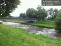
Dreisam river on my way to the hash. @48.0172,7.7981

Frizzy + bike... @48.0221,7.7940
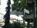
...on their way to Gottenheim. @48.0362,7.7617
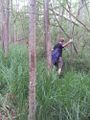
Hijackal in the swamp full of mosquitos!

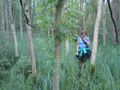
Stupid grin!
Waiting for the internet. Or for the next mosquito to bite...
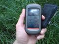
Hm, the GPS is pretty badly out of focus. Excuse: Holding still for a picture also meant holding still for the mosquitoes.


Achievements
Frizzy and Hijackal earned the Bicycle geohash achievement
|
Frizzy and Hijackal earned the Land geohash achievement
|