Difference between revisions of "2012-06-04 51 -1"
imported>Jand (→Gallery) |
imported>Jand |
||
| Line 43: | Line 43: | ||
| count = 2 | latitude = 51 | longitude = -1 | date = 2012-06-03 | Jand | | count = 2 | latitude = 51 | longitude = -1 | date = 2012-06-03 | Jand | ||
}} | }} | ||
| + | |||
| + | == If you were lead here by my hash marker... == | ||
Revision as of 18:27, 4 June 2012
| Mon 4 Jun 2012 in 51,-1: 51.0458348, -1.7443343 geohashing.info google osm bing/os kml crox |
Contents
Location
The hash was located on a tree/grassland border slightly downhill of The Green Dragon, Alderbury.
Expedition
My dad, my brother Ed and I set off for today's hash at 12:45, taking the same route as I did for 2012-05-27 51 -1. I do suspect that Ed only came along as today was the site of a Pub Geohash.
We arrived at The Green Dragon public house at just after 1 o clock and from there it was a simple walk of around 120m down to the hash, (on the downside it was quite damp due to the previous night's rain). Ed and I reached the hash at 1:04, which was mercifully 2m short of a large amount of stinging nettles. We then headed back up to the pub to get our achievement! I left my hash marker on a telegraph pole on the road.
Fun fact: Apparently at the very table at which we sat, in 1963 my Dad had Salt and Vinegar crisps for the very first time. Will the fun ever end? :O
Gallery

Coordinates reached
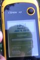
Time and date

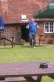
Me at the hash
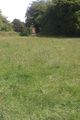
The Green Dragon is just visible from the hash
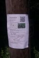
Our hash marker on a roadside telegraph pole
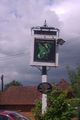
The sign of The Green Dragon
My brother Ed at the Pubhash

Finally, my Pubhash drink!


Achievement
Jand earned the Pub Geohash Achievement
|
Jand earned the Drag-along achievement
|
This user earned the Consecutive geohash achievement
|