Difference between revisions of "2012-06-05 52 5"
imported>Murfie (→Photos) |
imported>FippeBot m (Location) |
||
| (4 intermediate revisions by 2 users not shown) | |||
| Line 1: | Line 1: | ||
| − | |||
<!-- If you did not specify these parameters in the template, please substitute appropriate values for IMAGE, LAT, LON, and DATE (YYYY-MM-DD format) | <!-- If you did not specify these parameters in the template, please substitute appropriate values for IMAGE, LAT, LON, and DATE (YYYY-MM-DD format) | ||
| Line 15: | Line 14: | ||
}} | }} | ||
| − | + | ||
__NOTOC__ | __NOTOC__ | ||
== Location == | == Location == | ||
| − | + | ||
near the Groote Meer in Naarden | near the Groote Meer in Naarden | ||
== Participants == | == Participants == | ||
| − | + | ||
| − | |||
[[User:Murfie|Murfie]] | [[User:Murfie|Murfie]] | ||
== Plans == | == Plans == | ||
| − | + | ||
Go there after work, only 20 minutes drive and probably 5 minutes walk. | Go there after work, only 20 minutes drive and probably 5 minutes walk. | ||
== Expedition == | == Expedition == | ||
| − | |||
| Line 90: | Line 87: | ||
And dense vegetation it is. A lot of thorn bushes. MOSQUITO'S. | And dense vegetation it is. A lot of thorn bushes. MOSQUITO'S. | ||
| − | not 1. not 100. No, a zillion. A swamp. | + | not 1. not 100. No, a zillion. A swamp. Scratches on my legs everywhere. |
Wait, these are the clothes I wear at work. My shiny shoes, my clean | Wait, these are the clothes I wear at work. My shiny shoes, my clean | ||
trousers, argh. Ok very close now, only 10m. But now it's really | trousers, argh. Ok very close now, only 10m. But now it's really | ||
| Line 96: | Line 93: | ||
Jump, step, jump. Wheeh. Yes. I reached it. I can almost see the | Jump, step, jump. Wheeh. Yes. I reached it. I can almost see the | ||
lake again. Wait, what's that standing there exactly at the geohash | lake again. Wait, what's that standing there exactly at the geohash | ||
| − | spot? It 's some kind of bird on a stick! Gross! | + | spot? It's some kind of bird on a stick! Gross! |
Did somebody else leave this here earlier today? No, it looks too | Did somebody else leave this here earlier today? No, it looks too | ||
weathered for that. I climb back my way through the vegetation. | weathered for that. I climb back my way through the vegetation. | ||
| Line 106: | Line 103: | ||
== Photos == | == Photos == | ||
| − | + | ||
| − | |||
| − | |||
<gallery perrow="5"> | <gallery perrow="5"> | ||
Image:2012-06-05_52_5_0336.jpg|car navigation sent me here | Image:2012-06-05_52_5_0336.jpg|car navigation sent me here | ||
| Line 133: | Line 128: | ||
== Achievements == | == Achievements == | ||
{{#vardefine:ribbonwidth|800px}} | {{#vardefine:ribbonwidth|800px}} | ||
| − | |||
| + | {{Land geohash | latitude = 52 | longitude = 4 | date = 2012-06-03 | name = Murfie }} | ||
| − | + | {{consecutive geohash | count = 3 | latitude = 52 | longitude = 4 | date = 2012-06-03 | name = Murfie }} | |
| − | |||
| − | |||
| − | + | {{Minesweeper geohash | graticule = Utrecht, Netherlands | ranknumber = 2 | w = true | nw = true | name = Murfie }} | |
| − | |||
| − | |||
| − | |||
| − | |||
[[Category:Expeditions]] | [[Category:Expeditions]] | ||
| − | + | ||
[[Category:Expeditions with photos]] | [[Category:Expeditions with photos]] | ||
| − | |||
| − | |||
| − | |||
| − | |||
| − | |||
[[Category:Coordinates reached]] | [[Category:Coordinates reached]] | ||
| − | + | {{location|NL|NH}} | |
| − | |||
| − | |||
| − | |||
| − | |||
| − | |||
| − | |||
| − | |||
| − | |||
| − | |||
Latest revision as of 04:24, 13 August 2019
| Tue 5 Jun 2012 in 52,5: 52.3015895, 5.1208696 geohashing.info google osm bing/os kml crox |
Location
near the Groote Meer in Naarden
Participants
Plans
Go there after work, only 20 minutes drive and probably 5 minutes walk.
Expedition
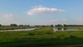
Shall I do it, or not? It's 20 minutes by car, but there are traffic jams during this hour. So it could easily take an hour to reach Naarden and then find somewhere to park and then walk to the geohash. Ok, let's see on Google maps how reachable is it anyway? There seems to be a bike path near the geohash. Or maybe even a car can go there, although there's no streetview available for it. So let's assume I can't drive there. Then I have to park somewhere near the crossing of the bike path and the road leading up to it. Ok let's do it.
5 minutes in my car. Oh yes, first traffic jam. Along the rest the route also some jams. Finally arriving in Naarden finding the way to the Groote Meer. Car navigation says turn left onto this sand/rock path. My feeling says no, but still I obey the navigator. It's a dead end and I have to return (and turning around is hard).
Ok, found another way which I'm supposed to take. This one looks better. Guess what, no driving allowed after 19 o'clock. What's the time? 18:50. That would be a close call. I'd really have to hurry to make it within 10 minutes from here. And I'm doing this for a hobby and if I want stress I will go to my work. So let's make a detour and find another road nearby.
Good, I find one leading up to the bike path I saw earlier on Google maps. However, there's no crossing where I expect it. The roads are parallel, but separated by water. So I can not get out here and step over to the bike path. I'll have to drive back and park from where the bike path is reachable. Which I do. I park my car and the GPS says now I'm 1.5km away from the geohash. Only 15 minutes walk and the weather is fantastic. Although I haven't had supper yet and feel a bit peckish, I decide to go for an evening walk.
The bike path is actually not a bike path but for pedestrians only. You are not allowed to ride a bike on this path, not allowed to ride a horse and not even ride on a dog's back here. See signs.
After 10 minutes of walking, I see some large note displayed telling me what kind of nature I find myself in. I decide to make a picture of the display and read it later. There are probably rules on it which tell me I should stay on the path, and that rule will not come in handy when I have to crawl through the woods the last metres. So it's better to hear it afterwards.
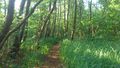
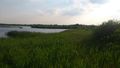
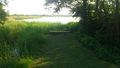
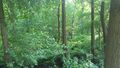
I continue the peaceful walk and see a small path going straight into the forest. I follow the windy path some kind of outpost I can climb onto to view the lake. It's the first view I get from the lake since I entered this area. I see a boat. Nice. There's a sign next to the outpost showing which animals can be seen here. Now I have to make a decision, jump down (no steps on the other side) this outpost and walk through the reed along the coast, or return to the path I was following before (it's called 'Meerkade', btw). The geohash is located very near to the coast, but the reed is high and I don't think it's easy to climb my way back. Therefore I decide to go back to the Meerkade. That means I'll have to crawl the last 100m through some dense vegetation.
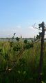
And dense vegetation it is. A lot of thorn bushes. MOSQUITO'S. not 1. not 100. No, a zillion. A swamp. Scratches on my legs everywhere. Wait, these are the clothes I wear at work. My shiny shoes, my clean trousers, argh. Ok very close now, only 10m. But now it's really really dense vegetation. Should I give up? No, one more try. Jump, step, jump. Wheeh. Yes. I reached it. I can almost see the lake again. Wait, what's that standing there exactly at the geohash spot? It's some kind of bird on a stick! Gross! Did somebody else leave this here earlier today? No, it looks too weathered for that. I climb back my way through the vegetation. Still puzzled what this bird is supposed to mean and 1 hour later than expected, I return back home.
Tracklog
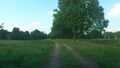
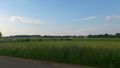
Photos
car navigation sent me here
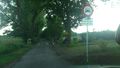
no entrance after 19:00h!
cows
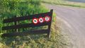
no cycling, horse/dog riding
nice day for a walk
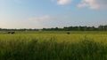
beautiful nature
landscape
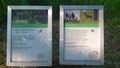
the 'rules' here
path leading up to the outpost
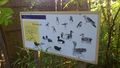
which animals can be seen here
lake view from the outpost
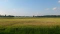
landscape opposite of the road of the geohash
in case you need rest
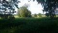
entering the dense vegetation
bird on a stick (wtf)


Achievements
Murfie earned the Land geohash achievement
|
Murfie earned the Consecutive geohash achievement
|
Murfie achieved level 2 of the Minesweeper Geohash achievement
|