Difference between revisions of "2012-06-06 38 -77"
imported>Thomcat m (Basic create) |
imported>FippeBot m (Location) |
||
| (4 intermediate revisions by one other user not shown) | |||
| Line 1: | Line 1: | ||
| − | |||
| − | |||
| − | |||
| − | |||
| − | |||
| − | |||
| − | |||
| − | |||
| − | |||
| − | |||
{{meetup graticule | {{meetup graticule | ||
| lat=38 | | lat=38 | ||
| Line 15: | Line 5: | ||
}} | }} | ||
| − | |||
__NOTOC__ | __NOTOC__ | ||
| − | == Location == | + | == Location == |
| − | + | Along the [http://en.wikipedia.org/wiki/Chesapeake_and_Ohio_Canal_National_Historical_Park Chesapeake and Ohio Canal National Historic Park] just southeast of Chain Bridge road. Google maps satellite shows it to be barren and easy to get to. | |
== Participants == | == Participants == | ||
| − | + | [[User:Thomcat|Thomcat]] | |
| − | |||
== Plans == | == Plans == | ||
| − | + | I put an announcement on the graticule page as soon as the point was visible and started making plans. One train and one bus (go public transit!) and I would be at the hash around 4:00. | |
== Expedition == | == Expedition == | ||
| − | + | This expedition, solo unfortunately, was a case of "not here but down there." I took the blue line train to Farragut Park, then just missed the D5 bus. No problem with the next bus, then south to the Park itself. I took one path way which would lead to the road... no, it led to an overpass. After working my way down from that, I ended up on a bridge over the path I needed to be on. | |
| + | |||
| + | I followed that path to the appropriate spot for yet another "down there" moment - this time into a very green and growing patch of canal park. In I went, hoping this would not lead to the first "Lyme Disease" achievement :P | ||
| + | |||
| + | Much undergrowth was skirted or pushed aside leading me to the spot, a very cool clearing with three big rocks. Said rocks enabled me to prop camera and pose, to spell out XKCD, and in general to wait patiently to see if anyone else was going to show up or post on the graticule page. | ||
| − | + | At 5:30 I gave up and scrambled out a different way than I came in. After hanging out on the path for a bit longer I gave up completely and made my way across the Chain Road Bridge and back into a fairly rural patch of Virginia. Finally I found a bus back to Crystal City and the hotel. | |
| − | + | ||
| + | '''Addendum:''' Researching documented expeditions, this is the '''first''' successful one inside the actual District of Columbia. | ||
== Photos == | == Photos == | ||
| − | <!-- | + | <gallery perrow="4"> |
| − | Image: | + | Image:2012_06_06_38_-77_Farragut.jpg|D.C. has plenty of statues to see |
| − | --> | + | Image:2012_06_06_38_-77_von_steuben.jpg|Another D.C. statue, from Lafayette Square |
| − | <gallery perrow=" | + | Image:2012_06_06_38_-77_von_steuben_instruction.jpg|The only military instruction I can see is "Don't point that thing there!" |
| + | Image:2012_06_06_38_-77_D5_bus.jpg|Finally, the D5 bus arrives! | ||
| + | </gallery> | ||
| + | |||
| + | <gallery perrow="3"> | ||
| + | Image:2012_06_06_38_-77_trail.jpg|Off one street, a convenient trail leads the way... | ||
| + | Image:2012_06_06_38_-77_trail_overpass.jpg|... just to this overpass | ||
| + | Image:2012_06_06_38_-77_trail_down_there.jpg|I need to be down there! | ||
| + | </gallery> | ||
| + | |||
| + | <gallery perrow="4"> | ||
| + | Image:2012_06_06_38_-77_bridge.jpg|The trail leads eventually to this old railroad bridge | ||
| + | Image:2012_06_06_38_-77_bridge_down_there.jpg|Again, I need to be down there. | ||
| + | Image:2012_06_06_38_-77_canal_trail.jpg|Finally on the right trail. Well traveled - joggers and cyclists | ||
| + | Image:2012_06_06_38_-77_canal_spillway.jpg|This spillway allows water to overflow from the canal - fortunately it's dry now, so maybe the geohash will be also | ||
| + | </gallery> | ||
| + | |||
| + | <gallery perrow="3"> | ||
| + | Image:2012_06_06_38_-77_milestone.jpg|An older and slightly newer milestone | ||
| + | Image:2012_06_06_38_-77_canal_spot.jpg|Tangentially as close as I can get on trail | ||
| + | Image:2012_06_06_38_-77_canal_down_there.jpg|I've got to go down there?!? | ||
| + | </gallery> | ||
| + | |||
| + | <gallery perrow="4"> | ||
| + | Image:2012_06_06_38_-77_destination.jpg|Destination reached! | ||
| + | Image:2012_06_06_38_-77_two_rocks.jpg|Zooming out, here are two of the three rocks | ||
| + | Image:2012_06_06_38_-77_more_rocks.jpg|More rocks - this is a right nice clearing | ||
| + | Image:2012_06_06_38_-77_on_the_spot.jpg|Pretty much on the spot - huzzah! | ||
| + | </gallery> | ||
| + | |||
| + | <gallery perrow="4"> | ||
| + | Image:2012_06_06_38_-77_xkcd.jpg|Left an XKCD for future visitors... or the wind | ||
| + | Image:2012_06_06_38_-77_chain_bridge.jpg|Climbed up to the Chain Road bridge | ||
| + | Image:2012_06_06_38_-77_canal_view.jpg|Nice view from the bridge | ||
| + | Image:2012_06_06_38_-77_virginia.jpg|Virginia is for lovers... of graffiti | ||
</gallery> | </gallery> | ||
| Line 45: | Line 72: | ||
| − | |||
| − | |||
| − | |||
| − | |||
| − | |||
| − | |||
| − | |||
| − | |||
| − | |||
| − | |||
[[Category:Expeditions]] | [[Category:Expeditions]] | ||
| − | |||
[[Category:Expeditions with photos]] | [[Category:Expeditions with photos]] | ||
| − | |||
| − | |||
| − | |||
| − | |||
| − | |||
[[Category:Coordinates reached]] | [[Category:Coordinates reached]] | ||
| − | + | {{location|US|DC}} | |
| − | |||
| − | |||
| − | |||
| − | |||
| − | |||
| − | |||
| − | |||
| − | |||
| − | |||
Latest revision as of 04:25, 13 August 2019
| Wed 6 Jun 2012 in 38,-77: 38.9283575, -77.1117727 geohashing.info google osm bing/os kml crox |
Location
Along the Chesapeake and Ohio Canal National Historic Park just southeast of Chain Bridge road. Google maps satellite shows it to be barren and easy to get to.
Participants
Plans
I put an announcement on the graticule page as soon as the point was visible and started making plans. One train and one bus (go public transit!) and I would be at the hash around 4:00.
Expedition
This expedition, solo unfortunately, was a case of "not here but down there." I took the blue line train to Farragut Park, then just missed the D5 bus. No problem with the next bus, then south to the Park itself. I took one path way which would lead to the road... no, it led to an overpass. After working my way down from that, I ended up on a bridge over the path I needed to be on.
I followed that path to the appropriate spot for yet another "down there" moment - this time into a very green and growing patch of canal park. In I went, hoping this would not lead to the first "Lyme Disease" achievement :P
Much undergrowth was skirted or pushed aside leading me to the spot, a very cool clearing with three big rocks. Said rocks enabled me to prop camera and pose, to spell out XKCD, and in general to wait patiently to see if anyone else was going to show up or post on the graticule page.
At 5:30 I gave up and scrambled out a different way than I came in. After hanging out on the path for a bit longer I gave up completely and made my way across the Chain Road Bridge and back into a fairly rural patch of Virginia. Finally I found a bus back to Crystal City and the hotel.
Addendum: Researching documented expeditions, this is the first successful one inside the actual District of Columbia.
Photos
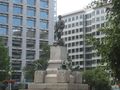
D.C. has plenty of statues to see
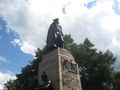
Another D.C. statue, from Lafayette Square
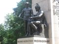
The only military instruction I can see is "Don't point that thing there!"
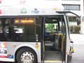
Finally, the D5 bus arrives!


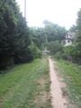
Off one street, a convenient trail leads the way...
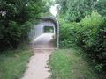
... just to this overpass
I need to be down there!


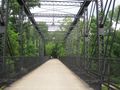
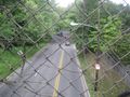
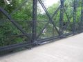
The trail leads eventually to this old railroad bridge
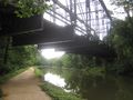
Again, I need to be down there.
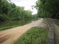
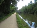
Finally on the right trail. Well traveled - joggers and cyclists
This spillway allows water to overflow from the canal - fortunately it's dry now, so maybe the geohash will be also


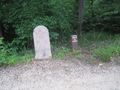
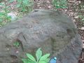
An older and slightly newer milestone
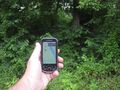
Tangentially as close as I can get on trail
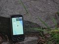
I've got to go down there?!?


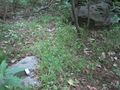
Destination reached!
Zooming out, here are two of the three rocks
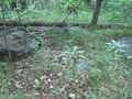
More rocks - this is a right nice clearing
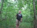
Pretty much on the spot - huzzah!


Left an XKCD for future visitors... or the wind
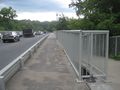
Climbed up to the Chain Road bridge
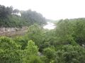
Nice view from the bridge
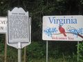
Virginia is for lovers... of graffiti


