Difference between revisions of "2012-06-07 48 7"
imported>Hijackal (planning) |
imported>FippeBot m (Location) |
||
| (3 intermediate revisions by one other user not shown) | |||
| Line 1: | Line 1: | ||
| − | |||
| − | |||
| − | |||
| − | |||
| − | |||
| − | |||
| − | |||
| − | |||
| − | |||
| − | |||
{{meetup graticule | {{meetup graticule | ||
| lat=48 | | lat=48 | ||
| Line 15: | Line 5: | ||
}} | }} | ||
| − | |||
__NOTOC__ | __NOTOC__ | ||
== Location == | == Location == | ||
| − | + | On a field in Neuried, near Offenburg | |
== Participants == | == Participants == | ||
| − | + | [[User:Hijackal|Hijackal]] | |
| − | |||
== Plans == | == Plans == | ||
| − | + | It's a holiday for Hijackal, so rather than do something useful at home, he has loaded three tracks to the hash onto his GPS device, trusting his state's bike [http://www.radroutenplaner-bw.de/ routing tool] to generate today's adventure. The shortest one-way path is about 55 km. | |
== Expedition == | == Expedition == | ||
| − | + | Hijackal got a lazy start, spending lots of time on IRC and deciding what to take. routing is done by [http://www.radroutenplaner-bw.de/] - let's see how good that is. Weather forecast says it might rain later on... | |
| + | |||
| + | By 10, he has left home and is cycling towards the hash. Altogether, the route is well chosen - interestingly, it avoids the "official" designated bicycle paths in some places. | ||
| + | |||
| + | At 13:00, after an uneventful ride, the hash is reached. Deciding to make something of the day, Hijackal doesn't take the shortest way back, but decides to pay the great river Rhine a visit. Shortly after reaching the Rhine, his route (generated by an official government website) takes him past a scary red sign. Of course, the route works out perfectly, the sign seems to be there to be ignored. | ||
| + | |||
| + | The Rhine is lovely as always, but the gravel roads are exhausting at anything above 15 km/h. Also, the wind is picking up and raindrops occasionally threaten bad weather. But instead, the sun comes out, reaching uncomfortable levels, and it gets even windier in the wrong direction, so Hijackal decides to leave the Rhine again and head straight home. | ||
| + | |||
| + | Just before reaching home, he stops in Denzlingen for a great strawberry ice cream. Timing is perfect - as his house comes into view, he hears the first grumbles of an approaching thunderstorm. By the time Hijackal has showered, the outside world is being flooded from above. | ||
| + | |||
| + | After nearly 130 km, about half of that on gravel, Hijackal feels reminded of jet-lag. Consuming unusual amounts of food makes him even tireder, and he falls into two hours of unhealthy sleep before the end of daylight. | ||
== Tracklog == | == Tracklog == | ||
| − | + | [http://www.everytrail.com/view_trip.php?trip_id=1616206 Tracklog] | |
== Photos == | == Photos == | ||
| − | |||
| − | |||
| − | |||
<gallery perrow="5"> | <gallery perrow="5"> | ||
| + | Image:2012-06-08 48 7 gps.jpg | Boring proof. | ||
| + | Image:2012-06-08 48 7 stupid evil grin.jpg | Is it just me, or is one half of that stupid grin more evil than usual? | ||
| + | Image:2012-06-08 48 7 verboten.jpg | Interesting sign. Of course, I followed the red one. | ||
| + | Image:2012-06-08 48 7 gravel rain.jpg | Oh no, raindrops. And gravel makes every km count twice... | ||
| + | Image:2012-06-08 48 7 france.jpg | Hashbike, parts of France, River Rhine. | ||
</gallery> | </gallery> | ||
== Achievements == | == Achievements == | ||
{{#vardefine:ribbonwidth|800px}} | {{#vardefine:ribbonwidth|800px}} | ||
| − | |||
| + | {{land geohash | ||
| + | | latitude = 48 | ||
| + | | longitude = 7 | ||
| + | | date = 2012-06-07 | ||
| + | | name = [[User:Hijackal|Hijackal]] | ||
| + | }} | ||
| + | |||
| + | {{Bicycle geohash | ||
| + | | latitude = 48 | ||
| + | | longitude = 7 | ||
| + | | date = 2012-06-07 | ||
| + | | name = [[User:Hijackal|Hijackal]] | ||
| + | | distance = 129 km | ||
| + | }} | ||
| − | + | {{Circus_geohash | |
| − | + | | latitude = 48 | |
| − | [[ | + | | longitude = 7 |
| + | | date = 2012-06-07 | ||
| + | | name = [[User:Hijackal|Hijackal]] | ||
| + | | performance = juggling clubs | ||
| + | }} | ||
| − | |||
| − | |||
| − | |||
| − | |||
| − | |||
[[Category:Expeditions]] | [[Category:Expeditions]] | ||
| − | + | ||
[[Category:Expeditions with photos]] | [[Category:Expeditions with photos]] | ||
| − | + | ||
| − | |||
| − | |||
| − | |||
| − | |||
[[Category:Coordinates reached]] | [[Category:Coordinates reached]] | ||
| − | + | {{location|DE|BW|OG}} | |
| − | |||
| − | |||
| − | |||
| − | |||
| − | |||
| − | |||
| − | |||
| − | |||
| − | |||
Latest revision as of 04:26, 13 August 2019
| Thu 7 Jun 2012 in 48,7: 48.4590984, 7.8238611 geohashing.info google osm bing/os kml crox |
Location
On a field in Neuried, near Offenburg
Participants
Plans
It's a holiday for Hijackal, so rather than do something useful at home, he has loaded three tracks to the hash onto his GPS device, trusting his state's bike routing tool to generate today's adventure. The shortest one-way path is about 55 km.
Expedition
Hijackal got a lazy start, spending lots of time on IRC and deciding what to take. routing is done by [1] - let's see how good that is. Weather forecast says it might rain later on...
By 10, he has left home and is cycling towards the hash. Altogether, the route is well chosen - interestingly, it avoids the "official" designated bicycle paths in some places.
At 13:00, after an uneventful ride, the hash is reached. Deciding to make something of the day, Hijackal doesn't take the shortest way back, but decides to pay the great river Rhine a visit. Shortly after reaching the Rhine, his route (generated by an official government website) takes him past a scary red sign. Of course, the route works out perfectly, the sign seems to be there to be ignored.
The Rhine is lovely as always, but the gravel roads are exhausting at anything above 15 km/h. Also, the wind is picking up and raindrops occasionally threaten bad weather. But instead, the sun comes out, reaching uncomfortable levels, and it gets even windier in the wrong direction, so Hijackal decides to leave the Rhine again and head straight home.
Just before reaching home, he stops in Denzlingen for a great strawberry ice cream. Timing is perfect - as his house comes into view, he hears the first grumbles of an approaching thunderstorm. By the time Hijackal has showered, the outside world is being flooded from above.
After nearly 130 km, about half of that on gravel, Hijackal feels reminded of jet-lag. Consuming unusual amounts of food makes him even tireder, and he falls into two hours of unhealthy sleep before the end of daylight.
Tracklog
Photos
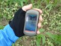
Boring proof.

Is it just me, or is one half of that stupid grin more evil than usual?
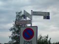
Interesting sign. Of course, I followed the red one.
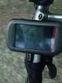
Oh no, raindrops. And gravel makes every km count twice...
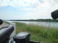
Hashbike, parts of France, River Rhine.


Achievements
Hijackal earned the Land geohash achievement
|
Hijackal earned the Bicycle geohash achievement
|
Hijackal earned the Circus Geohash Achievement
|