Difference between revisions of "2012-06-11 38 -121"
imported>Chandru (Created page with "{{meetup graticule |lat = 38 |lon = -121 |date = 2012-06-11 }} == Location == A random field southeast of Highway 113 at Road 25, just south of Woodland, CA. == Participants ...") |
imported>NWoodruff (→Expedition) |
||
| Line 34: | Line 34: | ||
Image:wilburellis61112.jpg|An ammonia tank thing. | Image:wilburellis61112.jpg|An ammonia tank thing. | ||
Image:field61112.jpg|The field. In the background you can see Highway 113. | Image:field61112.jpg|The field. In the background you can see Highway 113. | ||
| − | Image:flowers61112.jpg|The flowers in the field. What are they? | + | Image:flowers61112.jpg|The flowers in the field. What are they? [http://en.wikipedia.org/wiki/File:Nemophila_menziesii_1.JPG] --~~~~ |
Image:meathashpoint61112.jpg|My first successful geohash! I took 3 pics, this was my best looking one. | Image:meathashpoint61112.jpg|My first successful geohash! I took 3 pics, this was my best looking one. | ||
</gallery> | </gallery> | ||
Revision as of 13:22, 12 June 2012
| Mon 11 Jun 2012 in 38,-121: 38.6293200, -121.7595563 geohashing.info google osm bing/os kml crox |
Location
A random field southeast of Highway 113 at Road 25, just south of Woodland, CA.
Participants
Expedition
It's finals week, I only have 3 days left as a freshman. I found out about geohashing just two months back, but I haven't completed a successful expedition. I want to do one before the academic year ends. However, there's the problem that, well, it's finals week.
I check the coordinate calculator when I wake up, and the hash is 9.6 miles away. I justify this, saying that it's less than 10 miles away, so I can do this reasonably fast.
I decide to leave at 5 PM, as I'm biking and I want it to cool down. It's still hot as heck though. I take Anderson Road north, left on Alvarado, right on Sycamore, then take it as it continues on as CR 100A. Then I turn left on CR 29, right on CR 99 (aka Lake Blvd in Davis and West Street in Woodland), then right on CR 25. I take Road 25 across 113, then take a right on CR 100A. Road 100A goes for about half a mile, then turns into a gravel path. There I had to turn off onto a field of some nice looking flowers and bees.
When I first tried to find it, I completely overshot where I was supposed to turn. So much for the Tron achievement.
To get to the hash location, I had to cross a muddy irrigation ditch thing. Then, I had to walk through the aforementioned field. The ground there was very soft, but I needed to get to that hash.
After reaching within 4.5m of the hash (my GPS accuracy), I decided to go to Woodland to get a carbonated frozen beverage (I know I did this in the wrong order but whatever). It was my first time in Sonic, and I realized that you had to use the drive-thru things even if you walked up. Weird...
Then it got late, so I took the Yolobus 42B back to Davis.
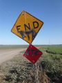
End of the road....
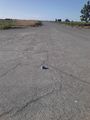
A beer can at the end of the desolate road.
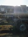
An ammonia tank thing.
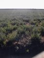
The field. In the background you can see Highway 113.
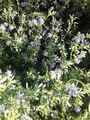
The flowers in the field. What are they? [1] --~~~~

My first successful geohash! I took 3 pics, this was my best looking one.


![[1]](http://en.wikipedia.org/wiki/File:Nemophila_menziesii_1.JPG)