Difference between revisions of "2012-06-19 52 1"
imported>Sourcerer |
imported>FippeBot m (Location) |
||
| (5 intermediate revisions by one other user not shown) | |||
| Line 6: | Line 6: | ||
| graticule_link=Norwich, United Kingdom | | graticule_link=Norwich, United Kingdom | ||
}} | }} | ||
| − | |||
== Location == | == Location == | ||
| + | [[User:Sourcerer|Sourcerer]] failed to reach the hashpoint about 200 metres north west of Haddiscoe railway station on the Norwich to Lowestoft (Norfolk, UK) line and 58 metres south west of the public access road. | ||
== Participants == | == Participants == | ||
[[User:Sourcerer|Sourcerer]] | [[User:Sourcerer|Sourcerer]] | ||
| − | |||
== Plans == | == Plans == | ||
| Line 20: | Line 19: | ||
[[User:Sourcerer|Sourcerer]] expects to be there at about 17:00 to 17:30, making a small diversion off his commute home. He could certainly get to within 70 metres, on a public road, and depending on the livestock or crop in the agricultural field, he might reach the actual point which is on the field edge. | [[User:Sourcerer|Sourcerer]] expects to be there at about 17:00 to 17:30, making a small diversion off his commute home. He could certainly get to within 70 metres, on a public road, and depending on the livestock or crop in the agricultural field, he might reach the actual point which is on the field edge. | ||
| − | == Expedition == | + | == Expedition - Failed == |
| − | |||
| + | The hashpoint could easily have been reached but it would have involved a trespass into a field of rather active bullocks. So it's coordinates not reached, no public access although I got within 56 metres. However it was an interesting location and a pleasant evening to be out and about. A light aircraft flew quite low over the hashpoint. I wonder if his or her report will appear here? The location was close to the railway and river Waveney. All very nice apart from the photo of the car crushed by a train at the rail crossing. | ||
== Photos == | == Photos == | ||
| − | + | <gallery> | |
| − | <gallery | + | Image:2012-06-19 52_1_Sourcerer_1.jpg|Semi-collapsed bridge |
| + | Image:2012-06-19 52_1_Sourcerer_2.jpg|Semi-collapsed bridge | ||
| + | Image:2012-06-19 52_1_Sourcerer_3.jpg|Bullocks | ||
| + | Image:2012-06-19 52_1_Sourcerer_4.jpg|58 Metres Away | ||
| + | Image:2012-06-19 52_1_Sourcerer_5.jpg|Rail crossing landmark | ||
| + | Image:2012-06-19 52_1_Sourcerer_6.jpg|Ouch. Should have gone to Specasvers. | ||
</gallery> | </gallery> | ||
| − | == | + | {{Sourcerer_links |
| + | | prev = 2012-05-31 52 1 | ||
| + | | curr = 2012-06-19 52 1 | ||
| + | | next = 2012-06-22 52 1 | ||
| + | | date = 2012-06-19 | ||
| + | }} | ||
| − | |||
| − | |||
| − | |||
[[Category:Expeditions]] | [[Category:Expeditions]] | ||
| − | |||
[[Category:Expeditions with photos]] | [[Category:Expeditions with photos]] | ||
| − | |||
| − | |||
| − | |||
| − | |||
| − | |||
| − | |||
| − | |||
| − | |||
| − | |||
[[Category:Coordinates not reached]] | [[Category:Coordinates not reached]] | ||
| − | + | [[Category:Not reached - No public access]] | |
| − | + | {{location|GB|ENG|NFK}} | |
| − | [[Category:Not reached - No public access]] | ||
| − | |||
| − | |||
| − | |||
Latest revision as of 04:38, 13 August 2019
| Tue 19 Jun 2012 in Norwich: 52.5300098, 1.6209986 geohashing.info google osm bing/os kml crox |
Contents
Location
Sourcerer failed to reach the hashpoint about 200 metres north west of Haddiscoe railway station on the Norwich to Lowestoft (Norfolk, UK) line and 58 metres south west of the public access road.
Participants
Plans
Sourcerer expects to be there at about 17:00 to 17:30, making a small diversion off his commute home. He could certainly get to within 70 metres, on a public road, and depending on the livestock or crop in the agricultural field, he might reach the actual point which is on the field edge.
Expedition - Failed
The hashpoint could easily have been reached but it would have involved a trespass into a field of rather active bullocks. So it's coordinates not reached, no public access although I got within 56 metres. However it was an interesting location and a pleasant evening to be out and about. A light aircraft flew quite low over the hashpoint. I wonder if his or her report will appear here? The location was close to the railway and river Waveney. All very nice apart from the photo of the car crushed by a train at the rail crossing.
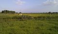
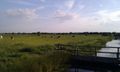
Photos
Semi-collapsed bridge
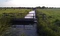
Semi-collapsed bridge
Bullocks
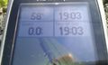
58 Metres Away
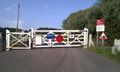
Rail crossing landmark
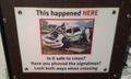
Ouch. Should have gone to Specasvers.


Expeditions and Plans
| 2012-06-19 | ||
|---|---|---|
| Christchurch, New Zealand | ShadowHash | Christchurch, NZ |
| Milano, Italy | Violet Muffles | Treviglio, near Bergamo. |
| Mannheim, Germany | Danatar | in a meadow at Muckensturm, a hamlet belonging to the municipality of Hedde... |
| Norwich, United Kingdom | Sourcerer | Sourcerer failed to reach the hashpoint about 200 metres north west of Hadd... |
Sourcerer's Expedition Links
2012-05-31 52 1 - 2012-06-19 52 1 - 2012-06-22 52 1 - KML file download of Sourcerer's expeditions for use with Google Earth.