Difference between revisions of "2012-06-22 44 -123"
imported>Michael5000 m (→Plans) |
imported>FippeBot m (Location) |
||
| (4 intermediate revisions by one other user not shown) | |||
| Line 1: | Line 1: | ||
| − | |||
| − | |||
| − | |||
| − | |||
| − | |||
| − | |||
| − | |||
| − | |||
| − | |||
| − | |||
{{meetup graticule | {{meetup graticule | ||
| lat=44 | | lat=44 | ||
| Line 27: | Line 17: | ||
== Plans == | == Plans == | ||
| − | [[User:Michael5000|Michael5000]] 01:43, 24 June 2012 (EDT) to Ms. Geni: | + | [[User:Michael5000|Michael5000]] 01:43, 24 June 2012 (EDT) to Ms. Geni, 7:44 a.m. -- |
"So, if you were able to go to this location [link] today (Friday), and send me pictures to prove you'd been there, it would win me bonus points in this weird hobby I've got. | "So, if you were able to go to this location [link] today (Friday), and send me pictures to prove you'd been there, it would win me bonus points in this weird hobby I've got. | ||
| Line 34: | Line 24: | ||
== Expedition == | == Expedition == | ||
| − | |||
| − | + | G, 1:31 p.m.: "Hope this is what you wanted." | |
| − | + | ||
| + | M5K, 1:44 p.m.: "OMG YOU ACTUALLY DID IT. You rock. But then, you knew that." | ||
| + | |||
| + | G, 3:24 p.m.: "Of course I did!! So is what was this all about? Or is it some secret society thing that you have to drive me into the desert blindfolded and threaten my cat in order to keep me silent? Either way, it was fun to do something weird and have no idea why I was doing it!" | ||
== Photos == | == Photos == | ||
| − | |||
| − | |||
| − | |||
<gallery perrow="5"> | <gallery perrow="5"> | ||
| + | File:2012-06-22 44 -123.jpg|I don't know if this is intentional, but while the street sign confirms the location, the actual hashpoint location is in the space shown in the rear view mirror. Neat trick. | ||
</gallery> | </gallery> | ||
== Achievements == | == Achievements == | ||
{{#vardefine:ribbonwidth|800px}} | {{#vardefine:ribbonwidth|800px}} | ||
| − | |||
{{Puppet Master Geohash | {{Puppet Master Geohash | ||
| − | | latitude = | + | | latitude = 44 |
| − | | longitude = | + | | longitude = -123 |
| − | | date = | + | | date = 2012-06-22 |
| − | | puppet = | + | | puppet = The Fabulous Ms. Geni |
| − | | name = | + | | name = [[User:Michael5000|Michael5000]] 01:49, 24 June 2012 (EDT) |
| − | | | ||
}} | }} | ||
| − | |||
| − | |||
| − | |||
| − | |||
| − | |||
| − | |||
| − | |||
| − | |||
| − | |||
| − | |||
[[Category:Expeditions]] | [[Category:Expeditions]] | ||
| − | |||
[[Category:Expeditions with photos]] | [[Category:Expeditions with photos]] | ||
| − | |||
[[Category:Expedition without GPS]] | [[Category:Expedition without GPS]] | ||
| − | |||
| − | |||
| − | |||
[[Category:Coordinates reached]] | [[Category:Coordinates reached]] | ||
| − | + | {{location|US|OR|LE}} | |
| − | |||
| − | |||
| − | |||
| − | |||
| − | |||
| − | |||
| − | |||
| − | |||
| − | |||
Latest revision as of 04:40, 13 August 2019
| Fri 22 Jun 2012 in 44,-123: 44.0454491, -123.1228558 geohashing.info google osm bing/os kml crox |
Location
Between Hayes & Garfield on 13th in Eugene.
Participants
- Michael5000 01:42, 24 June 2012 (EDT) by proxy (The Fabulous Ms. Geni)
Plans
Michael5000 01:43, 24 June 2012 (EDT) to Ms. Geni, 7:44 a.m. --
"So, if you were able to go to this location [link] today (Friday), and send me pictures to prove you'd been there, it would win me bonus points in this weird hobby I've got.
But no pressure."
Expedition
G, 1:31 p.m.: "Hope this is what you wanted."
M5K, 1:44 p.m.: "OMG YOU ACTUALLY DID IT. You rock. But then, you knew that."
G, 3:24 p.m.: "Of course I did!! So is what was this all about? Or is it some secret society thing that you have to drive me into the desert blindfolded and threaten my cat in order to keep me silent? Either way, it was fun to do something weird and have no idea why I was doing it!"
Photos
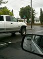
I don't know if this is intentional, but while the street sign confirms the location, the actual hashpoint location is in the space shown in the rear view mirror. Neat trick.

Achievements
Michael5000 01:49, 24 June 2012 (EDT) earned the Puppet Master Geohash achievement
|