Difference between revisions of "2012-06-29 53 6"
imported>Elwingelfje (Created page with "{{subst:Expedition |lat = 53 |lon = 6 |date = 2012-06-29 }}") |
imported>FippeBot m (Location) |
||
| (5 intermediate revisions by 2 users not shown) | |||
| Line 1: | Line 1: | ||
| + | [[Image:{{{image|2012-06-19_53_6_impression.jpg}}}|thumb|left]] | ||
| − | |||
| − | |||
| − | |||
| − | |||
| − | |||
| − | |||
| − | |||
| − | |||
{{meetup graticule | {{meetup graticule | ||
| lat=53 | | lat=53 | ||
| Line 15: | Line 8: | ||
}} | }} | ||
| − | + | ||
__NOTOC__ | __NOTOC__ | ||
== Location == | == Location == | ||
| − | + | Meerstad, the Netherlands | |
== Participants == | == Participants == | ||
| − | + | [[User:Elwingelfje|Elwingelfje]] | |
| − | |||
== Plans == | == Plans == | ||
| − | + | Cycle there in the evening after work; eat a satsuma and some chocolate cookies; get Tron achievement if at all possible. Looks feasible on map. | |
== Expedition == | == Expedition == | ||
| − | |||
| − | + | Apparently I have a talent for not reaching geohashes. I hope I'll get rid of it soon. | |
| − | + | ||
| + | I was wondering about the great amount of ground disturbance and big machines I could see on the google map. There turned out to be a good reason for this: the hash was in the middle of the area known as Meerstad (that would be Lake City in english). "Meerstad" is an area quite near my hometown of Groningen where the municipality develops a project with houses, lakes and new nature. I had never been there before and since it's so new and still in development it was not really on the google map yet. I have to admit, it was quite beautiful in the evening sun, and the earthworks and half-built houses lent it a somewhat surreal air. The trouble with Meerstad is that the idea of living on a flat, watery area in the middle of nowhere doesn't sound very appealing to a lot of people, so house sales are a constant disappointment. Also, mosquitoes. | ||
| + | |||
| + | However, the hash area had apparently been developed already and was now... in the middle of a lake (surprise, surprise!). That was a disappointment to me in its own right :). I got no closer than 100 m or so. I suppose I could have gotten a little nearer on the other side of the lake, but heaps of earth several metres high impeded my advancement. Warnings for quicksand were also issued so I didn't dare stray too far off the path. I think "My kingdom for a boat" is justified here! | ||
| + | |||
| + | There's something else I need to get off my chest here. What is the deal with Dutch rural areas and constant warning and forbidden things signs? Can anyone explain to me? The Netherlands does not appear a dangerous country to me. The land is extremely flat, so no mountain cliffs or ravines. We have no large dangerous predatoric animals (bears, wolves, crocodiles, nope). We do have a lot of water but almost everybody can swim, so that reduces the danger a lot. And yet everytime I go for a walk or a bit of cycling I meet several warning signs that rival each other in how ridiculous they are. I have never seen this in any other country. Theories in the discussion, please :). I've added a few pictures so that you can see what I mean. | ||
== Photos == | == Photos == | ||
| − | + | ||
| − | |||
| − | |||
<gallery perrow="5"> | <gallery perrow="5"> | ||
| + | Image:2012-06-19 53 6 hai there.jpg | The brave geohasher herself | ||
| + | Image:2012-06-19 53 6 oh noes.jpg | See how brave I was? I found a way around this forbidding red barricade, all by myself. It turned out to be perfectly accessible from the other side... | ||
| + | Image:2012-06-19 53 6 ugly.jpg | This is a riding school. The theme here appears to be: how many horse statues can I add to my parking lot? Also, what is that spiky thing in the middle of the round brick thingy? A UFO landing beacon? | ||
| + | Image:2012-06-19 53 6 map.jpg | Map of the Meerstad project; almost all the text says "houses here to be planned at a later stage" which made me a little sad | ||
| + | Image:2012-06-19 53 6 impression.jpg | And this is what it looks like if the Dutch build a suburb | ||
| + | Image:2012-06-19 53 6 impression 2.jpg | Houses at a more finished stage with my bike also somewhere | ||
| + | Image:2012-06-19 53 6 hashpoint.jpg | Hello unreachable hashpoint... it's more or less right in the middle of that water. Bring me a rubber boat pretty please? | ||
| + | Image:2012-06-19 53 6 mosquitoes not nice.jpg | A bench covered in the skins of dead mosquitoes does not make for a very attractive sight. | ||
| + | Image:2012-06-19 53 6 poetry by phone.jpg | If you call this phone number and put the number of the site, a poem about the spot will be read to you. Isn't that neat? | ||
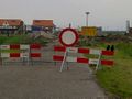
| + | Image:2012-06-19 53 6 tf 2.jpg | This is where the strange signs start. "Suburb under construction", no, really? and then some numbers of regulations and laws without mentioning what this law actually says... | ||
| + | Image:2012-06-19 53 6 srsl tf.jpg | This sign says the following: "Working terrain ground construction Meerstad. Danger of drowning!" A friend of mine remarked about this on facebook: "Of course, if you fell with your head in a puddle and didn't lift it anymore you could totally drown here" which I think says it all. | ||
| + | Image:2012-06-19 53 6 tf.jpg | This one says "Access forbidden. Life endangering terrain." What is behind that levee? I WANT TO KNOW! You see, these signs don't work at all. | ||
</gallery> | </gallery> | ||
== Achievements == | == Achievements == | ||
{{#vardefine:ribbonwidth|800px}} | {{#vardefine:ribbonwidth|800px}} | ||
| − | + | {{My kingdom for a boat | |
| + | | latitude = 53 | ||
| + | | longitude = 6 | ||
| + | | date = 2012-06-29 | ||
| + | | name = elwingelfje | ||
| + | | waterhazard = lake | ||
| + | | image = 2012-06-19 53 6 hashpoint.jpg | ||
| + | }} | ||
| − | |||
| − | |||
| − | |||
| − | |||
| − | |||
| − | |||
| − | |||
| − | |||
| − | |||
| − | |||
[[Category:Expeditions]] | [[Category:Expeditions]] | ||
| − | |||
[[Category:Expeditions with photos]] | [[Category:Expeditions with photos]] | ||
| − | |||
[[Category:Expedition without GPS]] | [[Category:Expedition without GPS]] | ||
| − | |||
| − | |||
| − | |||
| − | |||
| − | |||
| − | |||
| − | |||
[[Category:Coordinates not reached]] | [[Category:Coordinates not reached]] | ||
| − | + | [[Category:Not reached - Mother Nature]] | |
| − | [[Category:Not reached - Mother Nature]] | + | {{location|NL|GR}} |
| − | |||
| − | |||
| − | |||
| − | |||
Latest revision as of 04:48, 13 August 2019

| Fri 29 Jun 2012 in 53,6: 53.2226083, 6.6583566 geohashing.info google osm bing/os kml crox |
Location
Meerstad, the Netherlands
Participants
Plans
Cycle there in the evening after work; eat a satsuma and some chocolate cookies; get Tron achievement if at all possible. Looks feasible on map.
Expedition
Apparently I have a talent for not reaching geohashes. I hope I'll get rid of it soon.
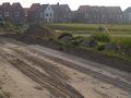
I was wondering about the great amount of ground disturbance and big machines I could see on the google map. There turned out to be a good reason for this: the hash was in the middle of the area known as Meerstad (that would be Lake City in english). "Meerstad" is an area quite near my hometown of Groningen where the municipality develops a project with houses, lakes and new nature. I had never been there before and since it's so new and still in development it was not really on the google map yet. I have to admit, it was quite beautiful in the evening sun, and the earthworks and half-built houses lent it a somewhat surreal air. The trouble with Meerstad is that the idea of living on a flat, watery area in the middle of nowhere doesn't sound very appealing to a lot of people, so house sales are a constant disappointment. Also, mosquitoes.
However, the hash area had apparently been developed already and was now... in the middle of a lake (surprise, surprise!). That was a disappointment to me in its own right :). I got no closer than 100 m or so. I suppose I could have gotten a little nearer on the other side of the lake, but heaps of earth several metres high impeded my advancement. Warnings for quicksand were also issued so I didn't dare stray too far off the path. I think "My kingdom for a boat" is justified here!
There's something else I need to get off my chest here. What is the deal with Dutch rural areas and constant warning and forbidden things signs? Can anyone explain to me? The Netherlands does not appear a dangerous country to me. The land is extremely flat, so no mountain cliffs or ravines. We have no large dangerous predatoric animals (bears, wolves, crocodiles, nope). We do have a lot of water but almost everybody can swim, so that reduces the danger a lot. And yet everytime I go for a walk or a bit of cycling I meet several warning signs that rival each other in how ridiculous they are. I have never seen this in any other country. Theories in the discussion, please :). I've added a few pictures so that you can see what I mean.
Photos

The brave geohasher herself
See how brave I was? I found a way around this forbidding red barricade, all by myself. It turned out to be perfectly accessible from the other side...
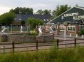
This is a riding school. The theme here appears to be: how many horse statues can I add to my parking lot? Also, what is that spiky thing in the middle of the round brick thingy? A UFO landing beacon?
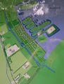
Map of the Meerstad project; almost all the text says "houses here to be planned at a later stage" which made me a little sad
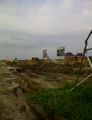
And this is what it looks like if the Dutch build a suburb
Houses at a more finished stage with my bike also somewhere
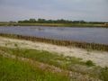
Hello unreachable hashpoint... it's more or less right in the middle of that water. Bring me a rubber boat pretty please?
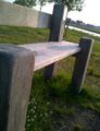
A bench covered in the skins of dead mosquitoes does not make for a very attractive sight.
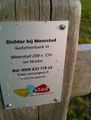
If you call this phone number and put the number of the site, a poem about the spot will be read to you. Isn't that neat?
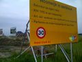
This is where the strange signs start. "Suburb under construction", no, really? and then some numbers of regulations and laws without mentioning what this law actually says...
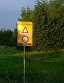
This sign says the following: "Working terrain ground construction Meerstad. Danger of drowning!" A friend of mine remarked about this on facebook: "Of course, if you fell with your head in a puddle and didn't lift it anymore you could totally drown here" which I think says it all.
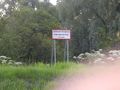
This one says "Access forbidden. Life endangering terrain." What is behind that levee? I WANT TO KNOW! You see, these signs don't work at all.


Achievements
elwingelfje earned the My kingdom for a boat consolation prize
|