Difference between revisions of "2012-06-30 38 -95"
imported>QuantumCop |
imported>FippeBot m (Location) |
||
| (3 intermediate revisions by 2 users not shown) | |||
| Line 14: | Line 14: | ||
}} | }} | ||
| − | |||
__NOTOC__ | __NOTOC__ | ||
== Location == | == Location == | ||
| − | + | ||
On the edge of a field near some train tracks. | On the edge of a field near some train tracks. | ||
== Participants == | == Participants == | ||
| − | + | ||
| − | + | * [[User:QuantumCop|QuantumCop]] | |
| − | [[User:QuantumCop|QuantumCop]] | ||
== Plans == | == Plans == | ||
| Line 34: | Line 32: | ||
== Expedition == | == Expedition == | ||
| − | |||
| − | == Tracklog == | + | |
| − | + | In order to make it to the geohash (about an hour and fifteen minutes away) on time for the leap second, I left my apartment a little before 5:30 PM. As usual, the journey began by taking me south from Lawrence on U.S. 59, then southwest on I-35. I followed my GPS from there, eventually turning down some small gravel roads. Heading towards the geohash, I eventually ran into (not literally) an iron gate with no trespassing signs on it. I thought I might end up having to settle for a No Trespassing consolation prize again, but checking my GPS, it turned out the hash was in the field adjacent to the road I was on, and not on private property. | |
| + | |||
| + | I got out of my car and waded through some relatively thick brush, and before long was in an open field. I walked around a bit, following my GPS, and eventually found the location of the hash. I took some pictures, including my proof and Stupid Grin, and then waited for the leap second. I opened up the GPS clock on my phone and waited until just before 7:00 PM. I don't think the clock on my phone actually showed the leap second itself, which would have been 18:59:60, but I snapped a picture of the clock close enough to that time. Achievement unlocked! Hopefully what proof I was able to provide for it will be sufficient. After getting a couple more pictures, I headed back to my car, turned around, and drove back home, satisfied with my successful geohash. | ||
| + | |||
| + | <!-- == Tracklog == | ||
| + | if your GPS device keeps a log, you may post a link here --> | ||
== Photos == | == Photos == | ||
| − | + | ||
| − | |||
| − | |||
<gallery perrow="5"> | <gallery perrow="5"> | ||
| + | |||
| + | Image:2012-06-30_38_-95_notres.jpg | Looks like I'm walking (and not trespassing) from here. | ||
| + | Image:2012-06-30_38_-95_hash.jpg | The hashpoint is near! | ||
| + | Image:2012-06-30_38_-95_proof.jpg |The proof. | ||
| + | Image:2012-06-30_38_-95_grin.jpg | My stupid grin. | ||
| + | Image:2012-06-30_38_-95_leap.jpg | Proof of the leap second. | ||
| + | Image:2012-06-30_38_-95_noroad.jpg | A road sign with no road. | ||
| + | Image:2012-06-30_38_-95_noroad2.jpg |The other side of the road from the road sign. | ||
| + | Image:2012-06-30_38_-95_reactor.jpg | A nuclear reactor. | ||
| + | |||
</gallery> | </gallery> | ||
| Line 50: | Line 60: | ||
<!-- Add any achievement ribbons you earned below, or remove this section --> | <!-- Add any achievement ribbons you earned below, or remove this section --> | ||
| + | {{gratuitous ribbon | ||
| + | |||
| + | | color = #006200 | ||
| + | | icon = Leap.png | ||
| + | | latitude = 38 | ||
| + | | longitude = -95 | ||
| + | | date = 2012-06-30 | ||
| + | | achievement = Leap geohash achievement 2012 | ||
| + | | description = being at the hashpoint during a leap second for the | ||
| + | | name = QuantumCop | ||
| + | |||
| + | }} | ||
| − | + | * Land Geohash | |
| − | |||
| − | |||
| − | |||
| − | |||
| − | |||
| − | |||
[[Category:Expeditions]] | [[Category:Expeditions]] | ||
| − | + | ||
[[Category:Expeditions with photos]] | [[Category:Expeditions with photos]] | ||
| − | [[Category:Expeditions with videos]] | + | |
| − | + | <!--[[Category:Expeditions with videos]]--> | |
| − | --> | ||
| − | + | ||
[[Category:Coordinates reached]] | [[Category:Coordinates reached]] | ||
| − | |||
| − | + | [[Category:Leap geohash achievement]] | |
| − | + | {{location|US|KS|CF}} | |
| − | |||
| − | [[Category: | ||
| − | |||
| − | |||
| − | |||
| − | |||
Latest revision as of 04:57, 6 August 2019
| Sat 30 Jun 2012 in 38,-95: 38.2420946, -95.6615016 geohashing.info google osm bing/os kml crox |
Location
On the edge of a field near some train tracks.
Participants
Plans
QuantumCop
This geohash (along with all those active at this same time) should provide a good opportunity for earning a Leap Geohash achievement, as there is going to be a leap second on this day. Since the leap second will be at 23:59:60 UTC, that means that I plan to arrive at the geohash no later than about 18:45 CDT, since CDT is UTC-5:00. I will not be making it for the official 4:00 meetup, since I live about an hour and a half drive from this spot.
Expedition
In order to make it to the geohash (about an hour and fifteen minutes away) on time for the leap second, I left my apartment a little before 5:30 PM. As usual, the journey began by taking me south from Lawrence on U.S. 59, then southwest on I-35. I followed my GPS from there, eventually turning down some small gravel roads. Heading towards the geohash, I eventually ran into (not literally) an iron gate with no trespassing signs on it. I thought I might end up having to settle for a No Trespassing consolation prize again, but checking my GPS, it turned out the hash was in the field adjacent to the road I was on, and not on private property.
I got out of my car and waded through some relatively thick brush, and before long was in an open field. I walked around a bit, following my GPS, and eventually found the location of the hash. I took some pictures, including my proof and Stupid Grin, and then waited for the leap second. I opened up the GPS clock on my phone and waited until just before 7:00 PM. I don't think the clock on my phone actually showed the leap second itself, which would have been 18:59:60, but I snapped a picture of the clock close enough to that time. Achievement unlocked! Hopefully what proof I was able to provide for it will be sufficient. After getting a couple more pictures, I headed back to my car, turned around, and drove back home, satisfied with my successful geohash.
Photos
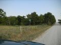
Looks like I'm walking (and not trespassing) from here.
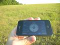
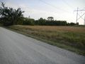
The hashpoint is near!
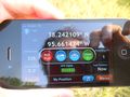
The proof.

My stupid grin.
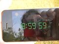
Proof of the leap second.
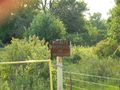
A road sign with no road.
The other side of the road from the road sign.
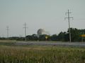
A nuclear reactor.


Achievements
QuantumCop earned the Leap geohash achievement 2012
|
- Land Geohash