Difference between revisions of "2012-06-30 52 13"
From Geohashing
imported>Kattapa (→Photos) |
imported>Jiml m (Fix photo extenions) |
||
| Line 1: | Line 1: | ||
| − | |||
<!-- If you did not specify these parameters in the template, please substitute appropriate values for IMAGE, LAT, LON, and DATE (YYYY-MM-DD format) | <!-- If you did not specify these parameters in the template, please substitute appropriate values for IMAGE, LAT, LON, and DATE (YYYY-MM-DD format) | ||
| Line 31: | Line 30: | ||
== Photos == | == Photos == | ||
<gallery perrow="5"> | <gallery perrow="5"> | ||
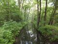
| − | Image:2012_06_30_52_13_1. | + | Image:2012_06_30_52_13_1.jpg|Hash area? |
| − | Image:2012_06_30_52_13_2. | + | Image:2012_06_30_52_13_2.jpg|Roadway? |
| − | Image:2012_06_30_52_13_3. | + | Image:2012_06_30_52_13_3.jpg|Stupid Grin? |
| − | Image:2012_06_30_52_13_4. | + | Image:2012_06_30_52_13_4.jpg|More pathway? |
| − | Image:2012_06_30_52_13_5. | + | Image:2012_06_30_52_13_5.jpg|Hash area? |
</gallery> | </gallery> | ||
| Line 47: | Line 46: | ||
[[Category:New report]] | [[Category:New report]] | ||
| − | |||
| − | |||
| − | |||
| − | |||
| − | |||
[[Category:Expeditions]] | [[Category:Expeditions]] | ||
| − | + | ||
[[Category:Expeditions with photos]] | [[Category:Expeditions with photos]] | ||
| − | |||
| − | |||
| − | |||
<!-- if you reached your coords: | <!-- if you reached your coords: | ||
Revision as of 02:40, 1 July 2012
| Sat 30 Jun 2012 in 52,13: 52.2420946, 13.6615016 geohashing.info google osm bing/os kml crox |
Location
In a Forest south of Königs Wusterhausen.
Participants
Expedition
From Zeesen along some lakes and through some bits of forest to the geohash, then through another forest to Bestensee where I took the train home.
Photos
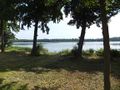
Hash area?
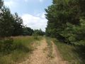
Roadway?
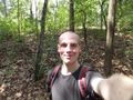
Stupid Grin?
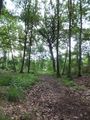
More pathway?
Hash area?


Achievements