Difference between revisions of "2012-07-01 -37 143"
imported>Snaplatitude (→Photos) |
m (More specific location) |
||
| (4 intermediate revisions by 2 users not shown) | |||
| Line 1: | Line 1: | ||
| − | |||
<!-- If you did not specify these parameters in the template, please substitute appropriate values for IMAGE, LAT, LON, and DATE (YYYY-MM-DD format) | <!-- If you did not specify these parameters in the template, please substitute appropriate values for IMAGE, LAT, LON, and DATE (YYYY-MM-DD format) | ||
| Line 30: | Line 29: | ||
We were pressed for time so we rushed out to Dereel, where we had previously attempted to reach a geohash on May 13th. To our dismay we found the hashsite wasn't on the road as we'd expected but it was just off the road in a paddock, but got as close as we could without jumping the fence and breaking trespassing laws.. And without leaving the car because it was bucketing down rain and 6degrees celcius, fffffreeezing. On the way home we stopped by a cool old bridge we found on May 13th. Made it back to town only half an hour late for my next appointment. | We were pressed for time so we rushed out to Dereel, where we had previously attempted to reach a geohash on May 13th. To our dismay we found the hashsite wasn't on the road as we'd expected but it was just off the road in a paddock, but got as close as we could without jumping the fence and breaking trespassing laws.. And without leaving the car because it was bucketing down rain and 6degrees celcius, fffffreeezing. On the way home we stopped by a cool old bridge we found on May 13th. Made it back to town only half an hour late for my next appointment. | ||
| − | == | + | == Achievements == |
| − | + | {{#vardefine:ribbonwidth|800px}} | |
| + | {{No trespassing | ||
| + | |||
| + | | latitude = -37 | ||
| + | | longitude = 143 | ||
| + | | date = 2012-07-01 | ||
| + | | name = Snaplatitude | ||
| + | |||
| + | }} | ||
== Photos == | == Photos == | ||
| Line 42: | Line 49: | ||
Image:2012-07-01_-37_143_20-06-19-950.jpg | the hashpoint is just over the fence here | Image:2012-07-01_-37_143_20-06-19-950.jpg | the hashpoint is just over the fence here | ||
</gallery> | </gallery> | ||
| − | |||
| − | |||
| − | |||
| − | |||
<!-- =============== USEFUL CATEGORIES FOLLOW ================ | <!-- =============== USEFUL CATEGORIES FOLLOW ================ | ||
Delete the next line ONLY if you have chosen the appropriate categories below. If you are unsure, don't worry. People will read your report and help you with the classification. --> | Delete the next line ONLY if you have chosen the appropriate categories below. If you are unsure, don't worry. People will read your report and help you with the classification. --> | ||
| − | |||
| − | |||
| − | |||
| − | |||
| − | |||
| − | |||
| − | |||
[[Category:Expeditions]] | [[Category:Expeditions]] | ||
| − | |||
[[Category:Expeditions with photos]] | [[Category:Expeditions with photos]] | ||
| − | |||
| − | |||
| − | |||
| − | |||
| − | |||
| − | |||
| − | |||
| − | |||
| − | |||
[[Category:Coordinates not reached]] | [[Category:Coordinates not reached]] | ||
| − | + | [[Category:Not reached - No public access]] | |
| − | + | {{location|AU|VIC|GP}} | |
| − | [[Category:Not reached - No public access]] | ||
| − | |||
| − | |||
| − | |||
Latest revision as of 12:18, 1 August 2020
| Sun 1 Jul 2012 in -37,143: -37.8506096, 143.7131653 geohashing.info google osm bing/os kml crox |
Location
-37.85061°, 143.713165° In a private paddock just off a road between Rokewood Junction and Dereel, Victoria Australia.
Participants
- Snaplatitude and 3 other (non-account-holding) people.
Plans
After lunch it was suggested we go geohashing, we checked the co-ordinates for today and lo! Today's coordinate was on a road! We were on our way after a quick toilet break. Had to be back within an hour and a half and a quick check on google maps showed that the trip would take 45minutes either way... we'd better hurry!
Expedition
We were pressed for time so we rushed out to Dereel, where we had previously attempted to reach a geohash on May 13th. To our dismay we found the hashsite wasn't on the road as we'd expected but it was just off the road in a paddock, but got as close as we could without jumping the fence and breaking trespassing laws.. And without leaving the car because it was bucketing down rain and 6degrees celcius, fffffreeezing. On the way home we stopped by a cool old bridge we found on May 13th. Made it back to town only half an hour late for my next appointment.
Achievements
Snaplatitude earned the No trespassing consolation prize
|
Photos
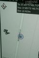
@-37.8506,143.7134 - proof!! (as close as we could get. 23 metres away)
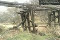
The cool old bridge
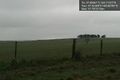
the hashpoint is just over the fence here


