Difference between revisions of "2012-07-07 47 7"
imported>Hijackal (will go.) |
imported>Hijackal (Report. And easy Tale of two hashes.) |
||
| Line 13: | Line 13: | ||
== Plans == | == Plans == | ||
| − | [[User:Hijackal|Hijackal]] thinks this is a nice Saturday hash. Possibly a deja vu, as he lived very | + | [[User:Hijackal|Hijackal]] thinks this is a nice Saturday hash. Possibly a deja vu, as he lived very close last summer. |
He will try to be there at about hash o'clock. | He will try to be there at about hash o'clock. | ||
== Expedition == | == Expedition == | ||
| − | + | Hjackal left home 90 minutes before hash o'clock, biking through the full sun on a nice summer Saturday. The first half of the ride takes him through Freiburg and east along the Dreisam - all nice and flat, speed limited by the amount of other bikers. Now for the interesting bit: leaving the Dreisam, it's up to Oberried and then straight up towards the hash. Hijackal lived here last summer - it's a nice change not to have to navigate at all, he's been 200 m from the hash before... | |
| + | |||
| + | Not by bike, though. The last 500 m of the bike route have an average inclination of 17% - and no shade at all. Someone was expecting a hasher on a white-red bike, apparently: the bench I chain my bike to is decorated with balloons in matching colors. | ||
| + | |||
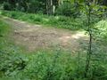
| + | After changing from biking to hiking footwear, Hijackal leaves the road he knows and goes for the final approach through the forest. A convenient path leads up another 50 m of altitude to within 10 m of the hash, which is easily reached, just before 16:00. GPS is lousy, so Hijackal decides 2m are enough. | ||
| + | |||
| + | A life-size hash-marker is scratched into the clearing visible from the hash to kill time until hash o'clock. After enjoying the view into the valley, Hijackal speeds back down towards Freiburg. | ||
| + | |||
| + | On the way back, a short detour is made to Hijackal's lab to start a measurement he had somehow forgotten on Friday. Including this detour, the way back takes exactly as long as the way uphill to the hash. | ||
| + | |||
| + | At home, he finds out that [[User:Murfie|Murfie]]'s attempt to syncro-hash was successful, making this an instant "Tale of two hashes" achievement. Yay! | ||
| − | |||
| − | |||
== Photos == | == Photos == | ||
| − | |||
| − | |||
| − | |||
<gallery perrow="5"> | <gallery perrow="5"> | ||
| + | Image:2012-07-07_47_7_from_plain.JPG | Nontrivial geography looms. | ||
| + | Image:2012-07-07_47_7_bike_balloons.JPG | Enough altitude by bike. And a bike stand predecorated in matching colors! (Deja vu bench, too) | ||
| + | Image:2012-07-07_47_7_shoesshoes.JPG | Take off silly shoes. Put on differently silly shoes. | ||
| + | Image:2012-07-07_47_7_gps.JPG | Bad reception. At least the altitude is correct... | ||
| + | Image:2012-07-07_47_7_grin.JPG | It's a hasher! He's smiling! And sweaty! | ||
| + | Image:2012-07-07_47_7_hash_marker.JPG | Let's make it clear the internet was here. | ||
| + | Image:2012-07-07_47_7_hash_marker_from_hash.JPG | Artwork, as seen from the actual hashpoint | ||
| + | Image:2012-07-07_47_7_view_from_hash.JPG | About 50 m from the hash, enjoy the view... | ||
</gallery> | </gallery> | ||
== Achievements == | == Achievements == | ||
| − | {{ | + | {{land geohash |
| − | + | | latitude = 47 | |
| + | | longitude = 7 | ||
| + | | date = 2012-07-07 | ||
| + | | name = [[User:Hijackal|Hijackal]] | ||
| + | }} | ||
| − | [[ | + | {{Bicycle geohash |
| + | | latitude = 47 | ||
| + | | longitude = 7 | ||
| + | | date = 2012-07-07 | ||
| + | | name = [[User:Hijackal|Hijackal]] | ||
| + | | distance = 48,4 km | ||
| + | }} | ||
| − | [[ | + | {{A Tale of Two Hashes | latitude = 47 | longitude = 7 | date = 2012-07-07 | user2 = [[User:Murfie|Murfie]] | place = The Milky Way | name = [[User:Hijackal|Hijackal]] | image = 2012-07-07_47_7_view_from_hash.JPG }} |
| − | |||
[[Category:Expeditions]] | [[Category:Expeditions]] | ||
| − | + | ||
[[Category:Expeditions with photos]] | [[Category:Expeditions with photos]] | ||
| − | + | ||
| − | |||
| − | |||
| − | |||
| − | |||
[[Category:Coordinates reached]] | [[Category:Coordinates reached]] | ||
| − | |||
| − | |||
| − | |||
| − | |||
| − | |||
| − | |||
| − | |||
| − | |||
| − | |||
| − | |||
| − | |||
| − | |||
| − | |||
| − | |||
Revision as of 15:07, 8 July 2012
| Sat 7 Jul 2012 in 47,7: 47.9317258, 7.9311023 geohashing.info google osm bing/os kml crox |
Location
Between Oberried and the Rappenecker Hütte - in the Black Forest southeast of Freiburg
Participants
Plans
Hijackal thinks this is a nice Saturday hash. Possibly a deja vu, as he lived very close last summer.
He will try to be there at about hash o'clock.
Expedition
Hjackal left home 90 minutes before hash o'clock, biking through the full sun on a nice summer Saturday. The first half of the ride takes him through Freiburg and east along the Dreisam - all nice and flat, speed limited by the amount of other bikers. Now for the interesting bit: leaving the Dreisam, it's up to Oberried and then straight up towards the hash. Hijackal lived here last summer - it's a nice change not to have to navigate at all, he's been 200 m from the hash before...
Not by bike, though. The last 500 m of the bike route have an average inclination of 17% - and no shade at all. Someone was expecting a hasher on a white-red bike, apparently: the bench I chain my bike to is decorated with balloons in matching colors.
After changing from biking to hiking footwear, Hijackal leaves the road he knows and goes for the final approach through the forest. A convenient path leads up another 50 m of altitude to within 10 m of the hash, which is easily reached, just before 16:00. GPS is lousy, so Hijackal decides 2m are enough.
A life-size hash-marker is scratched into the clearing visible from the hash to kill time until hash o'clock. After enjoying the view into the valley, Hijackal speeds back down towards Freiburg.
On the way back, a short detour is made to Hijackal's lab to start a measurement he had somehow forgotten on Friday. Including this detour, the way back takes exactly as long as the way uphill to the hash.
At home, he finds out that Murfie's attempt to syncro-hash was successful, making this an instant "Tale of two hashes" achievement. Yay!
Photos
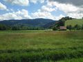
Nontrivial geography looms.
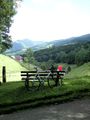
Enough altitude by bike. And a bike stand predecorated in matching colors! (Deja vu bench, too)
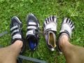
Take off silly shoes. Put on differently silly shoes.
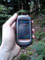
Bad reception. At least the altitude is correct...

It's a hasher! He's smiling! And sweaty!
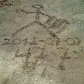
Let's make it clear the internet was here.
Artwork, as seen from the actual hashpoint
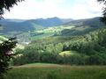
About 50 m from the hash, enjoy the view...


Achievements
Hijackal earned the Land geohash achievement
|
Hijackal earned the Bicycle geohash achievement
|
