Difference between revisions of "2012-07-07 51 4"
imported>Murfie (→Photos) |
imported>FippeBot m (Location) |
||
| (7 intermediate revisions by 3 users not shown) | |||
| Line 1: | Line 1: | ||
| − | |||
<!-- If you did not specify these parameters in the template, please substitute appropriate values for IMAGE, LAT, LON, and DATE (YYYY-MM-DD format) | <!-- If you did not specify these parameters in the template, please substitute appropriate values for IMAGE, LAT, LON, and DATE (YYYY-MM-DD format) | ||
| Line 15: | Line 14: | ||
}} | }} | ||
| − | + | ||
__NOTOC__ | __NOTOC__ | ||
== Location == | == Location == | ||
| − | + | ||
Melkweg (Milky Way), Gemeente Zederik, Hoogewaard. | Melkweg (Milky Way), Gemeente Zederik, Hoogewaard. | ||
== Participants == | == Participants == | ||
| − | + | ||
| − | + | * [[User:Murfie|Murfie]] | |
| − | [[User:Murfie|Murfie]] | ||
== Plans == | == Plans == | ||
| − | + | ||
I plan to arrive somewhere in the afternoon (CET). Upon arrival I'll put up a Tale of Two Hashes challenge for the Milky Way. This is also an invitation to record the quickest met challenge of the Tale of Two Hashes. If you want to tune an arrangement for this, let me know on the discussion page or preferably IRC. | I plan to arrive somewhere in the afternoon (CET). Upon arrival I'll put up a Tale of Two Hashes challenge for the Milky Way. This is also an invitation to record the quickest met challenge of the Tale of Two Hashes. If you want to tune an arrangement for this, let me know on the discussion page or preferably IRC. | ||
== Expedition == | == Expedition == | ||
| − | + | ||
| − | + | ||
| + | The geohash location turned out to be in a grass field on the Melkweg in Langerak. Around 15:50h when I drove up the road to the geohash, I saw two parachutes heading for the field where the geohash was located. First I thought they had just jumped out of a plane, to show for the best Saturday Meetup ever. But it turned out they were just minding their own business with para-sailing or para-gliding, or para-whatevering. I made some pictures, and this immediately gave a good excuse to cross the two fences to reach the geohash, because they were better visible from that point. | ||
| + | |||
| + | I could also see the [http://en.wikipedia.org/wiki/Gerbrandy_Tower Gerbrandy Tower] from that point. An almost 400m high antenna, responsible for broadcasting most of the Dutch TV/Radio channels. I stayed at the hash until a few minutes after 4 o'clock to wait for a like-minded geek, but alas, nobody showed up. | ||
== Tracklog == | == Tracklog == | ||
| Line 38: | Line 39: | ||
== Photos == | == Photos == | ||
| − | + | ||
| − | |||
| − | |||
<gallery perrow="5"> | <gallery perrow="5"> | ||
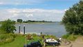
Image:2012-07-07_51_4-melkweg.jpg | Melkweg ("Milky Way") | Image:2012-07-07_51_4-melkweg.jpg | Melkweg ("Milky Way") | ||
| + | Image:2012-07-07_51_4-melkweg2.jpg | The geohash is on other side of the water.. | ||
| + | Image:2012-07-07_51_4-melkweg3.jpg | (other side of the road) Duck Cage | ||
| + | Image:2012-07-07_51_4-melkweg4.jpg | Parasailing people | ||
| + | Image:2012-07-07_51_4-melkweg4b.jpg | A bit better view of a parasailer | ||
| + | Image:2012-07-07_51_4-melkweg5.jpg | My feet at the geohash | ||
| + | Image:2012-07-07_51_4-melkweg6.jpg | The 'Melkweg' as seen from the geohash | ||
| + | Image:2012-07-07_51_4-melkweg7.jpg | The secret how I got over the water. If you look closely, you see the Gerbrandy Tower | ||
| + | Image:2012-07-07_51_4-melkweg8.jpg | People swimming in the 'Lek', a nearby river | ||
</gallery> | </gallery> | ||
== Achievements == | == Achievements == | ||
| + | |||
| + | |||
{{#vardefine:ribbonwidth|800px}} | {{#vardefine:ribbonwidth|800px}} | ||
<!-- Add any achievement ribbons you earned below, or remove this section --> | <!-- Add any achievement ribbons you earned below, or remove this section --> | ||
| + | {{A Tale of Two Hashes challenge | ||
| + | | latitude = 51 | ||
| + | | longitude = 4 | ||
| + | | date = 2012-07-07 | ||
| + | | name = [[User:Murfie|Murfie]] | ||
| + | | place = The Milky Way | ||
| + | | image = 2012-07-07_51_4-melkweg.jpg | ||
| + | }} | ||
| − | + | {{A Tale of Two Hashes | |
| − | |||
| − | |||
| − | + | | latitude = 47 | |
| − | + | | longitude = 7 | |
| − | [[ | + | | date = 2012-07-07 |
| − | -- | + | | user2 = [[User:Murfie|Murfie]] |
| + | | place = The Milky Way | ||
| + | | name = [[User:Hijackal|Hijackal]] | ||
| + | | image = 2012-07-07_47_7_view_from_hash.JPG | ||
| + | |||
| + | }} | ||
| − | |||
[[Category:Expeditions]] | [[Category:Expeditions]] | ||
| − | + | ||
[[Category:Expeditions with photos]] | [[Category:Expeditions with photos]] | ||
| − | |||
| − | |||
| − | |||
| − | |||
| − | |||
[[Category:Coordinates reached]] | [[Category:Coordinates reached]] | ||
| − | + | {{location|NL|ZH}} | |
| − | |||
| − | |||
| − | |||
| − | |||
| − | |||
| − | |||
| − | |||
| − | |||
| − | |||
| − | |||
| − | |||
| − | |||
| − | |||
Latest revision as of 04:57, 13 August 2019
| Sat 7 Jul 2012 in 51,4: 51.9317258, 4.9311023 geohashing.info google osm bing/os kml crox |
Location
Melkweg (Milky Way), Gemeente Zederik, Hoogewaard.
Participants
Plans
I plan to arrive somewhere in the afternoon (CET). Upon arrival I'll put up a Tale of Two Hashes challenge for the Milky Way. This is also an invitation to record the quickest met challenge of the Tale of Two Hashes. If you want to tune an arrangement for this, let me know on the discussion page or preferably IRC.
Expedition
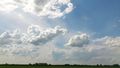
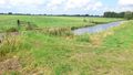
The geohash location turned out to be in a grass field on the Melkweg in Langerak. Around 15:50h when I drove up the road to the geohash, I saw two parachutes heading for the field where the geohash was located. First I thought they had just jumped out of a plane, to show for the best Saturday Meetup ever. But it turned out they were just minding their own business with para-sailing or para-gliding, or para-whatevering. I made some pictures, and this immediately gave a good excuse to cross the two fences to reach the geohash, because they were better visible from that point.
I could also see the Gerbrandy Tower from that point. An almost 400m high antenna, responsible for broadcasting most of the Dutch TV/Radio channels. I stayed at the hash until a few minutes after 4 o'clock to wait for a like-minded geek, but alas, nobody showed up.
Tracklog
Photos
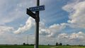
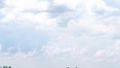
Melkweg ("Milky Way")
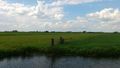
The geohash is on other side of the water..
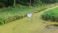
(other side of the road) Duck Cage
Parasailing people
A bit better view of a parasailer
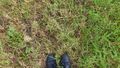
My feet at the geohash
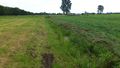
The 'Melkweg' as seen from the geohash
The secret how I got over the water. If you look closely, you see the Gerbrandy Tower
People swimming in the 'Lek', a nearby river


Achievements

