Difference between revisions of "2012-07-12 39 -106"
imported>Topbun (→Photos) |
imported>FippeBot m (Location) |
||
| (16 intermediate revisions by 2 users not shown) | |||
| Line 1: | Line 1: | ||
| − | |||
<!-- If you did not specify these parameters in the template, please substitute appropriate values for IMAGE, LAT, LON, and DATE (YYYY-MM-DD format) | <!-- If you did not specify these parameters in the template, please substitute appropriate values for IMAGE, LAT, LON, and DATE (YYYY-MM-DD format) | ||
| Line 21: | Line 20: | ||
== Participants == | == Participants == | ||
| − | [[User:Topbun]] | + | [[User:Topbun|Topbun]] |
== Plans == | == Plans == | ||
<!-- what were the original plans --> | <!-- what were the original plans --> | ||
The plan was to ride my trusty mare, Janis, to the area and find a place to park. | The plan was to ride my trusty mare, Janis, to the area and find a place to park. | ||
| + | |||
| + | [[File:Topbun_Janis.JPG|center|230px|thumb|My trusty mare, Janis.]] | ||
== Expedition == | == Expedition == | ||
<!-- how it all turned out. your narrative goes here. --> | <!-- how it all turned out. your narrative goes here. --> | ||
| − | The motorcycle ride up CO-9 was familiar, but still scenic. I realized I had forgotten how good the Dillon Reservoir looks in the daytime. I turned around on I-70 after I reached the "Officer's Gulch" exit and parked at the nearest location which was in proximity to a relatively popular bicycle path. I then followed the path roughly Northeast for about 2 miles. I then looked up at the location of the hash and proceeded to drop off the path (which was located about 15 feet above) into a densely wooded ravine. A deep sense of loneliness suddenly struck me as I began to sort my way through the maze of fallen trees and their living counterparts. Then the woods broke and in front of me was a daunting cliff face with a few old mining tailings running down its steep slope. I decided that I couldn't come this far without taking a shot at it. The first part of the climb up the mine tailings was not terrible, but was difficult to get a solid foothold in the groups of smaller rocks. Shortly after getting to the top of the tailings, I decided to mark my GPS and leave my motorcycle jacket and helmet behind for the remainder of the climb to help my balance. I climbed a steep, rocky face until I got within 184 +/- 49 | + | The motorcycle ride up CO-9 was familiar, but still scenic. I realized I had forgotten how good the Dillon Reservoir looks in the daytime. I turned around on I-70 after I reached the "Officer's Gulch" exit and parked at the nearest location which was in proximity to a relatively popular bicycle path. I then followed the path roughly Northeast for about 2 miles. I then looked up at the location of the hash and proceeded to drop off the path (which was located about 15 feet above) into a densely wooded ravine. A deep sense of loneliness suddenly struck me as I began to sort my way through the maze of fallen trees and their living counterparts. Then the woods broke and in front of me was a daunting cliff face with a few old mining tailings running down its steep slope. I decided that I couldn't come this far without taking a shot at it. The first part of the climb up the mine tailings was not terrible, but was difficult to get a solid foothold in the groups of smaller rocks. Shortly after getting to the top of the tailings, I decided to mark my GPS and leave my motorcycle jacket and helmet behind for the remainder of the climb to help my balance. I climbed a steep, rocky face until I got within 184 +/- 49 feet of the hash. It appeared that the hash point was ultimately unreachable, as I believed it to be located on a very steep out-jutting cliff. |
[[File:2012-07-12 39 -106.JPG|230px|thumb|Stupid grin.]] | [[File:2012-07-12 39 -106.JPG|230px|thumb|Stupid grin.]] | ||
| Line 36: | Line 37: | ||
[[File:2012-07-12_39_-106_distance.JPG|left|230px|thumb|184 ft to hash.]] | [[File:2012-07-12_39_-106_distance.JPG|left|230px|thumb|184 ft to hash.]] | ||
| − | [[File:2012-07-12_39_-106_look1.JPG|center|230px|thumb|Overlook of I-70 from the hash point. | + | [[File:2012-07-12_39_-106_look1.JPG|center|230px|thumb|Overlook of I-70 from (near) the hash point. |
]] | ]] | ||
| − | |||
| Line 46: | Line 46: | ||
--> | --> | ||
<gallery perrow="5"> | <gallery perrow="5"> | ||
| + | Image:2012-07-12_39_-106_woods.JPG | Wooded area before the mine tailings. | ||
| + | Image:2012-07-12_39_-106_cliffs.JPG | Cliffs of despair! | ||
| + | Image:2012-07-12_39_-106_details.JPG | GPS details/proof of failure. | ||
| + | Image:2012-07-12_39_-106_I-70_Overlook.JPG | Westbound (Southwest) overlook of I-70 near CO-9. (Grey skies moving in) | ||
</gallery> | </gallery> | ||
| Line 53: | Line 57: | ||
| − | |||
| − | |||
| − | |||
| − | + | {{Cliffs of Despair | |
| − | + | ||
| − | + | | latitude = 39 | |
| − | + | | longitude = -106 | |
| + | | date = 2012-07-12 | ||
| + | | name = Topbun | ||
| + | | terrain = a cliff | ||
| + | |||
| + | }} | ||
| + | |||
| − | |||
[[Category:Expeditions]] | [[Category:Expeditions]] | ||
| − | |||
[[Category:Expeditions with photos]] | [[Category:Expeditions with photos]] | ||
| − | |||
| − | |||
| − | |||
| − | |||
| − | |||
| − | |||
| − | |||
| − | |||
| − | |||
[[Category:Coordinates not reached]] | [[Category:Coordinates not reached]] | ||
| − | |||
| − | |||
[[Category:Not reached - Mother Nature]] | [[Category:Not reached - Mother Nature]] | ||
| − | + | {{location|US|CO|SU}} | |
| − | |||
| − | |||
| − | |||
| − | |||
| − | |||
| − | |||
| − | |||
| − | |||
| − | |||
| − | |||
Latest revision as of 04:58, 6 August 2019
| Thu 12 Jul 2012 in 39,-106: 39.5602736, -106.1258612 geohashing.info google osm bing/os kml crox |
Location
Today's hash is located on a mountainous outcropping near I-70 and CO-9 by Frisco, CO.
Participants
Plans
The plan was to ride my trusty mare, Janis, to the area and find a place to park.

Expedition
The motorcycle ride up CO-9 was familiar, but still scenic. I realized I had forgotten how good the Dillon Reservoir looks in the daytime. I turned around on I-70 after I reached the "Officer's Gulch" exit and parked at the nearest location which was in proximity to a relatively popular bicycle path. I then followed the path roughly Northeast for about 2 miles. I then looked up at the location of the hash and proceeded to drop off the path (which was located about 15 feet above) into a densely wooded ravine. A deep sense of loneliness suddenly struck me as I began to sort my way through the maze of fallen trees and their living counterparts. Then the woods broke and in front of me was a daunting cliff face with a few old mining tailings running down its steep slope. I decided that I couldn't come this far without taking a shot at it. The first part of the climb up the mine tailings was not terrible, but was difficult to get a solid foothold in the groups of smaller rocks. Shortly after getting to the top of the tailings, I decided to mark my GPS and leave my motorcycle jacket and helmet behind for the remainder of the climb to help my balance. I climbed a steep, rocky face until I got within 184 +/- 49 feet of the hash. It appeared that the hash point was ultimately unreachable, as I believed it to be located on a very steep out-jutting cliff.

With the skies greying, and no climbing gear to reach the final point, I took my pictures, had a somewhat celebratory yalp, and headed back down to my gear. It began to rain lightly on and off as I reached the path again, but I welcomed it as I was sweating like a madman after the climb. I walked the 2 miles back to my bike and realized along the way that not all was lost, for this was a classic case of Cliffs of Despair!


Photos
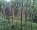
Wooded area before the mine tailings.

Cliffs of despair!

GPS details/proof of failure.
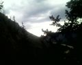
Westbound (Southwest) overlook of I-70 near CO-9. (Grey skies moving in)


Achievements
Topbun earned the Cliffs of Despair consolation prize
|