Difference between revisions of "2012-07-15 52 5"
imported>Eupeodes (→Eupeodes) |
imported>Eupeodes (→Achievements) |
||
| Line 65: | Line 65: | ||
{{#vardefine:ribbonwidth|800px}} | {{#vardefine:ribbonwidth|800px}} | ||
<!-- Add any achievement ribbons you earned below, or remove this section --> | <!-- Add any achievement ribbons you earned below, or remove this section --> | ||
| + | {{Combo | ||
| + | | latitude = 52 | ||
| + | | longitude = 5 | ||
| + | | date = 2012-07-15 | ||
| + | | comboname = Earliest consecutive bicycle tron land geohash achievement | ||
| + | | action = biking to the hash, reaching it before Shevek and not crossing his own trail | ||
| + | | name = [[User:Eupeodes|Eupeodes]] | ||
| + | | image = | ||
| + | | icon1 = Earliest.jpg | ||
| + | | icon2 = consecutivegeohash.jpg | ||
| + | | icon3 = Bikegeohash.png | ||
| + | | icon4 = Lightcycle.png | ||
| + | | icon5 = Landgeohash.png | ||
| + | | cat1 = Earliest_geohasher | ||
| + | | cat2 = Consecutive_hash | ||
| + | | cat3 = Bicycle_hash | ||
| + | | cat4 = Tron | ||
| + | | cat5 = Land_geohash_achievement | ||
| + | }} | ||
| + | {{Earliest geohasher | ||
| + | | latitude = 52 | ||
| + | | longitude = 5 | ||
| + | | date = 2012-07-15 | ||
| + | | name = [[User:Eupeodes|Eupeodes]] | ||
| + | }} | ||
| + | {{consecutive geohash | ||
| + | | latitude = 52 | ||
| + | | longitude = 5 | ||
| + | | date = 2012-07-15 | ||
| + | | name = [[User:Eupeodes|Eupeodes]] | ||
| + | | count = 2 | ||
| + | | date = 2012-07-14 | ||
| + | }} | ||
| + | {{Bicycle geohash | ||
| + | | latitude = 52 | ||
| + | | longitude = 5 | ||
| + | | date = 2012-07-15 | ||
| + | | name = [[User:Eupeodes|Eupeodes]] | ||
| + | | distance = 100 km (40 there, 60 back) | ||
| + | }} | ||
| + | {{Tron | ||
| + | | latitude = 52 | ||
| + | | longitude = 5 | ||
| + | | date = 2012-07-15 | ||
| + | | name = [[User:Eupeodes|Eupeodes]] | ||
| + | | tracklog = https://maps.google.nl/maps?q=http:%2F%2Fgeohashing.eupeodes.nl%2Ftracks%2F20120715.kml&hl=nl&ll=52.16795,5.976855&spn=0.063489,0.110378&sll=51.977816,5.744769&sspn=0.255039,0.441513&t=w&z=13 | ||
| + | | possessive = his | ||
| + | }} | ||
| + | {{land geohash | ||
| + | | latitude = 52 | ||
| + | | longitude = 5 | ||
| + | | date = 2012-07-15 | ||
| + | | name = [[User:Eupeodes|Eupeodes]] | ||
| + | }} | ||
| − | |||
| − | |||
| − | |||
| − | |||
| − | |||
| − | |||
| − | |||
| − | |||
| − | |||
| − | |||
[[Category:Expeditions]] | [[Category:Expeditions]] | ||
| − | |||
[[Category:Expeditions with photos]] | [[Category:Expeditions with photos]] | ||
| − | |||
| − | |||
| − | |||
| − | |||
| − | |||
[[Category:Coordinates reached]] | [[Category:Coordinates reached]] | ||
| − | + | [[Category:Eupeodes]] | |
| − | |||
| − | |||
| − | |||
| − | |||
| − | |||
| − | |||
| − | |||
| − | |||
| − | |||
| − | |||
| − | |||
| − | |||
| − | |||
| − | |||
| − | [[Category: | ||
| − | |||
| − | |||
Revision as of 22:38, 15 July 2012
| Sun 15 Jul 2012 in 52,5: 52.1840800, 5.9890418 geohashing.info google osm bing/os kml crox |
Location
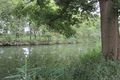
In Apeldoorn on the bank of the Apeldoorn Kanaal
Participants
Plans
Shevek planned to go hitchhiking and be there at 3pm, Eupeodes decided to go by bike and arrive at the same moment. It worked out differently.
Expedition
Eupeodes
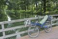
Intended to leave at around 1pm so I would be there at 3pm and be back home before dinner. In the end I left at around 3:45 by recumbent bike. The ride started nice, bit up and down. Of course my speed dropped around Hoenderloo, it always does. After this I had some longe stretches down, speeds exceeded 40 km/h, it was chilly. Arrived at the hashpoint at 5:36pm. Took some pictures and set of to get back home. Since I was aiming for tron and I don't like driving the same way back anyways I took a different route. After some time it started to rain so I took shelter under a tree. Waited until the worst part passed and just at that moment the tree started to leak so I continued my way. When I was in Arnhem it was already around 8pm and I hadn't had diner yet, so got some pasta at Julia's at the central station. Now I could continue my way home and I arrived home with a bit over 100 km driven (40 to the hash, 60 the way back).
It turned out to be some advantage that Eupeodes knew the way quite well. His parents live only about one kilometer from the hash, so he knew the way to the hash. Although Eupeodes cycled/walked almost every part of the Kanaal, the hash appeared to be on one of those rare sections where he had never been yet.
Shevek
Tracklog
Photos
Eupeodes
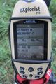

Picture taken some distance from the hash

Noticed the pictures from the hash with bike were rubish

The rain

In Arnhem
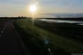
Sun going down
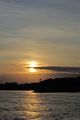
Sun going down


Achievements
Eupeodes earned the Earliest consecutive bicycle tron land geohash achievement Achievement
|
Eupeodes earned the Earliest geohasher achievement
|
Eupeodes earned the Consecutive geohash achievement
|
Eupeodes earned the Bicycle geohash achievement
|
Eupeodes earned the Tron achievement
|
Eupeodes earned the Land geohash achievement
|
- Pages using duplicate arguments in template calls
- Meetup on 2012-07-15
- Meetup in 52 5
- Combo achievement
- Earliest geohasher
- Consecutive hash
- Bicycle hash
- Tron
- Land geohash achievement
- Earliest geohash achievement
- Consecutive geohash achievement
- Bicycle geohash achievement
- Tron achievement
- Expeditions
- Expeditions with photos
- Coordinates reached
- Eupeodes