Difference between revisions of "2012-07-16 33 -117"
imported>LucasBrown ([live picture] The hashpoint is just beyond the bush, within an arm's length of the fence [http://www.openstreetmap.org/?lat=33.07654407&lon=-117.20846856&zoom=16&layers=B000FTF @33.0765,-117.2085]) |
imported>FippeBot m (Location) |
||
| (9 intermediate revisions by 2 users not shown) | |||
| Line 1: | Line 1: | ||
| − | |||
| − | |||
| − | |||
| − | |||
| − | |||
| − | |||
| − | |||
| − | |||
| − | |||
| − | |||
{{meetup graticule | {{meetup graticule | ||
| lat=33 | | lat=33 | ||
| Line 15: | Line 5: | ||
}} | }} | ||
| − | |||
__NOTOC__ | __NOTOC__ | ||
== Location == | == Location == | ||
| − | + | Just barely in somebody's fenced-in backyard off Cantle Lane in Rancho Santa Fe. The hashpoint can be reached by stretching an arm over the fence, but foot access to the hashpoint will require the property owner's permission. | |
== Participants == | == Participants == | ||
| − | + | * [[User:LucasBrown|LucasBrown]] reached the hashpoint at about 13:30. | |
| − | + | ||
| + | At least one other hasher seems to have attempted this hash, but the hasher's identity remains unknown. | ||
== Plans == | == Plans == | ||
| Line 28: | Line 18: | ||
== Expedition == | == Expedition == | ||
| − | + | [[User:LucasBrown|LucasBrown]]'s expedition: | |
| + | |||
| + | The hashpoint is actually in a gated community. To access the community, the hasher waited in the car for someone with the access codes to enter and then tailgated the other vehicle in. The hasher subsequently arrived at the head of a recreational trail just under 100m from the hashpoint; the hasher thereupon walked down the trail to within two meters of the hashpoint only to find that it was on the opposite side of a fence. Holding his GPS over the fence, however, the hasher was able to get the device within its error interval (about 3m) of the hashpoint. | ||
| − | |||
| − | |||
== Photos == | == Photos == | ||
| − | + | ||
| − | |||
| − | |||
<gallery perrow="5"> | <gallery perrow="5"> | ||
| − | |||
Image:2012-07-16_33_-117_09-36-34-404.jpg | First time making it to the geohash | Image:2012-07-16_33_-117_09-36-34-404.jpg | First time making it to the geohash | ||
| + | </gallery> | ||
| + | Photos from LucasBrown's expedition: | ||
| + | <gallery perrow="5"> | ||
Image:2012-07-16_33_-117_13-08-45-661.jpg | Geohash Droid map at the hashpoint [http://www.openstreetmap.org/?lat=33.07655516&lon=-117.20846807&zoom=16&layers=B000FTF @33.0766,-117.2085] | Image:2012-07-16_33_-117_13-08-45-661.jpg | Geohash Droid map at the hashpoint [http://www.openstreetmap.org/?lat=33.07655516&lon=-117.20846807&zoom=16&layers=B000FTF @33.0766,-117.2085] | ||
| − | |||
Image:2012-07-16_33_-117_13-09-32-026.jpg | Geohash Droid details page at the hashpoint [http://www.openstreetmap.org/?lat=33.07655569&lon=-117.20846869&zoom=16&layers=B000FTF @33.0766,-117.2085] | Image:2012-07-16_33_-117_13-09-32-026.jpg | Geohash Droid details page at the hashpoint [http://www.openstreetmap.org/?lat=33.07655569&lon=-117.20846869&zoom=16&layers=B000FTF @33.0766,-117.2085] | ||
| − | |||
Image:2012-07-16_33_-117_13-11-55-932.jpg | The hashpoint is just beyond the bush, within an arm's length of the fence [http://www.openstreetmap.org/?lat=33.07654407&lon=-117.20846856&zoom=16&layers=B000FTF @33.0765,-117.2085] | Image:2012-07-16_33_-117_13-11-55-932.jpg | The hashpoint is just beyond the bush, within an arm's length of the fence [http://www.openstreetmap.org/?lat=33.07654407&lon=-117.20846856&zoom=16&layers=B000FTF @33.0765,-117.2085] | ||
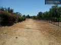
| + | Image:2012-07-16_33_-117_13-12-45-239.jpg | The trail from the road to the hashpoint [http://www.openstreetmap.org/?lat=33.07650810&lon=-117.20854798&zoom=16&layers=B000FTF @33.0765,-117.2085] | ||
| + | Image:2012-07-16_33_-117_13-13-25-538.jpg | The trail to the hashpoint, as seen from the hashpoint [http://www.openstreetmap.org/?lat=33.07624450&lon=-117.20879017&zoom=16&layers=B000FTF @33.0762,-117.2088] | ||
| + | Image:2012-07-16_33_-117_13-13-56-556.jpg | Trail sign [http://www.openstreetmap.org/?lat=33.07608239&lon=-117.20895054&zoom=16&layers=B000FTF @33.0761,-117.2090] | ||
| + | Image:2012-07-16_33_-117_13-14-42-567.jpg | Trail marker [http://www.openstreetmap.org/?lat=33.07590125&lon=-117.20884672&zoom=16&layers=B000FTF @33.0759,-117.2088] | ||
</gallery> | </gallery> | ||
== Achievements == | == Achievements == | ||
{{#vardefine:ribbonwidth|800px}} | {{#vardefine:ribbonwidth|800px}} | ||
| − | |||
| + | * Land geohash | ||
| − | |||
| − | |||
| − | |||
| − | |||
| − | |||
| − | |||
| − | |||
| − | |||
| − | |||
| − | |||
[[Category:Expeditions]] | [[Category:Expeditions]] | ||
| − | |||
[[Category:Expeditions with photos]] | [[Category:Expeditions with photos]] | ||
| − | |||
| − | |||
| − | |||
| − | |||
| − | |||
[[Category:Coordinates reached]] | [[Category:Coordinates reached]] | ||
| − | + | {{location|US|CA|SD}} | |
| − | |||
| − | |||
| − | |||
| − | |||
| − | |||
| − | |||
| − | |||
| − | |||
| − | |||
| − | |||
| − | |||
| − | |||
| − | |||
| − | |||
| − | |||
| − | |||
| − | |||
Latest revision as of 05:04, 13 August 2019
| Mon 16 Jul 2012 in 33,-117: 33.0765388, -117.2084135 geohashing.info google osm bing/os kml crox |
Location
Just barely in somebody's fenced-in backyard off Cantle Lane in Rancho Santa Fe. The hashpoint can be reached by stretching an arm over the fence, but foot access to the hashpoint will require the property owner's permission.
Participants
- LucasBrown reached the hashpoint at about 13:30.
At least one other hasher seems to have attempted this hash, but the hasher's identity remains unknown.
Plans
Expedition
LucasBrown's expedition:
The hashpoint is actually in a gated community. To access the community, the hasher waited in the car for someone with the access codes to enter and then tailgated the other vehicle in. The hasher subsequently arrived at the head of a recreational trail just under 100m from the hashpoint; the hasher thereupon walked down the trail to within two meters of the hashpoint only to find that it was on the opposite side of a fence. Holding his GPS over the fence, however, the hasher was able to get the device within its error interval (about 3m) of the hashpoint.
Photos

First time making it to the geohash
Photos from LucasBrown's expedition:
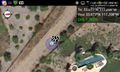
Geohash Droid map at the hashpoint @33.0766,-117.2085
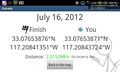
Geohash Droid details page at the hashpoint @33.0766,-117.2085
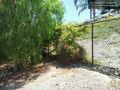
The hashpoint is just beyond the bush, within an arm's length of the fence @33.0765,-117.2085

The trail from the road to the hashpoint @33.0765,-117.2085
The trail to the hashpoint, as seen from the hashpoint @33.0762,-117.2088
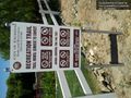
Trail sign @33.0761,-117.2090
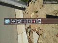
Trail marker @33.0759,-117.2088


Achievements
- Land geohash