Difference between revisions of "2012-07-17 43 -71"
From Geohashing
imported>N-obs (→Participants) |
imported>NWoodruff |
||
| Line 1: | Line 1: | ||
| − | |||
<!-- If you did not specify these parameters in the template, please substitute appropriate values for IMAGE, LAT, LON, and DATE (YYYY-MM-DD format) | <!-- If you did not specify these parameters in the template, please substitute appropriate values for IMAGE, LAT, LON, and DATE (YYYY-MM-DD format) | ||
| Line 51: | Line 50: | ||
<!-- =============== USEFUL CATEGORIES FOLLOW ================ | <!-- =============== USEFUL CATEGORIES FOLLOW ================ | ||
Delete the next line ONLY if you have chosen the appropriate categories below. If you are unsure, don't worry. People will read your report and help you with the classification. --> | Delete the next line ONLY if you have chosen the appropriate categories below. If you are unsure, don't worry. People will read your report and help you with the classification. --> | ||
| − | [[Category: | + | [[Category:Expeditions]] |
| + | [[Category:Expeditions with photos]] | ||
| + | [[Category:Coordinates reached]] | ||
<!-- Potential categories. Please include all the ones appropriate to your expedition --> | <!-- Potential categories. Please include all the ones appropriate to your expedition --> | ||
Revision as of 22:52, 23 August 2012
| Tue 17 Jul 2012 in 43,-71: 43.0333265, -71.4837276 geohashing.info google osm bing/os kml crox |
Location
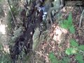
Just west of a small stream, which in turn was only about 5 meters from the road.
Participants
Plans
Expedition
Hard to really call it an expedition. I parked across the street, and wandered into a gulley and after a minute or so, there I was. It looked like someone else had been there before me...
Tracklog
Photos
Super easy - right by the road. @43.0066,-71.4825

Achievements