Difference between revisions of "2012-07-19 50 8"
From Geohashing
imported>Yakamoz (→Photos) |
imported>FippeBot m (Location) |
||
| (14 intermediate revisions by 3 users not shown) | |||
| Line 1: | Line 1: | ||
{{meetup graticule | {{meetup graticule | ||
| lat=50 | | lat=50 | ||
| − | | lon= | + | | lon=8 |
| date=2012-07-19 | | date=2012-07-19 | ||
}} | }} | ||
== Location == | == Location == | ||
| + | |||
| + | |||
On a greenfield across from the university canteen, in Gießen, Hesse. | On a greenfield across from the university canteen, in Gießen, Hesse. | ||
| Line 17: | Line 19: | ||
== Plans == | == Plans == | ||
| − | Go there at request of Rincewind | + | |
| + | |||
| + | Go there at request of Rincewind and avoiding a after-lunch nap. | ||
== Expedition == | == Expedition == | ||
| − | |||
| + | I walked to the hash point, which was easy to find because it was right next to the canteen | ||
| + | of Justus Liebig University where I go almost every day for 4 years. | ||
| + | |||
| + | I didn't have a GPS, so I relied on Google's aerial photo. When I got there, I wasn't sure exactly where the point was, so I walked all around the greenfield to make sure I visited the correct point. | ||
== Photos == | == Photos == | ||
| Line 30: | Line 37: | ||
<gallery perrow="5"> | <gallery perrow="5"> | ||
image:greenfield.jpg|location of the hash point | image:greenfield.jpg|location of the hash point | ||
| − | image:windy.jpg| | + | image:windy.jpg|wind in my hair |
| Line 41: | Line 48: | ||
| latitude = 50 | | latitude = 50 | ||
| − | | longitude = | + | | longitude = 8 |
| date = 2012-07-19 | | date = 2012-07-19 | ||
| name = Yakamoz | | name = Yakamoz | ||
| Line 52: | Line 59: | ||
| latitude = 50 | | latitude = 50 | ||
| − | | longitude = | + | | longitude = 8 |
| date = 2012-07-19 | | date = 2012-07-19 | ||
| name = Yakamoz | | name = Yakamoz | ||
| Line 63: | Line 70: | ||
[[Category:Expeditions]] | [[Category:Expeditions]] | ||
[[Category:Expeditions with photos]] | [[Category:Expeditions with photos]] | ||
| − | [[Category:Coordinates | + | [[Category:Coordinates reached]] |
| + | {{location|DE|HE|GI}} | ||
Latest revision as of 05:07, 13 August 2019
| Thu 19 Jul 2012 in 50,8: 50.5753560, 8.6911301 geohashing.info google osm bing/os kml crox |
Location
On a greenfield across from the university canteen, in Gießen, Hesse.
Participants
Plans
Go there at request of Rincewind and avoiding a after-lunch nap.
Expedition
I walked to the hash point, which was easy to find because it was right next to the canteen of Justus Liebig University where I go almost every day for 4 years.
I didn't have a GPS, so I relied on Google's aerial photo. When I got there, I wasn't sure exactly where the point was, so I walked all around the greenfield to make sure I visited the correct point.
Photos
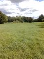
location of the hash point

wind in my hair


Achievements
Yakamoz earned the Land geohash achievement
|
Yakamoz earned the No Batteries Geohash Achievement
|