Difference between revisions of "2012-07-20 49 8"
imported>Mampfred (Created page with "{{subst:Expedition |lat = 49 |lon = 8 |date = 2012-07-20 }}") |
imported>FippeBot m (Location) |
||
| (6 intermediate revisions by one other user not shown) | |||
| Line 1: | Line 1: | ||
| − | |||
| − | |||
| − | |||
| − | |||
| − | |||
| − | |||
| − | |||
| − | |||
| − | |||
| − | |||
{{meetup graticule | {{meetup graticule | ||
| lat=49 | | lat=49 | ||
| Line 15: | Line 5: | ||
}} | }} | ||
| − | |||
__NOTOC__ | __NOTOC__ | ||
== Location == | == Location == | ||
| Line 21: | Line 10: | ||
== Participants == | == Participants == | ||
| − | + | * [[User:QuarterCacher|QuarterCacher]] | |
| − | + | * [[User:Mampfred|Mampfred]] | |
== Plans == | == Plans == | ||
| − | + | Go there late after work. Very dark woods are our speciality :D | |
== Expedition == | == Expedition == | ||
| − | + | We started off at 10:30pm. Although Mampfred is usually quite good in planning hash expeditions now, this one was a total failure. | |
| + | |||
| + | We didn't quite check where we were going. So our car navigation took us to a highway exit that's closed for maintenance and subsequently tried to lead us along a 25 minute detour to the hash. At some point we ignored it though and used google maps so we got there 5 minutes later. | ||
| + | |||
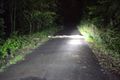
| + | We then misinterpreted a sign saying no access in x-hundred meters and parked right there instead of driving on so the walk was much longer than expected. Half we to the hash we also encountered some wild pigs crossing the street and lingering there (blurry snapshot attached) and had to wait around a while to not disturb them (and getting attacked by the mother). | ||
| + | |||
| + | Thas is all usually not a problem, but it eventually cost us our midnight achievement for the next hash, so we weren't quite amused ;) | ||
| + | |||
| + | To top it all off, Mampfred took spare batteries for the GPS but lost one of them in the trunk of the car. Of course, the GPS ran out of juice on that very night so Mampfred ended up being completely dependant on QuarterCacher and his GPS ... which is obviously hard to take for a proper, self-sufficient hasher ;) | ||
| + | |||
| + | Anyway, we got there and found the hash in the middle of some dense undergrowth. Coordinates reached and we headed back to the car and on to [[2012-07-21 50 8]]. | ||
== Tracklog == | == Tracklog == | ||
| − | + | See [http://www.everytrail.com/view_trip.php?trip_id=1680467 here] (combined for the two hashes). | |
== Photos == | == Photos == | ||
| − | |||
| − | |||
| − | |||
<gallery perrow="5"> | <gallery perrow="5"> | ||
| + | Image:2012-07-20_49_8_pig_procession.jpg | Blury pig procession on the way to the hash. | ||
| + | Image:2012-07-20_49_8_undergrowth.jpg | Thick undergrowth. | ||
| + | Image:2012-07-20_49_8_coords_reached_2.jpg | Coordinates reached | ||
| + | Image:2012-07-20_49_8_undergrowth_grin.jpg | Stupid grin. | ||
</gallery> | </gallery> | ||
== Achievements == | == Achievements == | ||
{{#vardefine:ribbonwidth|800px}} | {{#vardefine:ribbonwidth|800px}} | ||
| − | + | * Land | |
| − | |||
| − | |||
| − | |||
| − | |||
| − | |||
| − | |||
| − | |||
| − | |||
| − | |||
| − | |||
| − | |||
[[Category:Expeditions]] | [[Category:Expeditions]] | ||
| − | |||
[[Category:Expeditions with photos]] | [[Category:Expeditions with photos]] | ||
| − | |||
| − | |||
| − | |||
| − | |||
| − | |||
[[Category:Coordinates reached]] | [[Category:Coordinates reached]] | ||
| − | + | {{location|DE|HE|GG}} | |
| − | |||
| − | |||
| − | |||
| − | |||
| − | |||
| − | |||
| − | |||
| − | |||
| − | |||
| − | |||
| − | |||
| − | |||
| − | |||
| − | |||
| − | |||
| − | |||
| − | |||
Latest revision as of 05:07, 13 August 2019
| Fri 20 Jul 2012 in 49,8: 49.9965545, 8.4638993 geohashing.info google osm bing/os kml crox |
Location
Participants
Plans
Go there late after work. Very dark woods are our speciality :D
Expedition
We started off at 10:30pm. Although Mampfred is usually quite good in planning hash expeditions now, this one was a total failure.
We didn't quite check where we were going. So our car navigation took us to a highway exit that's closed for maintenance and subsequently tried to lead us along a 25 minute detour to the hash. At some point we ignored it though and used google maps so we got there 5 minutes later.
We then misinterpreted a sign saying no access in x-hundred meters and parked right there instead of driving on so the walk was much longer than expected. Half we to the hash we also encountered some wild pigs crossing the street and lingering there (blurry snapshot attached) and had to wait around a while to not disturb them (and getting attacked by the mother).
Thas is all usually not a problem, but it eventually cost us our midnight achievement for the next hash, so we weren't quite amused ;)
To top it all off, Mampfred took spare batteries for the GPS but lost one of them in the trunk of the car. Of course, the GPS ran out of juice on that very night so Mampfred ended up being completely dependant on QuarterCacher and his GPS ... which is obviously hard to take for a proper, self-sufficient hasher ;)
Anyway, we got there and found the hash in the middle of some dense undergrowth. Coordinates reached and we headed back to the car and on to 2012-07-21 50 8.
Tracklog
See here (combined for the two hashes).
Photos
Blury pig procession on the way to the hash.

Thick undergrowth.
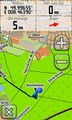
Coordinates reached

Stupid grin.


Achievements
- Land