Difference between revisions of "2012-07-20 55 13"
imported>Llavids |
imported>FippeBot m (Location) |
||
| (3 intermediate revisions by one other user not shown) | |||
| Line 22: | Line 22: | ||
Image:20120720-55-13-01-The-grin.JPG|The grin | Image:20120720-55-13-01-The-grin.JPG|The grin | ||
Image:20120720-55-13-02-Proof.JPG|Proof | Image:20120720-55-13-02-Proof.JPG|Proof | ||
| − | Image:20120720-55-13-09-Proof. | + | Image:20120720-55-13-09-Proof.png|Proof |
Image:20120720-55-13-03-Road-to-hashe.JPG|Road to geohash | Image:20120720-55-13-03-Road-to-hashe.JPG|Road to geohash | ||
Image:20120720-55-13-04-North.JPG|North | Image:20120720-55-13-04-North.JPG|North | ||
| Line 34: | Line 34: | ||
{{Land geohash | latitude = 55 | longitude = 13 | date = 2012-07-20 | name = [[User:Llavids|Llavids]] }} | {{Land geohash | latitude = 55 | longitude = 13 | date = 2012-07-20 | name = [[User:Llavids|Llavids]] }} | ||
| + | |||
| + | {{Consecutive geohash | count = 2 | latitude = 55 | longitude = 13 | date = 2012-07-20 | name = [[User:Llavids|Llavids]] }} | ||
[[Category:Expeditions]] | [[Category:Expeditions]] | ||
| Line 40: | Line 42: | ||
[[Category:Meetup on 2012-07-20]] | [[Category:Meetup on 2012-07-20]] | ||
[[Category:Sweden]] | [[Category:Sweden]] | ||
| + | {{location|SE|M}} | ||
Latest revision as of 05:08, 13 August 2019
| Fri 20 Jul 2012 in 55,13: 55.9965545, 13.4638993 geohashing.info google osm bing/os kml crox |
Location
North of Hallaröd, Höör, Skåne, Sweden.
Participants
Plans
Location close to a road in the forest, what could go wrong with this?
Expedition
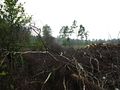
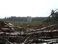
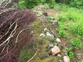
Drove up to Hallaröd to find the forest road closed and about 1,5 kilometers walk back and forth to the geohash. Did see some clouds beginning to form above me so I took what I had in my car, a plastic bag, only big enough to protect the camera and started walking (quickly). Not very far from the car a heavy rain started to pour down. I took shelter under some trees but after waiting for close to 10 minutes I realized that it would not go away and I was expected home very soon, so I started to walk/run through the rain to the geohash. When arriving I was completely soaked and I found the geohash location almost to be in the farmed trees close to the road, but luckily I got behind the trees and located the geohash. Took some photos, although the modern mobile phone does not work when wet, the fingertips cannot be sensed, I managed to protect the phone with my body so the necessary pictures was taken. Then returned quickly to the car and drove home for a change of clothes.
Photos

The grin
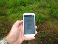
Proof

Proof
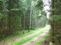
Road to geohash
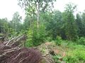
North
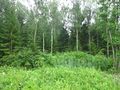
East
South
West
On this spot = geohash


Achievements
Llavids earned the Land geohash achievement
|
Llavids earned the Consecutive geohash achievement
|