Difference between revisions of "2012-07-21 50 14"
imported>Urcher (Created page with "{{subst:Expedition |lat = latitude of graticule |lon = longitude of graticule |date = date of expedition, in YYYY-MM-DD format }}") |
imported>FippeBot m (Location) |
||
| (One intermediate revision by one other user not shown) | |||
| Line 1: | Line 1: | ||
| + | [[Image:{{{image|2012-07-21 50 14 hashpoint.jpg}}}|thumb|left]] | ||
| − | |||
| − | |||
| − | |||
| − | |||
| − | |||
| − | |||
| − | |||
| − | |||
| − | |||
{{meetup graticule | {{meetup graticule | ||
| − | | lat= | + | | lat=50 |
| − | | lon= | + | | lon=14 |
| − | | date= | + | | date=2012-07-21}} |
| − | }} | ||
| − | |||
__NOTOC__ | __NOTOC__ | ||
== Location == | == Location == | ||
| − | + | Near Hlubočepy tram stop, Prague | |
== Participants == | == Participants == | ||
| − | + | [[User:Urcher|Urcher]], Bilby, and Doomhammer | |
| − | |||
== Plans == | == Plans == | ||
| − | + | Catch tram to Hlubočepy, walk 35m | |
== Expedition == | == Expedition == | ||
| − | + | Our journey began when Doomhammer awoke from his afternoon nap. We proceeded (in the manner of policemen) to Lipanska to catch tram 9, a quick change at Švandovo divadlo to tram 12 took us the rest of the way to Hlubočepy. The hashpoint was only 35m from the tram stop. Turned out to be in the middle of a small creek. We got within GPS accuracy (about 5m), close enough for us, time for afternoon tea. | |
| − | |||
| − | |||
| − | |||
== Photos == | == Photos == | ||
| − | |||
| − | |||
| − | |||
<gallery perrow="5"> | <gallery perrow="5"> | ||
| + | Image:2012-07-21 50 14 journey begins.jpg | The journey begins outside our apartment | ||
| + | Image:2012-07-21 50 14 tram change.jpg | A quick change of trams | ||
| + | Image:2012-07-21 50 14 Hlubocepy.jpg | On arrival at Hlubočepy, only 35m to go | ||
| + | Image:2012-07-21 50 14 evidence.jpg | The crucial evidence | ||
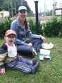
| + | Image:2012-07-21 50 14 hashpoint.jpg | Urcher, Bilby and Doomhammer at the hashpoint | ||
| + | Image:2012-07-21 50 14 creek.jpg | The creek that contained the hashpoint | ||
| + | Image:2012-07-21 50 14 building.jpg | The view from the hashpoint of a historical looking building that housed a restaurant | ||
| + | Image:2012-07-21 50 14 picnic.jpg | Picnic at the hashpoint, bang on 4pm | ||
</gallery> | </gallery> | ||
== Achievements == | == Achievements == | ||
{{#vardefine:ribbonwidth|800px}} | {{#vardefine:ribbonwidth|800px}} | ||
| − | + | {{land geohash | |
| + | |||
| + | | latitude = 50 | ||
| + | | longitude = 14 | ||
| + | | date = 2012-07-21 | ||
| + | | name = Urcher | ||
| + | |||
| + | }} | ||
| + | {{Public transport geohash | ||
| + | |||
| + | | latitude = 50 | ||
| + | | longitude = 14 | ||
| + | | date = 2012-07-21 | ||
| + | | busline = Tram 12 | ||
| + | | name = Urcher | ||
| + | }} | ||
| + | {{Picnic_geohash | ||
| − | + | | latitude = 50 | |
| − | + | | longitude = 14 | |
| − | + | | date = 2012-07-21 | |
| + | | name = Urcher | ||
| + | | image = 2012-07-21 50 14 picnic.jpg | ||
| + | | food = Carrot cake and honey & walnut cake from the Jiřího z Poděbrad farmers market, gingerbread from Nurenberg, pistacio biscuit from Marks and Spencer | ||
| − | + | }} | |
| − | |||
| − | |||
| − | |||
| − | |||
[[Category:Expeditions]] | [[Category:Expeditions]] | ||
| − | |||
[[Category:Expeditions with photos]] | [[Category:Expeditions with photos]] | ||
| − | |||
| − | |||
| − | |||
| − | |||
| − | |||
[[Category:Coordinates reached]] | [[Category:Coordinates reached]] | ||
| − | + | {{location|CZ|PR}} | |
| − | |||
| − | |||
| − | |||
| − | |||
| − | |||
| − | |||
| − | |||
| − | |||
| − | |||
| − | |||
| − | |||
| − | |||
| − | |||
| − | |||
| − | |||
| − | |||
| − | |||
Latest revision as of 05:09, 13 August 2019

| Sat 21 Jul 2012 in 50,14: 50.0420860, 14.4041931 geohashing.info google osm bing/os kml crox |
Location
Near Hlubočepy tram stop, Prague
Participants
Urcher, Bilby, and Doomhammer
Plans
Catch tram to Hlubočepy, walk 35m
Expedition
Our journey began when Doomhammer awoke from his afternoon nap. We proceeded (in the manner of policemen) to Lipanska to catch tram 9, a quick change at Švandovo divadlo to tram 12 took us the rest of the way to Hlubočepy. The hashpoint was only 35m from the tram stop. Turned out to be in the middle of a small creek. We got within GPS accuracy (about 5m), close enough for us, time for afternoon tea.
Photos

The journey begins outside our apartment
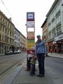
A quick change of trams

On arrival at Hlubočepy, only 35m to go
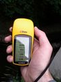
The crucial evidence
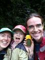
Urcher, Bilby and Doomhammer at the hashpoint

The creek that contained the hashpoint
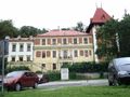
The view from the hashpoint of a historical looking building that housed a restaurant
Picnic at the hashpoint, bang on 4pm


Achievements
Urcher earned the Land geohash achievement
|
Urcher earned the Public transport geohash achievement
|
Urcher earned the Picnic achievement
|