2012-07-22 32 -116
From Geohashing
Revision as of 05:10, 13 August 2019 by imported>FippeBot (Location)
| Sun 22 Jul 2012 in 32,-116: 32.5994754, -116.7209116 geohashing.info google osm bing/os kml crox |
Location
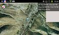
On a hillside south of Campo Road
Participants
Expedition
The closest vehicular approach was about 600 meters north of the hashpoint; proceeding south by foot, the hashers encountered a dense riparian zone. After about 200 meters of this, the plants became too thick to penetrate and the expedition was called off.
Photos

Closest approach
Closest approach

