2012-07-27 52 4
| Fri 27 Jul 2012 in 52,4: 52.2910436, 4.6299855 geohashing.info google osm bing/os kml crox |
Location
Haarlemmermeer, in a field about 50m from the road just next to a small ditch (may have to jump it).
Looks a possible, trespassing? Just act if you belong! Always works ;-)
Participants
Palmpje may be there... depends a bit on work (can I take the afternoon off?) and beach weather (should I improve the all-over tan?)
Murfie has also plans. Probably go there around noon.
Plans
Drive out there and see if I can get to the hashpoint. Remember to program GPSr with coordinates, select hashcot!
Expedition
- Palmpje
I decided for lunch on the beach. Then bicycled back home and got the geohashing/caching gear and drove to the hashpoint. Had to be careful as the map shows intersections, bit sometimes one raod just crosses the other as a bridge with no way to take a turn. When I got there I quickly lost hope to reach the hashpoint. Fields were planted right to the edge and the ditch was not really wide but had really steep sides. Also, I was only wearing a pair of slippers on my feet (almost did the hobbit thing but a cornfield is not the place to walk barefoot). Got to 9m from the cache and glad I came. As a consolation I decided to hunt for two geocaches nearby.
Tracklog
Photos
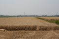
View from the road
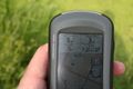
Close, but not quite there
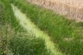
I'm not going to jump that
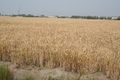
Hashpoint


Achievements
Is it true that Palmpje earned the Cliffs of despair consolation prize?
|