Difference between revisions of "2012-07-28 32 -116"
From Geohashing
imported>LucasBrown |
imported>FippeBot m (Location) |
||
| (3 intermediate revisions by 2 users not shown) | |||
| Line 10: | Line 10: | ||
== Participants == | == Participants == | ||
| − | [[User:LucasBrown|LucasBrown]] | + | * [[User:LucasBrown|LucasBrown]] |
== Photos == | == Photos == | ||
<gallery perrow="5"> | <gallery perrow="5"> | ||
| − | |||
Image:2012-07-28_32_-116_18-24-48-904.jpg | Geohash Droid screenshot at the hashpoint | Image:2012-07-28_32_-116_18-24-48-904.jpg | Geohash Droid screenshot at the hashpoint | ||
| − | |||
Image:2012-07-28_32_-116_18-33-55-850.jpg | Canine at the hashpoint | Image:2012-07-28_32_-116_18-33-55-850.jpg | Canine at the hashpoint | ||
| − | |||
Image:2012-07-28_32_-116_18-35-47-968.jpg | The hashpoint was reached by pushing through the dense brush between the hashpoint and the northern path. | Image:2012-07-28_32_-116_18-35-47-968.jpg | The hashpoint was reached by pushing through the dense brush between the hashpoint and the northern path. | ||
</gallery> | </gallery> | ||
== Achievements == | == Achievements == | ||
| − | |||
| − | |||
| − | + | *Land Geohash | |
| + | |||
| + | |||
[[Category:Expeditions]] | [[Category:Expeditions]] | ||
[[Category:Expeditions with photos]] | [[Category:Expeditions with photos]] | ||
| − | |||
[[Category:Coordinates reached]] | [[Category:Coordinates reached]] | ||
| + | {{location|US|CA|SD}} | ||
Latest revision as of 05:15, 13 August 2019
| Sat 28 Jul 2012 in 32,-116: 32.6893290, -116.5047874 geohashing.info google osm bing/os kml crox |
Location
Near the Pacific Crest Trail in San Diego County's "Mountain Empire" district
Participants
Photos
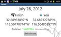
Geohash Droid screenshot at the hashpoint

Canine at the hashpoint
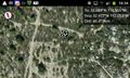
The hashpoint was reached by pushing through the dense brush between the hashpoint and the northern path.


Achievements
- Land Geohash