Difference between revisions of "2012-07-28 47 -117"
imported>Thomcat ([live picture] [http://www.openstreetmap.org/?lat=47.68939589&lon=-117.50477128&zoom=16&layers=B000FTF @47.6894,-117.5048]) |
imported>Thomcat (Expedition details) |
||
| Line 16: | Line 16: | ||
== Expedition == | == Expedition == | ||
| − | + | *Parked near the spot. -- [[User:Thomcat|Thomcat]] [http://www.openstreetmap.org/?lat=47.68946417&lon=-117.50487110&zoom=16&layers=B000FTF @47.6895,-117.5049] 15:58, 28 July 2012 (PDT) -- a Saturday Meetup! | |
| + | Didn't bring any sidewalk chalk. Before parking next to the spot, we actually went a little further up the road to snap a picture for the graticule page - Spokane from the bluff looks like the little town that it acts like, not the big city that it so wants to be. This was also a great spot to watch Independence Day fireworks, back when I was younger. | ||
| − | + | Back to the spot and park across the road. Aerial photo showed it to be on the verge of the road, but the geohash droid wanted to drag me up the bank and into the private property. I was having none of that, and even reset the GPS to see if I could get a better reading. | |
| − | + | ||
| − | + | Going back and looking at the aerial photo and my photos, I trekked back and forth over the spot a few times. The rock marked below was just off the road, between the actual spot and where the droid GPS wanted me to go. | |
| + | |||
| + | Absolutely nobody showed up, it was a hot day (but not my hottest geohash) and there were other tasks to accomplish. Considering that I am the first to edit the Spokane graticule page in roughly 3 years, I will confirm this graticule is IN-ACTIVE. | ||
| + | |||
| + | At least until my next trip through. | ||
== Photos == | == Photos == | ||
| − | |||
| − | |||
| − | |||
<gallery perrow="5"> | <gallery perrow="5"> | ||
| + | Image:2012-07-28 47 -117 InCar.jpg | Parked across the road from the point | ||
| + | Image:2012-07-28 47 -117 OutCar.jpg | The car, standing close to the spot. Note the crack in the road and the crack on the aerial photo. The geohash dance has me a little NE of the spot, I think. | ||
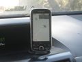
| + | Image:2012-07-28_47_-117_16-03-48-097.jpg | Photo from disoriented geohash droid; the hash point is *not* on private property. [http://www.openstreetmap.org/?lat=47.68937653&lon=-117.50480489&zoom=16&layers=B000FTF @47.6894,-117.5048] | ||
| + | Image:2012-07-28 47 -117 Geohasher.jpg | Standing close to the spot. Note the pole in the background, and also on the aerial photo | ||
| + | Image:2012-07-28_47_-117_16-10-12-584.jpg | A rock I plainly marked. [http://www.openstreetmap.org/?lat=47.68939589&lon=-117.50477128&zoom=16&layers=B000FTF @47.6894,-117.5048] | ||
| − | |||
| − | |||
| − | |||
</gallery> | </gallery> | ||
| − | |||
| − | |||
| − | |||
| − | |||
| − | |||
| − | |||
| − | |||
| − | |||
| − | |||
| − | |||
| − | |||
| − | |||
| − | |||
| − | |||
| − | |||
[[Category:Expeditions]] | [[Category:Expeditions]] | ||
| − | |||
[[Category:Expeditions with photos]] | [[Category:Expeditions with photos]] | ||
| − | |||
| − | |||
| − | |||
| − | |||
| − | |||
[[Category:Coordinates reached]] | [[Category:Coordinates reached]] | ||
| − | |||
| − | |||
| − | |||
| − | |||
| − | |||
| − | |||
| − | |||
| − | |||
| − | |||
| − | |||
| − | |||
| − | |||
| − | |||
| − | |||
| − | |||
| − | |||
| − | |||
| − | |||
Revision as of 16:04, 30 July 2012
| Sat 28 Jul 2012 in 47,-117: 47.6893290, -117.5047874 geohashing.info google osm bing/os kml crox |
Location
On Indian Bluff Road, overlooking Spokane.
Participants
Plans
I plan to arrive at 4 with sidewalk chalk in hand. --Thomcat 10:13, 27 July 2012 (EDT)
Expedition
- Parked near the spot. -- Thomcat @47.6895,-117.5049 15:58, 28 July 2012 (PDT) -- a Saturday Meetup!
Didn't bring any sidewalk chalk. Before parking next to the spot, we actually went a little further up the road to snap a picture for the graticule page - Spokane from the bluff looks like the little town that it acts like, not the big city that it so wants to be. This was also a great spot to watch Independence Day fireworks, back when I was younger.
Back to the spot and park across the road. Aerial photo showed it to be on the verge of the road, but the geohash droid wanted to drag me up the bank and into the private property. I was having none of that, and even reset the GPS to see if I could get a better reading.
Going back and looking at the aerial photo and my photos, I trekked back and forth over the spot a few times. The rock marked below was just off the road, between the actual spot and where the droid GPS wanted me to go.
Absolutely nobody showed up, it was a hot day (but not my hottest geohash) and there were other tasks to accomplish. Considering that I am the first to edit the Spokane graticule page in roughly 3 years, I will confirm this graticule is IN-ACTIVE.
At least until my next trip through.
Photos
Parked across the road from the point
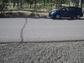
The car, standing close to the spot. Note the crack in the road and the crack on the aerial photo. The geohash dance has me a little NE of the spot, I think.
Photo from disoriented geohash droid; the hash point is *not* on private property. @47.6894,-117.5048
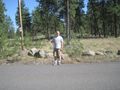
Standing close to the spot. Note the pole in the background, and also on the aerial photo
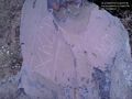
A rock I plainly marked. @47.6894,-117.5048


