Difference between revisions of "2012-08-03 46 -123"
imported>Thomcat (Midnight at the Mima Mounds...) |
imported>FippeBot m (Location) |
||
| (4 intermediate revisions by one other user not shown) | |||
| Line 16: | Line 16: | ||
== Expedition == | == Expedition == | ||
| − | + | Drove south under clear skies and a mostly full moon. From the highway the tall trees necessitated the use of brights. The development just south of the hash point was sparsely lit, with few fences. | |
| − | + | There was a fence around the area with the geohash... so I drove past to see the house that now intrudes on the track. I backed into the driveway to turn around and snapped a pic of the GPS. Coming back, I spotted a gap in the fence - meant to be driven into. Score! | |
| − | |||
| − | + | Just beyond were the two buildings visible on the aerial photo. The track wasn't dirt, but overgrown grasses. I parked, took the GeohashDroid and the camera. The moonlight was enough to see by and the track was straight - dead straight. 300 meters to go to the hash point, which was off to the left in the middle of the track. | |
| − | |||
| − | |||
| − | |||
| − | |||
| − | |||
| − | + | I reached the appropriate point to turn off but the hummocks of dirt and brush were in the way, so I backtracked a little to a gap. This was a little dicier under the full moon, and I didn't bring a flashlight. Going slowly, I picked my way around the brush to find the spot. | |
| − | |||
| − | |||
| + | While the track was solid and grass, the off track was some sort of dried sponge. Quite unnerving to step down and sink in another 2-3 inches. Too far to go back, but I'll bet I left definite tracks. | ||
| − | + | Two hummocks or brush mounds and I reached my first Astoria Geohash. I couldn't send a geohashdroid live note, as I had no service. | |
| − | |||
| − | |||
| − | + | Not far from here is a famous ghost town (and this track is likely to be related), but I won't visit a ghost town after midnight, in the dark, without a flashlight. | |
| − | |||
| − | |||
| − | |||
| − | + | Returning to the car, I rolled down the window to snap a few pictures of the gap and the two buildings. That's when the howling of coyotes began. | |
| − | |||
| − | |||
| − | |||
| − | |||
| − | |||
| − | |||
| − | |||
| − | |||
| − | |||
| + | Driving around the corner to check out for other entrances to the area, I finally got service again, and sent | ||
| − | -- | + | *Heading home -- [[User:Thomcat|Thomcat]] [http://www.openstreetmap.org/?lat=46.88638230&lon=-123.04768178&zoom=16&layers=B000FTF @46.8864,-123.0477] 00:20, 4 August 2012 (PDT) |
| − | [[ | ||
| − | |||
| − | |||
| − | |||
| − | |||
| − | |||
| − | |||
| − | + | == Photos == | |
| − | + | <gallery perrow="4"> | |
| − | + | Image:2012-08-03_46_-123_Underweay.jpg | Underway! | |
| − | + | Image:2012-08-03_46_-123_YouAreThere.jpg | On the spot | |
| − | + | Image:2012-08-03_46_-123_Geohasher.jpg | Grin | |
| + | Image:2012-08-03_46_-123_Hummocks.jpg | Between the Hummocks | ||
| + | Image:2012-08-03_46_-123_Racetrack.jpg | Straight tracks | ||
| + | Image:2012-08-03_46_-123_NotATrackLog.jpg | Approximate path | ||
| + | Image:2012-08-03_46_-123_Bordeaux.jpg | About the area - Coyotes! Bears! | ||
| + | </gallery> | ||
| + | |||
| + | == Achievements == | ||
| + | {{Midnight geohash | ||
| + | | latitude = 46 | ||
| + | | longitude = -123 | ||
| + | | date = 2012-08-03 | ||
| + | | name = Thomcat | ||
| + | | image = 2012-08-03_46_-123_Geohasher.jpg | ||
| + | }} | ||
| + | and "Bonus points if you achieve this without a light source" apply. Woot! | ||
| − | + | [[Category:Expeditions]] | |
| + | [[Category:Expeditions with photos]] | ||
| + | [[Category:Coordinates reached]] | ||
| + | {{location|US|WA|TH}} | ||
Latest revision as of 05:22, 13 August 2019
| Fri 3 Aug 2012 in 46,-123: 46.8850048, -123.0530051 geohashing.info google osm bing/os kml crox |
Location
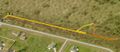
Inside a now defunct race track just south of Mima Mounds.
Participants
Plans
Heading down there at midnight, under clear skies and a full moon.
Expedition
Drove south under clear skies and a mostly full moon. From the highway the tall trees necessitated the use of brights. The development just south of the hash point was sparsely lit, with few fences.
There was a fence around the area with the geohash... so I drove past to see the house that now intrudes on the track. I backed into the driveway to turn around and snapped a pic of the GPS. Coming back, I spotted a gap in the fence - meant to be driven into. Score!
Just beyond were the two buildings visible on the aerial photo. The track wasn't dirt, but overgrown grasses. I parked, took the GeohashDroid and the camera. The moonlight was enough to see by and the track was straight - dead straight. 300 meters to go to the hash point, which was off to the left in the middle of the track.
I reached the appropriate point to turn off but the hummocks of dirt and brush were in the way, so I backtracked a little to a gap. This was a little dicier under the full moon, and I didn't bring a flashlight. Going slowly, I picked my way around the brush to find the spot.
While the track was solid and grass, the off track was some sort of dried sponge. Quite unnerving to step down and sink in another 2-3 inches. Too far to go back, but I'll bet I left definite tracks.
Two hummocks or brush mounds and I reached my first Astoria Geohash. I couldn't send a geohashdroid live note, as I had no service.
Not far from here is a famous ghost town (and this track is likely to be related), but I won't visit a ghost town after midnight, in the dark, without a flashlight.
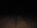
Returning to the car, I rolled down the window to snap a few pictures of the gap and the two buildings. That's when the howling of coyotes began.
Driving around the corner to check out for other entrances to the area, I finally got service again, and sent
- Heading home -- Thomcat @46.8864,-123.0477 00:20, 4 August 2012 (PDT)
Photos
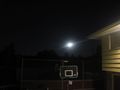
Underway!
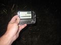
On the spot

Grin
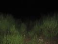
Between the Hummocks
Straight tracks
Approximate path
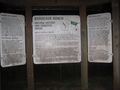
About the area - Coyotes! Bears!


Achievements
Thomcat earned the Midnight Geohash achievement
|
and "Bonus points if you achieve this without a light source" apply. Woot!