Difference between revisions of "2012-08-04 19 -155"
From Geohashing
imported>Simonradford |
imported>FippeBot m (Location) |
||
| (One intermediate revision by one other user not shown) | |||
| Line 43: | Line 43: | ||
--> | --> | ||
<gallery perrow="5"> | <gallery perrow="5"> | ||
| − | Image:2012_08_04_19_- | + | Image:2012_08_04_19_-155_a.png | GPS display. |
| − | Image:2012_08_04_19_- | + | Image:2012_08_04_19_-155_b.jpg | Mauna Kea behind me. |
| − | Image:2012_08_04_19_- | + | Image:2012_08_04_19_-155_c.jpg | 'Ohelo berries. |
| − | Image:2012_08_04_19_- | + | Image:2012_08_04_19_-155_d.jpg | Mauna Loa lava flows, pahoehoe and 'a'a. |
</gallery> | </gallery> | ||
| Line 64: | Line 64: | ||
[[Category:Expeditions with photos]] | [[Category:Expeditions with photos]] | ||
[[Category:Coordinates reached]] | [[Category:Coordinates reached]] | ||
| + | {{location|US|HI|HA}} | ||
Latest revision as of 05:23, 13 August 2019
| Sat 4 Aug 2012 in 19,-155: 19.6396922, -155.4799171 geohashing.info google osm bing/os kml crox |
Location
On a pahoehoe lava flow (1850s?) in the Saddle between Mauna Loa and Mauna Kea. Close to the margin of a more recent 'a'a lava flow (1936?). A little way off the road to the Mauna Loa Observatory.
Participants
Plans
No plans. Spontaneity rules.
Expedition
Drove up the Mauna Loa road from the Saddle highway and broke out of the mist coming up from the windward side. After parking at a turnout, took a short stroll across the lava. Glad it was a pahoehoe flow as walking over an 'a'a flow would have been less fun. Lots of berries on the 'ohelo bushes. Nice views of Mauna Kea.
Tracklog
Photos
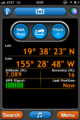
GPS display.

Mauna Kea behind me.
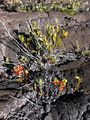
'Ohelo berries.
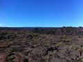
Mauna Loa lava flows, pahoehoe and 'a'a.


Achievements
Simon earned the West geohash achievement
|