Difference between revisions of "2012-08-04 47 -122"
imported>OtherJack m (→Photos) |
imported>FippeBot m (Location) |
||
| (10 intermediate revisions by 3 users not shown) | |||
| Line 15: | Line 15: | ||
== Participants == | == Participants == | ||
| + | |||
* [[User:Thomcat|Thomcat]] | * [[User:Thomcat|Thomcat]] | ||
* [[User:OtherJack|OtherJack]] | * [[User:OtherJack|OtherJack]] | ||
== Plans == | == Plans == | ||
| − | + | ||
4pm | 4pm | ||
== Expedition == | == Expedition == | ||
| − | + | ||
It was the warmest day of the year so far, with an evening high of 93F (about 34C). After a lazy afternoon celebrating this by hanging out and swimming in the considerably colder Sound with friends at Golden Gardens beach, [[User:OtherJack|OtherJack]] headed back east towards the alternate meetup by bike around 3:30. He knew of the several steep climbs that lay on the route, but still underestimated them and ended up rolling into a little-used corner of Licton Springs park at 4:10. In hindsight, perhaps part of the delay was also owing to his unplanned stop in the middle of the first of those climbs to listen to and thank a couple of musicians who (for some reason) were playing some excellent free-jazz in a clearing by the side of the Golden Gardens road. | It was the warmest day of the year so far, with an evening high of 93F (about 34C). After a lazy afternoon celebrating this by hanging out and swimming in the considerably colder Sound with friends at Golden Gardens beach, [[User:OtherJack|OtherJack]] headed back east towards the alternate meetup by bike around 3:30. He knew of the several steep climbs that lay on the route, but still underestimated them and ended up rolling into a little-used corner of Licton Springs park at 4:10. In hindsight, perhaps part of the delay was also owing to his unplanned stop in the middle of the first of those climbs to listen to and thank a couple of musicians who (for some reason) were playing some excellent free-jazz in a clearing by the side of the Golden Gardens road. | ||
| Line 32: | Line 33: | ||
After the customary geohashing conversation (why has the algorithm been so bad to us lately, how badass are/aren't we compared to nearby graticules, etc...) the hashers parted ways and returned to their respective homes nearby. Another successful alternate meetup. | After the customary geohashing conversation (why has the algorithm been so bad to us lately, how badass are/aren't we compared to nearby graticules, etc...) the hashers parted ways and returned to their respective homes nearby. Another successful alternate meetup. | ||
| − | == | + | == Photos == |
| − | |||
| − | |||
| − | |||
| − | |||
| − | |||
<gallery perrow="5"> | <gallery perrow="5"> | ||
| − | |||
Image:2012-08-04_47_-122_16-10-17-959.jpg | Licton Springs - the Iron Spring. Waiting for others. [http://www.openstreetmap.org/?lat=47.69918775&lon=-122.33916413&zoom=16&layers=B000FTF @47.6992,-122.3392] | Image:2012-08-04_47_-122_16-10-17-959.jpg | Licton Springs - the Iron Spring. Waiting for others. [http://www.openstreetmap.org/?lat=47.69918775&lon=-122.33916413&zoom=16&layers=B000FTF @47.6992,-122.3392] | ||
Image:2012-08-04 IMG 3142.JPG | Others arrive and postulate that the Iron Spring also appears to be the <s>Iron</s> Concrete Keyhole to... Ironland. Or somewhere. | Image:2012-08-04 IMG 3142.JPG | Others arrive and postulate that the Iron Spring also appears to be the <s>Iron</s> Concrete Keyhole to... Ironland. Or somewhere. | ||
| Line 50: | Line 45: | ||
== Achievements == | == Achievements == | ||
{{#vardefine:ribbonwidth|800px}} | {{#vardefine:ribbonwidth|800px}} | ||
| + | |||
* [[User:Thomcat|Thomcat]]'s 10th Saturday meetup. | * [[User:Thomcat|Thomcat]]'s 10th Saturday meetup. | ||
| + | == Way-too-late post-expedition epiphany == | ||
| − | + | When I was at Golden Gardens before the meetup, I actually had a direct line-of-sight to the hashpoint several miles offshore!! See the map, you can draw a straight line from the hash to Golden Gardens over water alone. If I'd realized this I could have snapped a picture of it, or at least of its general vicinity, with the Olympics in the background. Bah. -- [[User:OtherJack|OtherJack]] 03:25, 6 August 2012 (EDT) | |
| − | |||
| − | [[ | ||
| − | |||
| − | |||
| − | |||
| − | |||
| − | |||
| − | |||
[[Category:Expeditions]] | [[Category:Expeditions]] | ||
| − | |||
[[Category:Expeditions with photos]] | [[Category:Expeditions with photos]] | ||
| − | |||
| − | |||
| − | |||
| − | |||
| − | |||
| − | |||
| − | |||
| − | |||
| − | |||
[[Category:Coordinates not reached]] | [[Category:Coordinates not reached]] | ||
| − | + | [[Category:Not reached - Attended alternate location]] | |
| − | + | {{location|US|WA|KS}} | |
| − | |||
| − | |||
| − | |||
| − | [[Category:Not reached - | ||
| − | |||
| − | |||
| − | |||
| − | |||
| − | |||
| − | |||
| − | |||
| − | |||
Latest revision as of 05:24, 13 August 2019
| Sat 4 Aug 2012 in 47,-122: 47.6396922, -122.4799171 geohashing.info google osm bing/os kml crox |
Location
In the waters of Puget Sound, yet again.
Alternate Location
The spring in Licton Springs Park.
Licton Springs park is an Iron Spring in North Seattle. You can read more about it here.
Participants
Plans
4pm
Expedition
It was the warmest day of the year so far, with an evening high of 93F (about 34C). After a lazy afternoon celebrating this by hanging out and swimming in the considerably colder Sound with friends at Golden Gardens beach, OtherJack headed back east towards the alternate meetup by bike around 3:30. He knew of the several steep climbs that lay on the route, but still underestimated them and ended up rolling into a little-used corner of Licton Springs park at 4:10. In hindsight, perhaps part of the delay was also owing to his unplanned stop in the middle of the first of those climbs to listen to and thank a couple of musicians who (for some reason) were playing some excellent free-jazz in a clearing by the side of the Golden Gardens road.
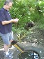
In any case, a random foray into the woods failed to produce any springs or Thoms, so Jack asked directions of various park-goers until he was finally riding down the right path. Presently on his right he spied a concrete lid on the ground with a 1-foot (30cm or so) diameter hole cut into it, looked kinda dirty and wet, no Thom. Can't be the iron spring, he thought, and rode on. But about ten seconds further down the path around a couple bends he found Thomcat lying on a picnic table reading a book, who quickly confirmed that in fact it was the spring the neighborhood was named after.
They proceeded to take a brief walking tour of the two (!) springs in the park, first continuing south to check out the magnesium spring which was hidden by a swamp, and then returning to the hole in the concrete, which turned out to be full of water that trickled out through a narrow cut channel which the dissolved iron had long since stained bright-orange. The tiny stream continued through the underbrush over an equally orange stream-bed, presumably ending up in the above swamp. See the photos...
After the customary geohashing conversation (why has the algorithm been so bad to us lately, how badass are/aren't we compared to nearby graticules, etc...) the hashers parted ways and returned to their respective homes nearby. Another successful alternate meetup.
Photos
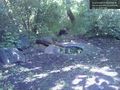
Licton Springs - the Iron Spring. Waiting for others. @47.6992,-122.3392
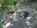
Others arrive and postulate that the Iron Spring also appears to be the
IronConcrete Keyhole to... Ironland. Or somewhere.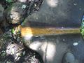
Closeup on the rusty outlet channel
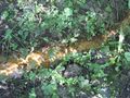
... and the rusty stream it feeds
Thom taking another photo


Achievements
- Thomcat's 10th Saturday meetup.
Way-too-late post-expedition epiphany
When I was at Golden Gardens before the meetup, I actually had a direct line-of-sight to the hashpoint several miles offshore!! See the map, you can draw a straight line from the hash to Golden Gardens over water alone. If I'd realized this I could have snapped a picture of it, or at least of its general vicinity, with the Olympics in the background. Bah. -- OtherJack 03:25, 6 August 2012 (EDT)