Difference between revisions of "2012-08-11 32 -116"
imported>LucasBrown m |
imported>FippeBot m (Location) |
||
| (9 intermediate revisions by 2 users not shown) | |||
| Line 17: | Line 17: | ||
== Expedition == | == Expedition == | ||
| − | * | + | *Currently at home, waiting for the day to cool down before attempting the hash. Today's attempt came vey close to not happening due to a kidney stone, but fortunately the episode did not last long. -- [[User:LucasBrown|LucasBrown]] [http://www.openstreetmap.org/?lat=32.97690301&lon=-117.05282798&zoom=16&layers=B000FTF @32.9769,-117.0528] 13:40, 11 August 2012 (PDT) |
| − | + | ||
| − | + | Upon reaching the wash containing the hashpoint, the weather had become somewhat inclement—thunderstorms with light precipitation and a temperature of about 30°C. The lightning would interfere with the GPS signals and was frequent enough that my phone couldn't get a good-enough bearing on my position to yield an error of less than 100 meters or so. I called it good enough once I had a reading that put me within 60 meters of the hashpoint. | |
| + | |||
== Photos == | == Photos == | ||
<gallery perrow="5"> | <gallery perrow="5"> | ||
| + | |||
| + | Image:2012-08-11_32_-116_23-07-55-102.jpg | Geohash Droid details page at the "good enough" point | ||
</gallery> | </gallery> | ||
| Line 28: | Line 31: | ||
{{#vardefine:ribbonwidth|800px}} | {{#vardefine:ribbonwidth|800px}} | ||
<!-- Add any achievement ribbons you earned below, or remove this section --> | <!-- Add any achievement ribbons you earned below, or remove this section --> | ||
| + | This is part 2 of a consecutive geohash spree beginning with the hasher's 24th expedition | ||
| − | |||
| − | |||
| − | |||
| − | |||
| − | |||
| − | |||
| − | |||
| − | |||
| − | |||
| − | |||
[[Category:Expeditions]] | [[Category:Expeditions]] | ||
| − | |||
[[Category:Expeditions with photos]] | [[Category:Expeditions with photos]] | ||
| − | |||
| − | |||
| − | |||
| − | |||
| − | |||
[[Category:Coordinates reached]] | [[Category:Coordinates reached]] | ||
| − | + | {{location|US|CA|SD}} | |
| − | |||
| − | |||
| − | |||
| − | |||
| − | |||
| − | |||
| − | |||
| − | |||
| − | |||
| − | |||
| − | |||
| − | |||
| − | |||
| − | |||
| − | |||
| − | |||
| − | |||
Latest revision as of 05:31, 13 August 2019
| Sat 11 Aug 2012 in 32,-116: 32.7118274, -116.5016661 geohashing.info google osm bing/os kml crox |
Location
300m west of the Pacific Crest Trail, 200m east of Morena Stokes Valley Road, and 400m southwest of Buckman Springs Road
Participants
Plans
Drive out along SR67 and I8 once the day cools down a bit
Expedition
- Currently at home, waiting for the day to cool down before attempting the hash. Today's attempt came vey close to not happening due to a kidney stone, but fortunately the episode did not last long. -- LucasBrown @32.9769,-117.0528 13:40, 11 August 2012 (PDT)
Upon reaching the wash containing the hashpoint, the weather had become somewhat inclement—thunderstorms with light precipitation and a temperature of about 30°C. The lightning would interfere with the GPS signals and was frequent enough that my phone couldn't get a good-enough bearing on my position to yield an error of less than 100 meters or so. I called it good enough once I had a reading that put me within 60 meters of the hashpoint.
Photos
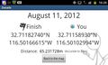
Geohash Droid details page at the "good enough" point

Achievements
This is part 2 of a consecutive geohash spree beginning with the hasher's 24th expedition