Difference between revisions of "2012-08-12 33 -116"
From Geohashing
imported>LucasBrown (→Achievements) |
imported>FippeBot m (Location) |
||
| (2 intermediate revisions by 2 users not shown) | |||
| Line 1: | Line 1: | ||
| − | |||
| − | |||
| − | |||
| − | |||
| − | |||
| − | |||
| − | |||
| − | |||
| − | |||
| − | |||
{{meetup graticule | {{meetup graticule | ||
| lat=33 | | lat=33 | ||
| Line 15: | Line 5: | ||
}} | }} | ||
| − | |||
__NOTOC__ | __NOTOC__ | ||
== Location == | == Location == | ||
| − | + | ''On a hillside SE of Valley Center, CA'' | |
== Participants == | == Participants == | ||
| Line 24: | Line 13: | ||
== Expedition == | == Expedition == | ||
| − | + | ''He reached the hashpoint. Aparently, with a rubber chicken in tow.'' | |
== Photos == | == Photos == | ||
| − | |||
| − | |||
| − | |||
<gallery perrow="5"> | <gallery perrow="5"> | ||
| Line 47: | Line 33: | ||
== Achievements == | == Achievements == | ||
{{#vardefine:ribbonwidth|800px}} | {{#vardefine:ribbonwidth|800px}} | ||
| + | {{land geohash | latitude = 33 | longitude = -116 | date = 2012-08-12 | name = [[User:LucasBrown|LucasBrown]]}} | ||
This is part 3 of a consecutive geohash spree beginning with [[User:LucasBrown|LucasBrown's expedition #24]] | This is part 3 of a consecutive geohash spree beginning with [[User:LucasBrown|LucasBrown's expedition #24]] | ||
| − | + | ||
[[Category:Expeditions]] | [[Category:Expeditions]] | ||
[[Category:Expeditions with photos]] | [[Category:Expeditions with photos]] | ||
| − | |||
[[Category:Coordinates reached]] | [[Category:Coordinates reached]] | ||
| + | {{location|US|CA|SD}} | ||
Latest revision as of 05:32, 13 August 2019
| Sun 12 Aug 2012 in 33,-116: 33.1868606, -116.9329124 geohashing.info google osm bing/os kml crox |
Location
On a hillside SE of Valley Center, CA
Participants
Expedition
He reached the hashpoint. Aparently, with a rubber chicken in tow.
Photos
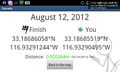
Geohash Droid details page at the hashpoint @33.1869,-116.9330
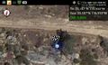
Geohash Droid map at the hashpoint @33.1868,-116.9330
Rubber chicken at the hashpoint @33.1868,-116.9330
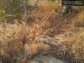
The rocks near the hashpoint @33.1868,-116.9330
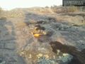
The rocks near the hashpoint. Six-inch rubber chicken for scale. @33.1868,-116.9330
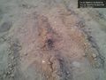
Stink bug near the hashpoint @33.1869,-116.9332


Achievements
LucasBrown earned the Land geohash achievement
|
This is part 3 of a consecutive geohash spree beginning with LucasBrown's expedition #24