Difference between revisions of "2012-08-15 -35 149"
imported>1PE (→Photos) |
m (More specific location) |
||
| (3 intermediate revisions by 3 users not shown) | |||
| Line 1: | Line 1: | ||
| − | |||
| − | [[Image:{{{image| | + | [[Image:{{{image|2012-08-15 -35 149 gate.JPG|}}}|thumb|left]] |
| − | |||
| − | |||
| − | |||
| − | |||
| − | |||
{{meetup graticule | {{meetup graticule | ||
| lat=-35 | | lat=-35 | ||
| Line 52: | Line 46: | ||
<!-- Add any achievement ribbons you earned below, or remove this section --> | <!-- Add any achievement ribbons you earned below, or remove this section --> | ||
Unlikely | Unlikely | ||
| − | |||
| − | |||
[[Category:Expeditions]] | [[Category:Expeditions]] | ||
[[Category:Expeditions with photos]] | [[Category:Expeditions with photos]] | ||
| − | |||
[[Category:Coordinates not reached]] | [[Category:Coordinates not reached]] | ||
[[Category:Not reached - No public access]] | [[Category:Not reached - No public access]] | ||
| + | {{location|AU|NSW|QB}} | ||
Latest revision as of 12:20, 1 August 2020

| Wed 15 Aug 2012 in -35,149: -35.3082822, 149.4382585 geohashing.info google osm bing/os kml crox |
Location
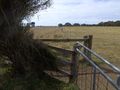
A paddock immediately east of the Hoskinstown Road, about 4km south of Bungendore. The hash is in clear ground near trees.
Participants
Plans
1PE (Canberra)
Lunchtime from work in Canberra, about 25-30 minutes drive from my work. I plan to leave an ActiveGeohashing.com poster on an adjacent tree. The property/house is not evident from the overhead pictures. This is probably sheep country, but I'll look out for larger animals before crossing the fence.
Expedition
1PE (Canberra)
I drove to Hoskinstown Road from Bungendore and picked up the landmarks first time (circular lawn farm gantry, then tree line on the right). The paddock has a double row of fence, with barbed wire at the top and first row under that with mesh wire to the ground, and a cattle-zapper-fence wire that I did not care to test. The fences are well built and maintained, with taut wire. I was unable to get over/through the fence (standard method is to depress the second wire IF YOU CAN and slip under the top wire), so drove a little further to the end of the field where the map showed a gate and road. The gate is into the next field, and was locked, so I understood this as "no permission".
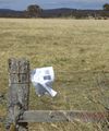
I fixed the ActiveGeohashing.com poster to the fence beside the lock, and took some pictures.
I returned "the other way", taking Hoskinstown Road to the south past the Molonglo Observatory Synthesis Telescope (MOST), a radio-telescope 6km south of the hash point.
Tracklog
Photos
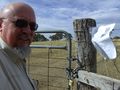
Say "barbed wire".
"[Sheep] to the left of me, [barbed wire fence] to the right, Here I am, stuck in the middle with [a locked gate]." (Apologies to Steelers Wheel) Hash beyond the trees in background.
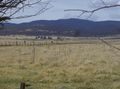
Farmhouse
Listening for ET? (radio-telescope)


Achievements
Unlikely