Difference between revisions of "2012-08-15 51 12"
From Geohashing
imported>Bazaruto (Created page with "{{subst:Expedition |lat = 51 |lon = 12 |date = 2012-08-15 }}") |
imported>FippeBot m (Location) |
||
| (6 intermediate revisions by one other user not shown) | |||
| Line 1: | Line 1: | ||
| + | <!-- If you did not specify these parameters in the template, please substitute appropriate values for IMAGE, LAT, LON, and DATE (YYYY-MM-DD format) --> | ||
| − | |||
| − | |||
| − | |||
| − | |||
| − | |||
| − | |||
| − | |||
| − | |||
| − | |||
{{meetup graticule | {{meetup graticule | ||
| lat=51 | | lat=51 | ||
| Line 19: | Line 11: | ||
== Location == | == Location == | ||
<!-- where you've surveyed the hash to be --> | <!-- where you've surveyed the hash to be --> | ||
| + | Leipzig Probstheida, near the "Parkkrankenhaus". | ||
== Participants == | == Participants == | ||
<!-- who attended: If you link to your wiki user name in this section, your expedition will be picked up by the various statistics generated for geohashing. You may use three tildes ~ as a shortcut to automatically insert the user signature of the account you are editing with. | <!-- who attended: If you link to your wiki user name in this section, your expedition will be picked up by the various statistics generated for geohashing. You may use three tildes ~ as a shortcut to automatically insert the user signature of the account you are editing with. | ||
--> | --> | ||
| − | + | [[User:Bazaruto|Bazaruto]] | |
| − | |||
| − | |||
== Expedition == | == Expedition == | ||
<!-- how it all turned out. your narrative goes here. --> | <!-- how it all turned out. your narrative goes here. --> | ||
| − | + | Hashpoint only 3km away and google maps showed a field of flowers. Lets walk there. It really was a field of flowers, but some to old and some to young - no gifts for my girlfriend. | |
| − | |||
| − | |||
== Photos == | == Photos == | ||
| Line 38: | Line 27: | ||
--> | --> | ||
<gallery perrow="5"> | <gallery perrow="5"> | ||
| + | Image:2012_08_15_51_12_flowers.JPG | flowers around hashpoint | ||
| + | Image:2012_08_15_51_12_hospital.JPG | hospital as seen from the hashpoint | ||
| + | Image:2012_08_15_51_12_point.JPG | marked hashpoint | ||
| + | Image:2012_08_15_51_12_grin.JPG | the grin | ||
</gallery> | </gallery> | ||
| Line 43: | Line 36: | ||
{{#vardefine:ribbonwidth|800px}} | {{#vardefine:ribbonwidth|800px}} | ||
<!-- Add any achievement ribbons you earned below, or remove this section --> | <!-- Add any achievement ribbons you earned below, or remove this section --> | ||
| − | + | {{Walk geohash | |
| + | | latitude = 51 | ||
| + | | longitude = 12 | ||
| + | | date = 2012-08-15 | ||
| + | | name = [[User:Bazaruto|Bazaruto]] | ||
| + | }} | ||
| + | {{No_batteries_geohash | latitude = 51 | longitude = 12 | date = 2012-08-15 | name = Bazaruto }} | ||
<!-- =============== USEFUL CATEGORIES FOLLOW ================ | <!-- =============== USEFUL CATEGORIES FOLLOW ================ | ||
| − | |||
| − | |||
<!-- Potential categories. Please include all the ones appropriate to your expedition --> | <!-- Potential categories. Please include all the ones appropriate to your expedition --> | ||
| − | |||
| − | |||
| − | |||
| − | |||
[[Category:Expeditions]] | [[Category:Expeditions]] | ||
| − | |||
[[Category:Expeditions with photos]] | [[Category:Expeditions with photos]] | ||
| − | |||
[[Category:Expedition without GPS]] | [[Category:Expedition without GPS]] | ||
| − | |||
| − | |||
| − | |||
[[Category:Coordinates reached]] | [[Category:Coordinates reached]] | ||
| − | + | {{location|DE|SN|L|city=true}} | |
| − | |||
| − | |||
| − | |||
| − | |||
| − | |||
| − | |||
| − | |||
| − | |||
| − | |||
| − | |||
| − | |||
| − | |||
| − | |||
| − | |||
| − | |||
| − | |||
| − | |||
Latest revision as of 05:35, 13 August 2019
| Wed 15 Aug 2012 in 51,12: 51.3082822, 12.4382585 geohashing.info google osm bing/os kml crox |
Location
Leipzig Probstheida, near the "Parkkrankenhaus".
Participants
Expedition
Hashpoint only 3km away and google maps showed a field of flowers. Lets walk there. It really was a field of flowers, but some to old and some to young - no gifts for my girlfriend.
Photos
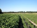
flowers around hashpoint
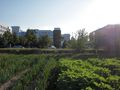
hospital as seen from the hashpoint
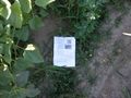
marked hashpoint
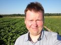
the grin


Achievements
Bazaruto earned the Walk geohash Achievement
|
Bazaruto earned the No Batteries Geohash Achievement
|