Difference between revisions of "2012-08-19 59 18"
From Geohashing
imported>Cjk ([live picture] Panorama 2) |
imported>FippeBot m (Location) |
||
| (2 intermediate revisions by 2 users not shown) | |||
| Line 1: | Line 1: | ||
| + | [[Image:{{{image|2012-08-19_59_18_14-54-04-401.jpg}}}|thumb|left]] | ||
| − | |||
| − | |||
| − | |||
| − | |||
| − | |||
| − | |||
| − | |||
| − | |||
| − | |||
{{meetup graticule | {{meetup graticule | ||
| lat=59 | | lat=59 | ||
| Line 19: | Line 11: | ||
== Location == | == Location == | ||
<!-- where you've surveyed the hash to be --> | <!-- where you've surveyed the hash to be --> | ||
| + | Right next to the 271 in Stockholm. | ||
== Participants == | == Participants == | ||
<!-- who attended: If you link to your wiki user name in this section, your expedition will be picked up by the various statistics generated for geohashing. You may use three tildes ~ as a shortcut to automatically insert the user signature of the account you are editing with. | <!-- who attended: If you link to your wiki user name in this section, your expedition will be picked up by the various statistics generated for geohashing. You may use three tildes ~ as a shortcut to automatically insert the user signature of the account you are editing with. | ||
--> | --> | ||
| + | |||
| + | [[User:Cjk|Cjk]] | ||
== Plans == | == Plans == | ||
<!-- what were the original plans --> | <!-- what were the original plans --> | ||
| + | Drive past while doing some other work. | ||
== Expedition == | == Expedition == | ||
<!-- how it all turned out. your narrative goes here. --> | <!-- how it all turned out. your narrative goes here. --> | ||
| + | I was out shopping tools for a project and just swung by. I sped past it at the maximum legal speed and got to within 9 m of it while on the shoulder. Parked the car outside a Shuregard and walked back and tried to find it in the stinging nettles. The GPS stopped updating just as I got close so had to close and open some apps for it to start updating again. | ||
| + | *Beside a road -- [[User:Cjk|Cjk]] [http://www.openstreetmap.org/?lat=59.26250369&lon=18.03008636&zoom=16&layers=B000FTF @59.2625,18.0301] 14:42, 19 August 2012 (CEST) | ||
| − | + | Then off for more work. | |
== Tracklog == | == Tracklog == | ||
<!-- if your GPS device keeps a log, you may post a link here --> | <!-- if your GPS device keeps a log, you may post a link here --> | ||
| Line 69: | Line 67: | ||
<!-- =============== USEFUL CATEGORIES FOLLOW ================ | <!-- =============== USEFUL CATEGORIES FOLLOW ================ | ||
Delete the next line ONLY if you have chosen the appropriate categories below. If you are unsure, don't worry. People will read your report and help you with the classification. --> | Delete the next line ONLY if you have chosen the appropriate categories below. If you are unsure, don't worry. People will read your report and help you with the classification. --> | ||
| − | [[Category: | + | [[Category:Expeditions]] |
| + | [[Category:Expeditions with photos]] | ||
| + | [[Category:Coordinates reached]] | ||
<!-- Potential categories. Please include all the ones appropriate to your expedition --> | <!-- Potential categories. Please include all the ones appropriate to your expedition --> | ||
| Line 104: | Line 104: | ||
(Don't forget to delete this final close comment marker) --> | (Don't forget to delete this final close comment marker) --> | ||
| + | {{location|SE|AB}} | ||
Latest revision as of 05:41, 13 August 2019

| Sun 19 Aug 2012 in 59,18: 59.2624920, 18.0300963 geohashing.info google osm bing/os kml crox |
Location
Right next to the 271 in Stockholm.
Participants
Plans
Drive past while doing some other work.
Expedition
I was out shopping tools for a project and just swung by. I sped past it at the maximum legal speed and got to within 9 m of it while on the shoulder. Parked the car outside a Shuregard and walked back and tried to find it in the stinging nettles. The GPS stopped updating just as I got close so had to close and open some apps for it to start updating again.
- Beside a road -- Cjk @59.2625,18.0301 14:42, 19 August 2012 (CEST)
Then off for more work.
Tracklog
Photos
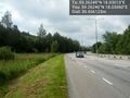
Speed raced here @59.2624,18.0306
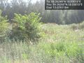
Stinging nettles @59.2626,18.0301
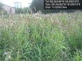
Thistles @59.2626,18.0301
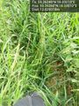
And thick grass @59.2626,18.0301
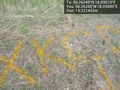
Orange @59.2626,18.0300
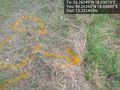
That way @59.2626,18.0300

Grin @59.2626,18.0300
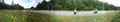
Panorama 1
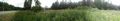
Panorama 2


