Difference between revisions of "2012-08-21 50 -2"
imported>NWoodruff |
imported>FippeBot m (Location) |
||
| (10 intermediate revisions by one other user not shown) | |||
| Line 7: | Line 7: | ||
}} | }} | ||
| − | + | =Location= | |
A wooded trail just outside of Sandford. | A wooded trail just outside of Sandford. | ||
[[Image:Map of hash.png | thumb | 500px | left | A map of the hash point]] | [[Image:Map of hash.png | thumb | 500px | left | A map of the hash point]] | ||
| + | |||
<br style='clear:left;' /> | <br style='clear:left;' /> | ||
| − | + | =Participants= | |
* [[User:DavidMiller|David Miller]] | * [[User:DavidMiller|David Miller]] | ||
* Ryan Miller | * Ryan Miller | ||
* Charlie Foulds | * Charlie Foulds | ||
| − | ==Plans== | + | [[Image:Geohash-21-08-2012-DSC 12620.jpg | thumb | 500px | left | We made it! woohoo!]] |
| + | <br style="clear:left;" /> | ||
| + | |||
| + | =Plans= | ||
| + | |||
| + | ==[[User:DavidMiller|David Miller's Plan]]== | ||
| + | |||
| + | I intend to get to the hash point around lunch time after finishing work. I will be bringing my son with me. | ||
| + | |||
| + | =Reports= | ||
| − | + | ==[[User:DavidMiller|David Miller's Report]]== | |
I arrived at the entrance to the wooded area at around 2pm. Gathered the kids and their lunches and headed off into the forest. Eventually found the hash point after around 15 minutes of walking and took some photos with the kids. There was a cool "den" just across from the hash point that someone has made from parts of trees that has been cut down. As the hash point was in in a dense part of the forest and no easy markings could be left, we grabbed a stick and etched "XKCD" into the soft mud path way to let people know we had been there. | I arrived at the entrance to the wooded area at around 2pm. Gathered the kids and their lunches and headed off into the forest. Eventually found the hash point after around 15 minutes of walking and took some photos with the kids. There was a cool "den" just across from the hash point that someone has made from parts of trees that has been cut down. As the hash point was in in a dense part of the forest and no easy markings could be left, we grabbed a stick and etched "XKCD" into the soft mud path way to let people know we had been there. | ||
| − | ==Gallery== | + | ===Gallery=== |
| − | <gallery | + | <gallery> |
| + | Image:Geohash-21-08-2012-DSC 12632.jpg | The long walk to the hash point. | ||
| + | Image:Geohash-21-08-2012-DSC 12621.jpg | The area where the hash was located was scattered with these lovely putple flowers. | ||
| + | Image:Geohash-21-08-2012-DSC 12612.jpg | The den that we found just across from the hash point. The kids had fun playing in it. | ||
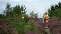
| + | Image:Geohash-21-08-2012-DSC 12603.jpg | My son Ryan on the way to the hash point. | ||
| + | Image:Geohash-21-08-2012-DSC 12610.jpg | Charlie being really patient with me as we locate the hash point. | ||
| + | Image:Geohash-21-08-2012-DSC 12609.jpg | This is where we sat to eat our lunch. | ||
| + | Image:Geohash-21-08-2012-DSC 12607.jpg | The actual hash point was approximately 1 meter to the left of this tree. We reached it, but it was not an ideal place to put a marker. | ||
| + | Image:Geohash-21-08-2012-DSC 12613.jpg | Our marker! | ||
| + | Image:Geohash-21-08-2012-DSC 12615.jpg | The boys wanted to make their own marker. | ||
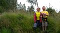
| + | Image:Geohash-21-08-2012-DSC 12620.jpg | Me and the boys. | ||
| + | Image:Geohash-21-08-2012-DSC 12618.jpg | posing for the camera! | ||
| + | Image:geohash-21-08-2012-DSC_12633.jpg | The boys searching for the rabbit we saw on our way back. | ||
| + | </gallery> | ||
| + | |||
| + | ===Achievements=== | ||
| + | |||
| + | {{Youngest geohasher | ||
| + | | latitude = 50 | ||
| + | | longitude = -2 | ||
| + | | date = 2012-08-21 | ||
| + | | name = DavidMiller | ||
| + | | name2 = Ryan | ||
| + | | years = 6 | ||
| + | | months = 9 | ||
| + | | image = Geohash-21-08-2012-DSC 12603.jpg | ||
| + | }} | ||
| + | {{Youngest geohasher | ||
| + | | latitude = 50 | ||
| + | | longitude = -2 | ||
| + | | date = 2012-08-21 | ||
| + | | name = DavidMiller | ||
| + | | name2 = Charlie | ||
| + | | years = 6 | ||
| + | | months = 9 | ||
| + | | image = Geohash-21-08-2012-DSC 12610.jpg | ||
| + | }} | ||
| + | |||
| + | |||
| + | {{land geohash | ||
| + | | latitude = 50 | ||
| + | | longitude = -2 | ||
| + | | date = 2012-08-21 | ||
| + | | name = DavidMiller | ||
| + | | image = Geohash-21-08-2012-DSC 12607.jpg | ||
| + | }} | ||
| + | |||
| + | |||
| + | {{Picnic_geohash | ||
| + | | latitude = 50 | ||
| + | | longitude = -2 | ||
| + | | date = 2012-08-21 | ||
| + | | name = DavidMiller | ||
| + | | food = Packed lunch | ||
| + | }} | ||
| + | |||
| + | {{drag-along | ||
| + | | latitude = 50 | ||
| + | | longitude = -2 | ||
| + | | date = 2012-08-21 | ||
| + | | partner = Ryan and Charlie | ||
| + | | name = DavidMiller | ||
| + | | image = Geohash-21-08-2012-DSC 12620.jpg | ||
| + | }} | ||
| + | |||
| − | |||
[[Category:Expeditions]] | [[Category:Expeditions]] | ||
[[Category:Expeditions with photos]] | [[Category:Expeditions with photos]] | ||
[[Category:Coordinates reached]] | [[Category:Coordinates reached]] | ||
| + | {{location|GB|ENG|DOR}} | ||
Latest revision as of 05:44, 13 August 2019
| Tue 21 Aug 2012 in Weymouth: 50.7228289, -2.1107242 geohashing.info google osm bing/os kml crox |
Contents
Location
A wooded trail just outside of Sandford.

Participants
- David Miller
- Ryan Miller
- Charlie Foulds

Plans
David Miller's Plan
I intend to get to the hash point around lunch time after finishing work. I will be bringing my son with me.
Reports
David Miller's Report
I arrived at the entrance to the wooded area at around 2pm. Gathered the kids and their lunches and headed off into the forest. Eventually found the hash point after around 15 minutes of walking and took some photos with the kids. There was a cool "den" just across from the hash point that someone has made from parts of trees that has been cut down. As the hash point was in in a dense part of the forest and no easy markings could be left, we grabbed a stick and etched "XKCD" into the soft mud path way to let people know we had been there.
Gallery
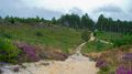
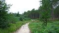
The long walk to the hash point.
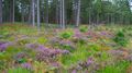
The area where the hash was located was scattered with these lovely putple flowers.
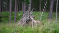
The den that we found just across from the hash point. The kids had fun playing in it.

My son Ryan on the way to the hash point.
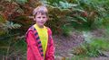
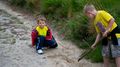
Charlie being really patient with me as we locate the hash point.
This is where we sat to eat our lunch.
The actual hash point was approximately 1 meter to the left of this tree. We reached it, but it was not an ideal place to put a marker.
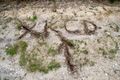
Our marker!
The boys wanted to make their own marker.

Me and the boys.
posing for the camera!
The boys searching for the rabbit we saw on our way back.


Achievements
DavidMiller earned the Youngest Geohash Achievement
|
DavidMiller earned the Youngest Geohash Achievement
|
DavidMiller earned the Land geohash achievement
|
DavidMiller earned the Picnic achievement
|
DavidMiller earned the Drag-along achievement
|