Difference between revisions of "2012-08-24 50 8"
imported>QuarterCacher ([live picture] Coordinates reached.) |
imported>FippeBot m (Location) |
||
| (3 intermediate revisions by one other user not shown) | |||
| Line 1: | Line 1: | ||
| − | |||
| − | |||
| − | |||
| − | |||
| − | |||
| − | |||
| − | |||
| − | |||
| − | |||
| − | |||
{{meetup graticule | {{meetup graticule | ||
| lat=50 | | lat=50 | ||
| Line 15: | Line 5: | ||
}} | }} | ||
| − | |||
__NOTOC__ | __NOTOC__ | ||
== Location == | == Location == | ||
| − | + | In the woods near Wiesbaden Frauenstein. | |
== Participants == | == Participants == | ||
| − | + | * [[User:QuarterCacher|QuarterCacher]] | |
| − | + | * [[User:LadyBB|LadyBB]] | |
| + | * [[User: Mampfred| Mampfred]] | ||
== Plans == | == Plans == | ||
| − | + | Go there late in the evening. | |
== Expedition == | == Expedition == | ||
| − | + | We met at 10pm and headed for another hash in the dark woods. Since [[User:EmmJay|EmmJay]] has started to be a good sleeper we simply left him at home (under the supervision of the grandparent but he didn't actually wake during the trip). | |
| + | |||
| + | The hash was just 50 meters off a track into the woods. The hash dance was a lot worse than usual, you can see that pretty good on the Garmin screenshot. Something was wrong with GPS that night anyway. If you look at the tracklog you can see that we took wuite different routes "down" and "up". That was in fact the same path but the GPS places us no less than 50 meters off the track while going down. | ||
| + | |||
| + | Since the hash was too easy really we tried to find a cache ([http://coord.info/GC2ARG9 GC2ARG9]) on the way back which turned out to be more difficult than expected due to darkness, rubbish GPS signals and the area being littered with dead tree branches. But between the three of us we eventually found the cache as well and returned home as happy hashers and cachers. | ||
== Tracklog == | == Tracklog == | ||
| − | + | See [http://www.everytrail.com/view_trip.php?trip_id=1737745 here]. | |
== Photos == | == Photos == | ||
| − | |||
| − | |||
| − | |||
<gallery perrow="5"> | <gallery perrow="5"> | ||
| − | + | Image:2012-08-24_50_8_coordinates_reached.jpg | Coordinates reached. | |
| − | Image:2012-08-24_50_8_22-46-42-821.jpg | | + | Image:2012-08-24_50_8_22-46-42-821.jpg | Stupid group shot. |
</gallery> | </gallery> | ||
== Achievements == | == Achievements == | ||
{{#vardefine:ribbonwidth|800px}} | {{#vardefine:ribbonwidth|800px}} | ||
| − | + | * Land | |
| − | |||
| − | |||
| − | |||
| − | |||
| − | |||
| − | |||
| − | |||
| − | |||
| − | |||
| − | |||
| − | |||
[[Category:Expeditions]] | [[Category:Expeditions]] | ||
| − | |||
[[Category:Expeditions with photos]] | [[Category:Expeditions with photos]] | ||
| − | |||
| − | |||
| − | |||
| − | |||
| − | |||
[[Category:Coordinates reached]] | [[Category:Coordinates reached]] | ||
| − | + | {{location|DE|HE|WI}} | |
| − | |||
| − | |||
| − | |||
| − | |||
| − | |||
| − | |||
| − | |||
| − | |||
| − | |||
| − | |||
| − | |||
| − | |||
| − | |||
| − | |||
| − | |||
| − | |||
| − | |||
Latest revision as of 05:46, 13 August 2019
| Fri 24 Aug 2012 in 50,8: 50.0742403, 8.1346662 geohashing.info google osm bing/os kml crox |
Location
In the woods near Wiesbaden Frauenstein.
Participants
Plans
Go there late in the evening.
Expedition
We met at 10pm and headed for another hash in the dark woods. Since EmmJay has started to be a good sleeper we simply left him at home (under the supervision of the grandparent but he didn't actually wake during the trip).
The hash was just 50 meters off a track into the woods. The hash dance was a lot worse than usual, you can see that pretty good on the Garmin screenshot. Something was wrong with GPS that night anyway. If you look at the tracklog you can see that we took wuite different routes "down" and "up". That was in fact the same path but the GPS places us no less than 50 meters off the track while going down.
Since the hash was too easy really we tried to find a cache (GC2ARG9) on the way back which turned out to be more difficult than expected due to darkness, rubbish GPS signals and the area being littered with dead tree branches. But between the three of us we eventually found the cache as well and returned home as happy hashers and cachers.
Tracklog
See here.
Photos

Coordinates reached.
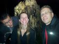
Stupid group shot.


Achievements
- Land