Difference between revisions of "2012-08-25 46 -123"
imported>Jiml m (Add result codes) |
imported>AeroIllini (→Plans) |
||
| Line 26: | Line 26: | ||
== Plans == | == Plans == | ||
| − | The plan is to drive down to the point from Seattle in the morning, and then make a | + | The plan is to drive down to the point from Seattle in the morning, and then make a [[2012-08-25 47 -122|meetup]] in Seattle at 4 pm. |
== Expedition == | == Expedition == | ||
Revision as of 00:25, 26 August 2012
| Sat 25 Aug 2012 in 46,-123: 46.5604246, -123.3612976 geohashing.info google osm bing/os kml crox |
Location
Just off Route 6, southwest of Centralia, WA.
Participants
Plans
The plan is to drive down to the point from Seattle in the morning, and then make a meetup in Seattle at 4 pm.
Expedition
The drive down to Centralia was uneventful. I turned onto Route 6 and immediately went into a cell service black hole. GPS coverage turned out to be spotty in the hills, as well. Luckily I had remembered the name of the road to turn on, which turned out to be a gravel road about half an hour down Route 6. Once on the gravel, I relied on the distance calculation provided by the Android app. Unfortunately, I was thwarted twice... once by No Trespassing sign, and once by some extremely marshy land when I tried to go around. I was not prepared to ford any rivers, so I stopped as close as I could to the point, which was about 600 ft distant. I'm calling this one a failure, unless someone else wants to declare that I have the benefit of the doubt and 600 ft is "close enough."
Photos
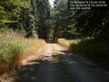
The road leading to the point. @46.5603,-123.3650

Me grinning, as close to the point as I could get. @.0000,.0000
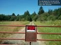
Thwarted! @46.5600,-123.3650
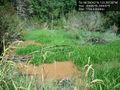
Thwarted again! This marshy land was between me and the point. @.0000,.0000
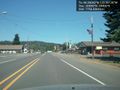
The sleepy town of Pe Ell, WA, along Route 6. Probably named for Superman's great-uncle. @.0000,.0000
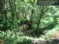
It was a rather nice walk in the woods. @.0000,.0000


Achievements