Difference between revisions of "2012-08-25 46 -123"
imported>AeroIllini (→Expedition) |
imported>AeroIllini (→Photos) |
||
| Line 38: | Line 38: | ||
Image:2012-08-25_46_-123_14-23-15-704.jpg | The gravel road leading to the point. | Image:2012-08-25_46_-123_14-23-15-704.jpg | The gravel road leading to the point. | ||
Image:2012-08-25_46_-123_14-25-35-079.jpg | Thwarted! This was my first path choice. | Image:2012-08-25_46_-123_14-25-35-079.jpg | Thwarted! This was my first path choice. | ||
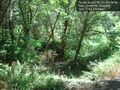
| − | Image:2012-08-25_46_-123_14-26-51-428.jpg | Thwarted again! This | + | Image:2012-08-25_46_-123_14-26-51-428.jpg | Thwarted again! This patch of swampiness was between me and the point on my second path choice. |
Image:2012-08-25_46_-123_14-24-11-197.jpg | Me grinning, as close to the point as I could get. My phone had lost GPS lock in this spot, which was slightly over 600 ft from the point. | Image:2012-08-25_46_-123_14-24-11-197.jpg | Me grinning, as close to the point as I could get. My phone had lost GPS lock in this spot, which was slightly over 600 ft from the point. | ||
Image:2012-08-25_46_-123_14-29-23-969.jpg | All in all, it was a rather nice walk in the woods. | Image:2012-08-25_46_-123_14-29-23-969.jpg | All in all, it was a rather nice walk in the woods. | ||
Revision as of 00:45, 26 August 2012
| Sat 25 Aug 2012 in 46,-123: 46.5604246, -123.3612976 geohashing.info google osm bing/os kml crox |
Location
Just off Route 6, southwest of Centralia, WA.
Participants
Plans
The plan is to drive down to the point from Seattle in the morning, and then make a meetup in Seattle at 4 pm.
Expedition
The drive down to Centralia was uneventful. I turned onto Route 6 and immediately went into a cell service black hole. GPS coverage turned out to be spotty in the hills, as well. Luckily I had remembered the name of the road to turn on, which turned out to be a gravel road about half an hour down Route 6. Once on the gravel, I relied on the distance calculation provided by the Android app. Unfortunately, I was thwarted twice... once by No Trespassing sign, and once by some extremely marshy land when I tried to go around. I was not prepared to ford any rivers, or brave any alligator-filled swamps, so I stopped as close as I could to the point, which was about 600 ft distant. Failure.
Photos
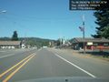
The sleepy town of Pe Ell, WA, along Route 6. Undoubtedly named for Superman's great-uncle.
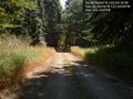
The gravel road leading to the point.
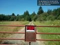
Thwarted! This was my first path choice.
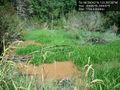
Thwarted again! This patch of swampiness was between me and the point on my second path choice.

Me grinning, as close to the point as I could get. My phone had lost GPS lock in this spot, which was slightly over 600 ft from the point.
All in all, it was a rather nice walk in the woods.


Achievements
AeroIllini earned the There might be alligators! consolation prize
|