Difference between revisions of "2012-08-26 54 -3"
imported>Alexandersmith (Created page with "{{subst:Expedition |lat = 54 |lon = -3 |date = 2012-08-26 }}") |
imported>FippeBot m (Location) |
||
| (3 intermediate revisions by one other user not shown) | |||
| Line 1: | Line 1: | ||
| − | |||
| − | |||
| − | |||
| − | |||
| − | |||
| − | |||
| − | |||
| − | |||
| − | |||
| − | |||
{{meetup graticule | {{meetup graticule | ||
| lat=54 | | lat=54 | ||
| Line 15: | Line 5: | ||
}} | }} | ||
| − | |||
| − | |||
== Location == | == Location == | ||
| − | + | Today's geohash was in an uncultivated field, near Little Urswick, England. | |
== Participants == | == Participants == | ||
| − | + | [[User:Alexandersmith|Alexandersmith]] | |
| − | |||
== Plans == | == Plans == | ||
| − | + | My plans for the day were similar to last week: To have a mountain bike ride in the early part of the day, and visit the meet-up point on the way back home to Barrow-in-Furness. | |
== Expedition == | == Expedition == | ||
| − | + | There is nothing out of the ordinary to report for this geohash. I was able to park next to the field, and walk to the geohash point via a gate which had obviously not been used for a long time. My total time in the field did not exceed 5 minutes. There was only grass growing in the field, so no damage done there. | |
== Tracklog == | == Tracklog == | ||
| − | + | There's no tracklog. I have a photo of my phone, with the Geohash app showing my location and the proximity to the geohash location. | |
== Photos == | == Photos == | ||
| − | < | + | <gallery perrow="2"> |
| − | Image: | + | Image:20120826 Geohash Achieved.JPG | Android Geohash app showing my location |
| − | + | Image:20120826 144921.jpg | Auto photo at the location | |
| − | |||
</gallery> | </gallery> | ||
== Achievements == | == Achievements == | ||
{{#vardefine:ribbonwidth|800px}} | {{#vardefine:ribbonwidth|800px}} | ||
| − | + | {{Land geohash | latitude = 54 | longitude = -3 | date = 2012-08-19 | name = Alexandersmith}} | |
| − | + | [[Category:Land geohash achievement]] | |
| − | |||
| − | |||
| − | [[Category: | ||
| − | |||
| − | |||
| − | |||
| − | |||
| − | |||
| − | |||
| − | |||
[[Category:Expeditions]] | [[Category:Expeditions]] | ||
| − | |||
[[Category:Expeditions with photos]] | [[Category:Expeditions with photos]] | ||
| − | |||
| − | |||
| − | |||
| − | |||
| − | |||
[[Category:Coordinates reached]] | [[Category:Coordinates reached]] | ||
| − | + | {{location|GB|ENG|CMA}} | |
| − | |||
| − | |||
| − | |||
| − | |||
| − | |||
| − | |||
| − | |||
| − | |||
| − | |||
| − | |||
| − | |||
| − | |||
| − | |||
| − | |||
| − | |||
| − | |||
| − | |||
Latest revision as of 05:49, 13 August 2019
| Sun 26 Aug 2012 in 54,-3: 54.1457475, -3.1297215 geohashing.info google osm bing/os kml crox |
Location
Today's geohash was in an uncultivated field, near Little Urswick, England.
Participants
Plans
My plans for the day were similar to last week: To have a mountain bike ride in the early part of the day, and visit the meet-up point on the way back home to Barrow-in-Furness.
Expedition
There is nothing out of the ordinary to report for this geohash. I was able to park next to the field, and walk to the geohash point via a gate which had obviously not been used for a long time. My total time in the field did not exceed 5 minutes. There was only grass growing in the field, so no damage done there.
Tracklog
There's no tracklog. I have a photo of my phone, with the Geohash app showing my location and the proximity to the geohash location.
Photos
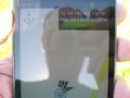
Android Geohash app showing my location
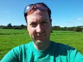
Auto photo at the location


Achievements
Alexandersmith earned the Land geohash achievement
|