Difference between revisions of "2012-09-02 50 -1"
imported>DavidMiller (→Gallery) |
imported>DavidMiller m (→Gallery) |
||
| Line 50: | Line 50: | ||
Image:Geohashing-02-09-2012-DSC 12895.jpg | Image:Geohashing-02-09-2012-DSC 12895.jpg | ||
Image:Geohashing-02-09-2012-DSC 12893.jpg | I cant take screenshots on my phone and [[user:KatieWheatley | Katie]] didn't have a signal to show where we were, so I had to settle for a photo! | Image:Geohashing-02-09-2012-DSC 12893.jpg | I cant take screenshots on my phone and [[user:KatieWheatley | Katie]] didn't have a signal to show where we were, so I had to settle for a photo! | ||
| − | + | Image:Geohashing-02-09-2012-DSC 12876.jpg | Some of the wild flowers / weeds. Not quite sure which! ( possibly "Sheep's bit" ) | |
| + | Image:Geohashing-02-09-2012-DSC 12878.jpg | A random purple flower ( possibly "Ragged Robin" ) | ||
| + | Image:Geohashing-02-09-2012-DSC 12879.jpg | The bee hard at work collecting nectar ( possibly "Oxford Ragwort" ) | ||
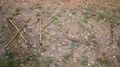
| + | Image:Geohashing-02-09-2012-DSC 12889.jpg | Those <s>dog prints</s> raptor tracks we found | ||
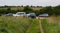
| + | Image:Geohashing-02-09-2012-DSC 12900.jpg | Some of the locals wondering what we are doing. | ||
| + | Image:Geohashing-02-09-2012-DSC 12902.jpg | Some more of the locals | ||
| + | Image:Geohashing-02-09-2012-DSC 12901.jpg | The fence that attacked Ryan when he touched it | ||
| + | Image:Geohashing-02-09-2012-DSC_12908.jpg | The location marker we left. It was made from the surrounding weeds! | ||
| + | Image:Geohashing-02-09-2012-DSC_12912.jpg | After finishing the marker, we left and made our way back to the car park. | ||
Revision as of 14:33, 3 September 2012
| Sun 2 Sep 2012 in Southampton: 50.9699702, -1.9189871 geohashing.info google osm bing/os kml crox |
Contents
Location
A nature reserver just outside of a little village called Martin.

Participants
- David Miller
- Ryan Miller
- KatieWheatley
- Chloé Miller
Plans
David Miller's Plans
Grab Kate and the kids and try and accomplish a multihash today. This is the first has we will hit. Afterwards we will travel over to 2012-09-02 50 -0
Reports
Katie Wheatley's Report
David Miller's Report
We left home around 2pm and headed out in the car to the hash point. It's only 33 miles but took an hour due to the types of roads we were travelling on. The journey was made much more enjoyable by some music we brought along.
We arrived at the hash point expecting it to be raining at this point, as that’s what the weatherman forecast in the morning. Luckily it was nice and dry. We made our way down some tracks and found the hash just slightly off to the right. As Kate is new to geohashing, she decided that she wanted to take the reins on this one and led the way. We took some photos and left a crude marker out of the weeds that were growing near by. We really must make a proper marker that we can leave at the hash point!
Along the route there were some flowers that I thought were lovely, they were probably weeds, but never the less they looked pretty, so I had to grab a quick photo of them. One had a bee (I think) gathering nectar; I got nice and close and snapped it. Further along the route after the hash point we saw some dog foot prints raptor tracks in the mud, we decided that it would be a good idea to be cautious! Just over from the tracks we saw some sheep, perhaps these were its food?
The sheep were enclosed in what seemed a harmless orange roped net fencing. Ryan went up for a closer inspection of the sheep and touched the rope. None of us had expected that the fencing would be electrified, Ryan promptly jumped backwards. After around 5 minutes, he seemed fine once again. A very brave chap!
Gallery
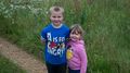
Ryan and Chloé raring to go geohashing
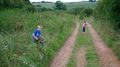
Katie navigating the way to the hash for the first time
Ryan investigating the area
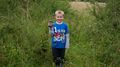
We found the hash point. Ryan wanted to show everyone!
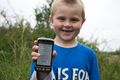

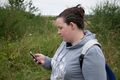
I cant take screenshots on my phone and Katie didn't have a signal to show where we were, so I had to settle for a photo!
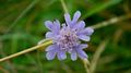
Some of the wild flowers / weeds. Not quite sure which! ( possibly "Sheep's bit" )
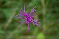
A random purple flower ( possibly "Ragged Robin" )
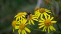
The bee hard at work collecting nectar ( possibly "Oxford Ragwort" )
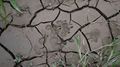
Those
dog printsraptor tracks we found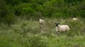
Some of the locals wondering what we are doing.
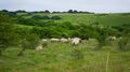
Some more of the locals
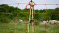
The fence that attacked Ryan when he touched it
The location marker we left. It was made from the surrounding weeds!
After finishing the marker, we left and made our way back to the car park.


