Difference between revisions of "2012-09-04 47 -122"
From Geohashing
imported>Thomcat ([live] On the spot - 7:06 am) |
imported>Thomcat (easy hash) |
||
| Line 1: | Line 1: | ||
| − | |||
| − | |||
| − | |||
| − | |||
| − | |||
| − | |||
| − | |||
| − | |||
| − | |||
| − | |||
{{meetup graticule | {{meetup graticule | ||
| lat=47 | | lat=47 | ||
| Line 15: | Line 5: | ||
}} | }} | ||
| − | |||
__NOTOC__ | __NOTOC__ | ||
== Location == | == Location == | ||
| − | + | Northbound 37th Ave near the county line in Lake Forest Park, North Seattle | |
== Participants == | == Participants == | ||
| − | + | * [[User:Thomcat|Thomcat]] | |
| − | |||
| − | |||
| − | |||
| − | |||
== Expedition == | == Expedition == | ||
| − | + | Geohash on the way to work; didn't even have to drive too far off my usual route. Had to drive past twice due to tree cover (the vehicular GPS dance), but got geohash droid to report "on the spot". Will come back with Sidewalk Chalk on the way home. | |
| − | |||
*On the spot - 7:06 am -- [[User:Thomcat|Thomcat]] [http://www.openstreetmap.org/?lat=47.77635760&lon=-122.29035001&zoom=16&layers=B000FTF @47.7764,-122.2904] 07:06, 4 September 2012 (PDT) | *On the spot - 7:06 am -- [[User:Thomcat|Thomcat]] [http://www.openstreetmap.org/?lat=47.77635760&lon=-122.29035001&zoom=16&layers=B000FTF @47.7764,-122.2904] 07:06, 4 September 2012 (PDT) | ||
| − | |||
| − | |||
== Photos == | == Photos == | ||
| − | |||
| − | |||
| − | |||
<gallery perrow="5"> | <gallery perrow="5"> | ||
| + | Image:2012-09-04 47 -122 stream.jpg | The stream alongside, just visible from a nearby driveway | ||
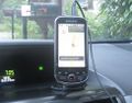
| + | Image:2012-09-04 47 -122 OnTheSpot.jpg | ||
| + | Image:2012-09-04 47 -122 geohasher.jpg | ||
</gallery> | </gallery> | ||
| Line 46: | Line 28: | ||
<!-- Add any achievement ribbons you earned below, or remove this section --> | <!-- Add any achievement ribbons you earned below, or remove this section --> | ||
| − | |||
| − | |||
| − | |||
| − | |||
| − | |||
| − | |||
| − | |||
| − | |||
| − | |||
| − | |||
| − | |||
[[Category:Expeditions]] | [[Category:Expeditions]] | ||
| − | |||
[[Category:Expeditions with photos]] | [[Category:Expeditions with photos]] | ||
| − | |||
| − | |||
| − | |||
| − | |||
| − | |||
[[Category:Coordinates reached]] | [[Category:Coordinates reached]] | ||
| − | |||
| − | |||
| − | |||
| − | |||
| − | |||
| − | |||
| − | |||
| − | |||
| − | |||
| − | |||
| − | |||
| − | |||
| − | |||
| − | |||
| − | |||
| − | |||
| − | |||
| − | |||
Revision as of 14:42, 4 September 2012
| Tue 4 Sep 2012 in 47,-122: 47.7763380, -122.2902606 geohashing.info google osm bing/os kml crox |
Location
Northbound 37th Ave near the county line in Lake Forest Park, North Seattle
Participants
Expedition
Geohash on the way to work; didn't even have to drive too far off my usual route. Had to drive past twice due to tree cover (the vehicular GPS dance), but got geohash droid to report "on the spot". Will come back with Sidewalk Chalk on the way home.
- On the spot - 7:06 am -- Thomcat @47.7764,-122.2904 07:06, 4 September 2012 (PDT)
Photos
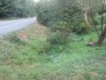
The stream alongside, just visible from a nearby driveway