Difference between revisions of "2012-09-11 51 0"
From Geohashing
imported>Lambert Simnel (→Photos) |
m |
||
| (12 intermediate revisions by 4 users not shown) | |||
| Line 1: | Line 1: | ||
| − | |||
<!-- If you did not specify these parameters in the template, please substitute appropriate values for IMAGE, LAT, LON, and DATE (YYYY-MM-DD format) | <!-- If you did not specify these parameters in the template, please substitute appropriate values for IMAGE, LAT, LON, and DATE (YYYY-MM-DD format) | ||
| Line 18: | Line 17: | ||
__NOTOC__ | __NOTOC__ | ||
== Location == | == Location == | ||
| − | Mersea Road, Colchester | + | Mersea Road, Colchester, UK |
== Participants == | == Participants == | ||
| − | Derek and Mari Sutherland | + | *[[User:Lambert Simnel|Derek and Mari Sutherland]] |
== Plans == | == Plans == | ||
<!-- what were the original plans --> | <!-- what were the original plans --> | ||
| + | Nope, no plans. Not a lot of forward thinking on this at all, actually. | ||
== Expedition == | == Expedition == | ||
| − | Err, we drove there. It wasn't far. We even managed to negotiate the tricky hedge that the geohash was located in. I forgot to re-set the GPS locator on my canera though, so we have a much blurred photo of my | + | Err, we drove there. It wasn't far. We even managed to negotiate the tricky hedge that the geohash was located in. I forgot to re-set the GPS locator on my canera though, so we have a much blurred photo of my Galaxy's Geohash Droid display instead... |
| − | |||
| − | |||
| − | |||
== Photos == | == Photos == | ||
| Line 37: | Line 34: | ||
--> | --> | ||
<gallery perrow="5"> | <gallery perrow="5"> | ||
| − | Image: | + | Image:Lambert3.jpg |Mari at the Colchester Geohash |
| − | Image: | + | Image:Lambert 1.jpg |Derek at the Colchester Geohash |
| − | Image: | + | Image:Lambert 2.jpg |My phone at the Colchester Geohash |
</gallery> | </gallery> | ||
| Line 45: | Line 42: | ||
{{#vardefine:ribbonwidth|800px}} | {{#vardefine:ribbonwidth|800px}} | ||
<!-- Add any achievement ribbons you earned below, or remove this section --> | <!-- Add any achievement ribbons you earned below, or remove this section --> | ||
| + | {{land geohash | latitude = 51 | longitude = 0 | date = 2012-09-11 | name = Lambert Simnel | image = Lambert_2.jpg }} | ||
| − | |||
| − | |||
| − | |||
| − | |||
| − | |||
| − | |||
| − | |||
| − | |||
| − | |||
| − | |||
| − | |||
[[Category:Expeditions]] | [[Category:Expeditions]] | ||
| − | |||
[[Category:Expeditions with photos]] | [[Category:Expeditions with photos]] | ||
| − | |||
| − | |||
| − | |||
| − | |||
| − | |||
[[Category:Coordinates reached]] | [[Category:Coordinates reached]] | ||
| − | + | {{location|GB|ENG|ESS}} | |
| − | |||
| − | |||
| − | |||
| − | |||
| − | |||
| − | |||
| − | |||
| − | |||
| − | |||
| − | |||
| − | |||
| − | |||
| − | |||
| − | |||
| − | |||
| − | |||
| − | |||
Latest revision as of 18:11, 18 March 2022
| Tue 11 Sep 2012 in 51,0: 51.8742128, 0.9079305 geohashing.info google osm bing/os kml crox |
Location
Mersea Road, Colchester, UK
Participants
Plans
Nope, no plans. Not a lot of forward thinking on this at all, actually.
Expedition
Err, we drove there. It wasn't far. We even managed to negotiate the tricky hedge that the geohash was located in. I forgot to re-set the GPS locator on my canera though, so we have a much blurred photo of my Galaxy's Geohash Droid display instead...
Photos
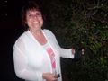
Mari at the Colchester Geohash
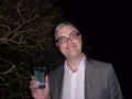
Derek at the Colchester Geohash
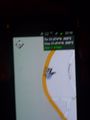
My phone at the Colchester Geohash


Achievements
Lambert Simnel earned the Land geohash achievement
|