Difference between revisions of "2012-09-22 48 9"
From Geohashing
imported>DarkMark ([live picture] Almost midnight [http://www.openstreetmap.org/?lat=48.77556324&lon=9.68647063&zoom=16&layers=B000FTF @48.7756,9.6865]) |
imported>Jiml m (Add some details) |
||
| Line 1: | Line 1: | ||
| − | |||
<!-- If you did not specify these parameters in the template, please substitute appropriate values for IMAGE, LAT, LON, and DATE (YYYY-MM-DD format) | <!-- If you did not specify these parameters in the template, please substitute appropriate values for IMAGE, LAT, LON, and DATE (YYYY-MM-DD format) | ||
| Line 15: | Line 14: | ||
}} | }} | ||
| − | + | ||
__NOTOC__ | __NOTOC__ | ||
== Location == | == Location == | ||
| − | + | ||
| + | Somewhere in Europe | ||
== Participants == | == Participants == | ||
| − | + | ||
| − | + | * [[User:DarkMark]] | |
| + | * Drag Along? | ||
== Plans == | == Plans == | ||
<!-- what were the original plans --> | <!-- what were the original plans --> | ||
| + | |||
| + | Unknown | ||
== Expedition == | == Expedition == | ||
<!-- how it all turned out. your narrative goes here. --> | <!-- how it all turned out. your narrative goes here. --> | ||
| + | |||
| + | Looks like they made it | ||
== Tracklog == | == Tracklog == | ||
| Line 46: | Line 51: | ||
<!-- Add any achievement ribbons you earned below, or remove this section --> | <!-- Add any achievement ribbons you earned below, or remove this section --> | ||
| + | * Land Geohash | ||
| + | * Midnight Geohash? | ||
<!-- =============== USEFUL CATEGORIES FOLLOW ================ | <!-- =============== USEFUL CATEGORIES FOLLOW ================ | ||
| Line 51: | Line 58: | ||
[[Category:New report]] | [[Category:New report]] | ||
| − | |||
| − | |||
| − | |||
| − | |||
| − | |||
[[Category:Expeditions]] | [[Category:Expeditions]] | ||
| − | + | ||
[[Category:Expeditions with photos]] | [[Category:Expeditions with photos]] | ||
| − | |||
| − | |||
| − | |||
| − | + | ||
[[Category:Coordinates reached]] | [[Category:Coordinates reached]] | ||
| − | |||
| − | |||
| − | |||
| − | |||
| − | |||
| − | |||
| − | |||
| − | |||
| − | |||
| − | |||
| − | |||
| − | |||
| − | |||
| − | |||
| − | |||
| − | |||
| − | |||
| − | |||
Revision as of 03:25, 23 September 2012
| Sat 22 Sep 2012 in 48,9: 48.7755541, 9.6864571 geohashing.info google osm bing/os kml crox |
Location
Somewhere in Europe
Participants
- User:DarkMark
- Drag Along?
Plans
Unknown
Expedition
Looks like they made it
Tracklog
Photos
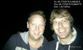
Almost midnight @48.7756,9.6865

Achievements
- Land Geohash
- Midnight Geohash?