Difference between revisions of "2012-09-22 48 9"
imported>DarkMark ([live picture] Almost midnight [http://www.openstreetmap.org/?lat=48.77556324&lon=9.68647063&zoom=16&layers=B000FTF @48.7756,9.6865]) |
imported>FippeBot m (Location) |
||
| (7 intermediate revisions by 3 users not shown) | |||
| Line 1: | Line 1: | ||
| − | |||
<!-- If you did not specify these parameters in the template, please substitute appropriate values for IMAGE, LAT, LON, and DATE (YYYY-MM-DD format) | <!-- If you did not specify these parameters in the template, please substitute appropriate values for IMAGE, LAT, LON, and DATE (YYYY-MM-DD format) | ||
| Line 15: | Line 14: | ||
}} | }} | ||
| − | + | ||
__NOTOC__ | __NOTOC__ | ||
== Location == | == Location == | ||
| − | + | ||
| + | Wäschenbeuren, in a corn field right next to a golf course. | ||
== Participants == | == Participants == | ||
| − | + | ||
| − | -- | + | * [[User:DarkMark]] |
| + | * [[User:M-o-D]] | ||
== Plans == | == Plans == | ||
| − | + | Saturday evening. We were bored but too tired to go out, so we thought about gecaching. We had never done that before and soon discovered that we suck at it. Out of 3 caches, we found not a single one. So let´s try geohashing. We were in quite some hurry in order to make it before midnight. | |
== Expedition == | == Expedition == | ||
| − | + | Once we got the technical equipment running it was quite easy to get near the spot. But there was no way to park at the main road, so we tried to approach from the other site. It turned out that there was a golf course, so we drove over a "road" on the golf course, and M-o-D was already in panic that someone might take his car while we where off to walk the last meters. Luckily the corn field was without corn, so a few minutes before midnight we arrived at the destination. Welcome to the new hasher, M-o-D, dragged along by DarkMark. | |
| − | + | Looks like we made it ! | |
| − | |||
== Photos == | == Photos == | ||
| − | + | ||
| − | |||
| − | |||
<gallery perrow="5"> | <gallery perrow="5"> | ||
| − | |||
Image:2012-09-22_48_9_23-56-28-383.jpg | Almost midnight [http://www.openstreetmap.org/?lat=48.77556324&lon=9.68647063&zoom=16&layers=B000FTF @48.7756,9.6865] | Image:2012-09-22_48_9_23-56-28-383.jpg | Almost midnight [http://www.openstreetmap.org/?lat=48.77556324&lon=9.68647063&zoom=16&layers=B000FTF @48.7756,9.6865] | ||
</gallery> | </gallery> | ||
| Line 46: | Line 43: | ||
<!-- Add any achievement ribbons you earned below, or remove this section --> | <!-- Add any achievement ribbons you earned below, or remove this section --> | ||
| + | * Land Geohash | ||
| + | * Midnight Geohash ! | ||
| − | |||
| − | |||
| − | |||
| − | |||
| − | |||
| − | |||
| − | |||
| − | |||
[[Category:Expeditions]] | [[Category:Expeditions]] | ||
| − | |||
[[Category:Expeditions with photos]] | [[Category:Expeditions with photos]] | ||
| − | |||
| − | |||
| − | |||
| − | |||
| − | |||
[[Category:Coordinates reached]] | [[Category:Coordinates reached]] | ||
| − | + | {{location|DE|BW|GP}} | |
| − | |||
| − | |||
| − | |||
| − | |||
| − | |||
| − | |||
| − | |||
| − | |||
| − | |||
| − | |||
| − | |||
| − | |||
| − | |||
| − | |||
| − | |||
| − | |||
| − | |||
Latest revision as of 06:14, 13 August 2019
| Sat 22 Sep 2012 in 48,9: 48.7755541, 9.6864571 geohashing.info google osm bing/os kml crox |
Location
Wäschenbeuren, in a corn field right next to a golf course.
Participants
Plans
Saturday evening. We were bored but too tired to go out, so we thought about gecaching. We had never done that before and soon discovered that we suck at it. Out of 3 caches, we found not a single one. So let´s try geohashing. We were in quite some hurry in order to make it before midnight.
Expedition
Once we got the technical equipment running it was quite easy to get near the spot. But there was no way to park at the main road, so we tried to approach from the other site. It turned out that there was a golf course, so we drove over a "road" on the golf course, and M-o-D was already in panic that someone might take his car while we where off to walk the last meters. Luckily the corn field was without corn, so a few minutes before midnight we arrived at the destination. Welcome to the new hasher, M-o-D, dragged along by DarkMark.
Looks like we made it !
Photos
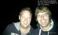
Almost midnight @48.7756,9.6865

Achievements
- Land Geohash
- Midnight Geohash !