Difference between revisions of "2012-09-23 39 -78"
From Geohashing
imported>Ldakota66 (→Photos) |
imported>Ldakota66 |
||
| Line 1: | Line 1: | ||
| − | |||
<!-- If you did not specify these parameters in the template, please substitute appropriate values for IMAGE, LAT, LON, and DATE (YYYY-MM-DD format) | <!-- If you did not specify these parameters in the template, please substitute appropriate values for IMAGE, LAT, LON, and DATE (YYYY-MM-DD format) | ||
| Line 9: | Line 8: | ||
And DON'T FORGET to add your expedition and the best photo you took to the gallery on the Main Page! We'd love to read your report, but that means we first have to discover it! :) | And DON'T FORGET to add your expedition and the best photo you took to the gallery on the Main Page! We'd love to read your report, but that means we first have to discover it! :) | ||
--> | --> | ||
| + | [[Category:Coordinates_reached]] | ||
{{meetup graticule | {{meetup graticule | ||
| lat=39 | | lat=39 | ||
Revision as of 02:40, 24 September 2012
| Sun 23 Sep 2012 in 39,-78: 39.0059613, -78.0873957 geohashing.info google osm bing/os kml crox |
Location
Off Milldale Farm Road in rural Warren County, VA.
Participants
Plans
I've been waiting to catch a geohash that was fairly local on a day I actually had time to go. Today was that day!
Expedition
Down the road we went and when the gps advised turn right we were faced with a security gate. We decided to brave it as we could easily pass the gate on foot. So with 0.2 mile to go we ditched the car by the road and set out on foot. We managed to reach the coordinates just in time to be chased off by some landowners who were less than happy to see us walking through their field. I did manage to snap a photo on the way back out to the road.
Tracklog
Photos
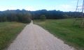
The one photo snapped on our supervised exit from the property.

Achievements