Difference between revisions of "2012-09-27 33 -117"
From Geohashing
imported>LucasBrown ([live picture] The tree with the sign [http://www.openstreetmap.org/?lat=33.88195134&lon=-117.95346596&zoom=16&layers=B000FTF @33.8820,-117.9535]) |
imported>FippeBot m (Location) |
||
| (3 intermediate revisions by 2 users not shown) | |||
| Line 1: | Line 1: | ||
| − | |||
| − | |||
| − | |||
| − | |||
| − | |||
| − | |||
| − | |||
| − | |||
| − | |||
| − | |||
{{meetup graticule | {{meetup graticule | ||
| lat=33 | | lat=33 | ||
| Line 15: | Line 5: | ||
}} | }} | ||
| − | |||
__NOTOC__ | __NOTOC__ | ||
== Location == | == Location == | ||
| − | + | A parking lot in Fullerton | |
== Participants == | == Participants == | ||
| − | + | [[User:LucasBrown|LucasBrown]] | |
| − | |||
| − | == | + | == Notes == |
| − | + | Part 2 of a doublehash (with [[2012-09-27 32 -116]]) | |
| − | |||
| − | |||
| − | |||
| − | |||
| − | |||
| − | |||
== Photos == | == Photos == | ||
| − | |||
| − | |||
| − | |||
<gallery perrow="5"> | <gallery perrow="5"> | ||
| − | |||
Image:2012-09-27_33_-117_18-34-32-567.jpg | Geohash Droid details page at the hashpoint [http://www.openstreetmap.org/?lat=33.88196680&lon=-117.95341694&zoom=16&layers=B000FTF @33.8820,-117.9534] | Image:2012-09-27_33_-117_18-34-32-567.jpg | Geohash Droid details page at the hashpoint [http://www.openstreetmap.org/?lat=33.88196680&lon=-117.95341694&zoom=16&layers=B000FTF @33.8820,-117.9534] | ||
| − | |||
Image:2012-09-27_33_-117_18-35-13-899.jpg | Geohash Droid map at the hashpoint [http://www.openstreetmap.org/?lat=33.88195576&lon=-117.95343645&zoom=16&layers=B000FTF @33.8820,-117.9534] | Image:2012-09-27_33_-117_18-35-13-899.jpg | Geohash Droid map at the hashpoint [http://www.openstreetmap.org/?lat=33.88195576&lon=-117.95343645&zoom=16&layers=B000FTF @33.8820,-117.9534] | ||
| − | |||
Image:2012-09-27_33_-117_18-43-43-256.jpg | Sign left at the hashpoint [http://www.openstreetmap.org/?lat=33.88200811&lon=-117.95332904&zoom=16&layers=B000FTF @33.8820,-117.9533] | Image:2012-09-27_33_-117_18-43-43-256.jpg | Sign left at the hashpoint [http://www.openstreetmap.org/?lat=33.88200811&lon=-117.95332904&zoom=16&layers=B000FTF @33.8820,-117.9533] | ||
| − | |||
Image:2012-09-27_33_-117_18-45-01-974.jpg | The tree with the sign [http://www.openstreetmap.org/?lat=33.88195134&lon=-117.95346596&zoom=16&layers=B000FTF @33.8820,-117.9535] | Image:2012-09-27_33_-117_18-45-01-974.jpg | The tree with the sign [http://www.openstreetmap.org/?lat=33.88195134&lon=-117.95346596&zoom=16&layers=B000FTF @33.8820,-117.9535] | ||
</gallery> | </gallery> | ||
| Line 50: | Line 25: | ||
== Achievements == | == Achievements == | ||
{{#vardefine:ribbonwidth|800px}} | {{#vardefine:ribbonwidth|800px}} | ||
| − | + | {{Multihash2 | count = 2 | date = 2012-09-27 | name = LucasBrown}} | |
| − | |||
| − | |||
| − | |||
| − | |||
| − | |||
| − | |||
| − | |||
| − | |||
| − | |||
| − | |||
| − | |||
[[Category:Expeditions]] | [[Category:Expeditions]] | ||
| − | |||
[[Category:Expeditions with photos]] | [[Category:Expeditions with photos]] | ||
| − | + | <!-- [[Category:Expedition without GPS]] Droid is running on a GPS enabled device ? --> | |
| − | [[Category:Expedition without GPS]] | ||
| − | --> | ||
| − | |||
| − | |||
[[Category:Coordinates reached]] | [[Category:Coordinates reached]] | ||
| − | + | {{location|US|CA|OR}} | |
| − | |||
| − | |||
| − | |||
| − | |||
| − | |||
| − | |||
| − | |||
| − | |||
| − | |||
| − | |||
| − | |||
| − | |||
| − | |||
| − | |||
| − | |||
| − | |||
| − | |||
Latest revision as of 06:18, 13 August 2019
| Thu 27 Sep 2012 in 33,-117: 33.8819631, -117.9534117 geohashing.info google osm bing/os kml crox |
Location
A parking lot in Fullerton
Participants
Notes
Part 2 of a doublehash (with 2012-09-27 32 -116)
Photos
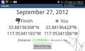
Geohash Droid details page at the hashpoint @33.8820,-117.9534
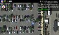
Geohash Droid map at the hashpoint @33.8820,-117.9534
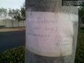
Sign left at the hashpoint @33.8820,-117.9533
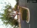
The tree with the sign @33.8820,-117.9535


Achievements
LucasBrown earned the Multihash Achievement
|